NYC CLOUDY DRIZZLE LIGHT RAIN BEFORE HEAT RETURNS
NYC CLOUDY DRIZZLE LIGHT RAIN BEFORE HEAT RETURNS
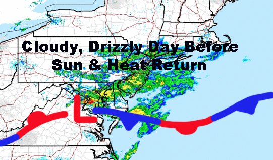
Good cloudy morning everyone. We had a little bit of a surprise develop late last night in the form of a wave that took shape over Pennsylvania, then moved along the old front which passed by late Saturday. This produced a shield of clouds and light rain (heavier rain down south), that moved into our area early in the morning. In the end, all this really does is represent our next very warm/hot airmass coming in.
SATELLITE


We start off Wednesday dry, but then expect humidity to slowly increase throughout the day. We remain sunny and very warm/hot, with highs again in the upper 80's to low 90's.

Thursday and Friday remain looking very warm and humid. The increased humidity, along with our warm temps, will help give us the chance of scattered afternoon storms each day. Highs will be in the upper 80's in most spots, but cooler at the beaches with an increased seabreeze.
For your weekend, we could get some slight relief humidity-wise, but we remain very warm/hot. We also took away the chance of storms on Sunday, as another ridge builds in and possibly keep the heat going in late week next week. Expect sunny conditions both Saturday and Sunday, with highs in the upper 80's to low 90's.

In the long range, we could be approaching "heatwave" territory Monday through Friday, but we'll have to keep an eye on the particulars and technicalities to see if we reach the definition of one.
Please note that with regards to any tropical storms or hurricanes, should a storm be threatening, please consult your local National Weather Service office or your local government officials about what action you should be taking to protect life and property.
Posted from my blog with SteemPress : https://www.nycweathernow.com/nyc-cloudy-drizzle-light-rain-before-heat-returns/