Mild Showery NYC Halloween Gusty Rumbles Overnight
Mild Showery NYC Halloween Gusty Rumbles Overnight
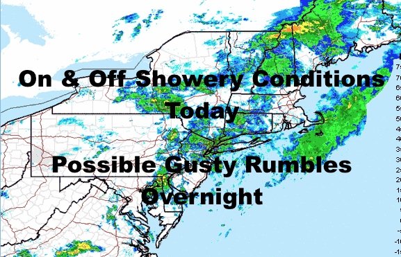
Good morning everyone. Our long-awaited system is here and showery conditions dot the Northeast. A break in the action remains possible, but at this point, you'll have to watch the radar for pop-up showers at any time between these patches of rain. Cool air is on schedule behind the system, and is the "milder" of the two scenarios I presented a couple of weeks ago; with low to mid 50's instead of 45-50 degree temps.
SATELLITE

Whatever window we do have, closes very fast as the evening/night wears on. A strong cold front will sweep by, bringing with it a line of heavy showers and some rumbles of thunder. Areas west of us could see some of those storms reach severe limits. The biggest concern is wind with this. We could even see a formidable gust front here as those storms peak before hitting us, with energy racing out ahead of the mature/dying line.

Rain and wind will end sharply and we could even wake up tomorrow to sunny skies. Even if we don't, sunny skies will be close and we should see a clear day with cobalt blue skies. Winds will pick up again if they already haven't, and we'll have a breezy and seasonably cool day in the low to mid 50's.

Low to mid 50's dominate through Monday, but how it feels on your skin will be different. Saturday remains the best day of the weekend with fairly light winds, then Sunday looks to be a breezy day. On Monday, winds calm down again, and it'll be the last cool day before 60's return.
Throughout this cool period, lows will range from the upper 30's to low 40's in the NYC area itself. However, lows could dip into the low to mid 30's for parts of Long Island, where typically colder spots could see some frost. N&W of the City, widespread frost or freeze is possible as lows could dip into the upper 20's to low 30's.

In the long range, we modify temps with low pressure drifting offshore and giving us a return-flow from the south. Look for 60's for most of next week, then another cool shot of air is possible behind our next system at the end of next week/weekend.
Please note that with regards to any tropical storms or hurricanes, should a storm be threatening, please consult your local National Weather Service office or your local government officials about what action you should be taking to protect life and property.
Posted from my blog with SteemPress : https://www.nycweathernow.com/mild-showery-nyc-halloween-gusty-rumbles-overnight/