Hurricane Dorian Slams Carolinas Quiet Block Ahead After Saturday Exit
Hurricane Dorian Slams Carolinas Quiet Block Ahead After Saturday Exit
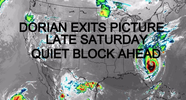
Good afternoon everyone. Hurricane Dorian continues to hold it's own, maintaining strength between a strong Category 2/"Weak" Category 3 status. Strong bands coming in off the ocean are spawning tornadoes, especially areas of northern South Carolina, and into North Carolina, where Wilmington is having a rough time.
Dorian will continue to move slowly until it makes a full turn to go northeast, then begin to accelerate. Until then, expect damaging storm surge, strong winds, and embedded severe storms with tornadoes to continue in the Carolinas, then into parts of the Mid-Atlantic. We'll see some fringe effects here, then maybe a stronger influence around Cape Cod on Saturday, before going off the map late at night.
SATELLITE

For us, we'll remain cloudy for the rest of the day as Dorian's cloud shield has spread will north and well inland. Cloud cover is thick enough, combined with light NE winds, to hinder temps from rising anymore than what we see right now. Expect highs a steady and uniform low 70's throughout the area.

Tomorrow, Dorian's approach and southeast passage will be felt a little more, but nothing major for our area. High surf, some enhanced tide, a breezy/cloudy day, and the slight chance of showers (especially in the afternoon) will be with us. Highs near 70 tomorrow again.
Overnight tomorrow, we'll have a better shot at some gusty showers, especially as Dorian interacts with the mechanism that's helping to kick it away from us. We could see gusty, Dorian-enhanced showers developing to our west, then drift over our area as Dorian pulls away. Expect winds in the 15-20mph range, with possibly some higher gusts, especially during any showers AND the further east you go; such as the Forks of Long Island.

Once Hurricane Dorian is gone, we have beautiful air ushering in. Expect sunny skies and mid to upper 70's both Saturday and Sunday, with low humidity and a seasonal feel overall.
We'll cool off a bit on Monday, then maybe even drop a few more degrees on Tuesday before the air ahead of the next system helps get us back to near-seasonal temps.

Please note that with regards to any tropical storms or hurricanes, should a storm be threatening, please consult your local National Weather Service office or your local government officials about what action you should be taking to protect life and property.
Posted from my blog with SteemPress : https://www.nycweathernow.com/hurricane-dorian-slams-carolinas-quiet-block-ahead-after-saturday-exit/