NYC Similar Thursday System Arriving Tuesday
NYC Similar Thursday System Arriving Tuesday
Good morning everyone. We have another cold one today before things moderate a bit for a couple of days, then we rinse and repeat in terms of another system heading in with very cold air behind it. As Meteorologist Joe Cioffi says, "Sometimes the pattern rhymes", and this one will rhyme very much with this past Thursday.
SATELLITE

We don't dip down too much tonight, and that signals the "milder" air moving in. We'll also have clouds and sun tomorrow as the air begins to become more moist, but it'll be a nice precipitation-free day. Highs tomorrow in the low to mid 50's.

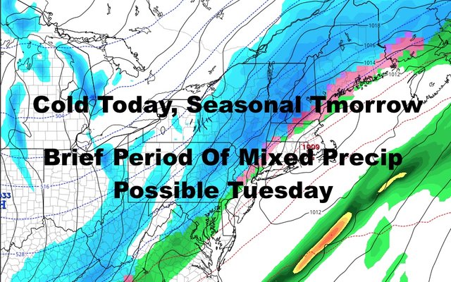
Monday remains dry as well, but we'll lower and thicken the clouds as the day goes on. Those clouds represent our next system, and it'll be very similar to this past Thursday's rainmaker. Highs Monday a seasonal mid to upper 50's.
Overnight Monday and into Tuesday, a cold rain heads in. It doesn't look like we'll break the 40's, and that'll set us up for a possible brief mix or a few wet snowflakes as everything comes to a close. Just like Thursday, it all depends on if we still have enough moisture in the area as that cold air heads in. We'll have enough cold air aloft, that even in the low 40's, you could see a few wet globs of slushy mush mixed with rain hitting your windshield. Let's see what happens, but regardless, the cold air will be the big story once again, not this fleeting moment of mixed precipitation.

Cold air locks in Tuesday night, and areas N&W of NYC could see some teens if conditions allow. NYC itself will see mid 20's as lows, and Long Island will see low 20's throughout. Some upper teens to near 20 lows are possible in more remote areas of Long Island, such as the Pine Barrens and Hamptons.
On Wednesday we don't recover much and it'll be a windy one like yesterday. We'll probably have the coldest day of the season so far, with mid 30's expected for highs. On Thursday, we begin to modify a bit and break out of the 30's, but we remain unseasonably cold.
These cold blasts seem to stick around for only a couple of days, and this one looks no different. Expect a return to average/near-average temps Friday and into next weekend.

Please note that with regards to any tropical storms or hurricanes, should a storm be threatening, please consult your local National Weather Service office or your local government officials about what action you should be taking to protect life and property.
Posted from my blog with SteemPress : https://www.nycweathernow.com/nyc-similar-thursday-system-arriving-tuesday/