NYC Latest Winter Storm Update
NYC Latest Winter Storm Update
Good morning everyone. For those waking up and asking themselves, "why is there nothing going on?", it's because our system is still a couple of hours away as expected. Temps are cold enough to initially support a brief period of snow/mix in the NYC & Long Island area, but it may take longer to get steady precip into the region. We continue to watch part 2 of our winter storm, which will be the one to bring some true flakes into the area; and will also be the one to pound interior parts of the Northeast.
SATELLITE

We're starting off cloudy and cold as we await the precipitation field to make it our way. Things will start off scattered and light, then the atmosphere will quickly "warm" up enough to cut the legs off of any frozen precip. That being the case, we will dial back to the initial forecast from a few days ago, and go for a trace- 1/2" of snow and sleet possible before we changeover to a cold rain. Yesterday, we were saying a trace-2", but the initial onset of precip is not organized enough.
So look for a brief period of snow, then a rain/sleet mix, then a cold rain for the rest of the day and into the night time. Little to no accumulation is expected at the immediate, south-facing shores, and that general trace - 1/2" elsewhere in the NYC/LI Area. Highs today in the upper 30's to low 40's.

Tomorrow remains tricky as we watch that energy transfer in the late morning/early afternoon while temperatures don't recover from mid to upper 30's overnight tonight. Expect a morning cold rain, then mixed precip mid-afternoon with temps sinking into the low 30's. Any mix should change over to light snow (moderate at times) by evening.
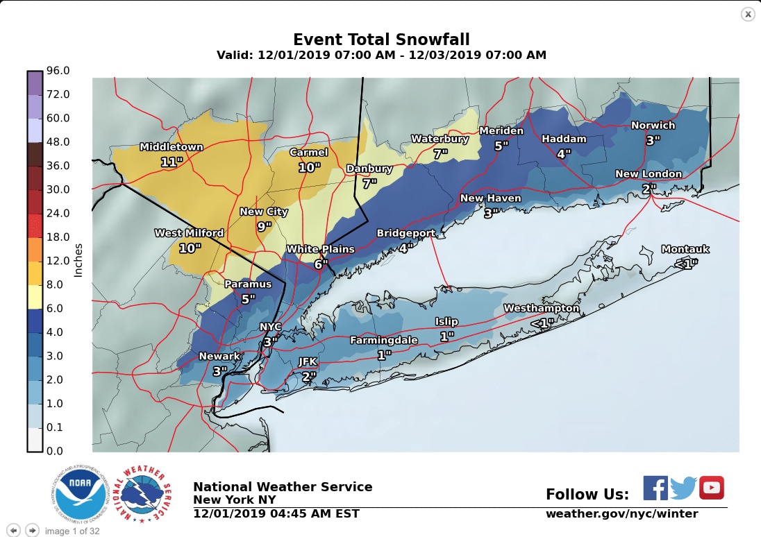
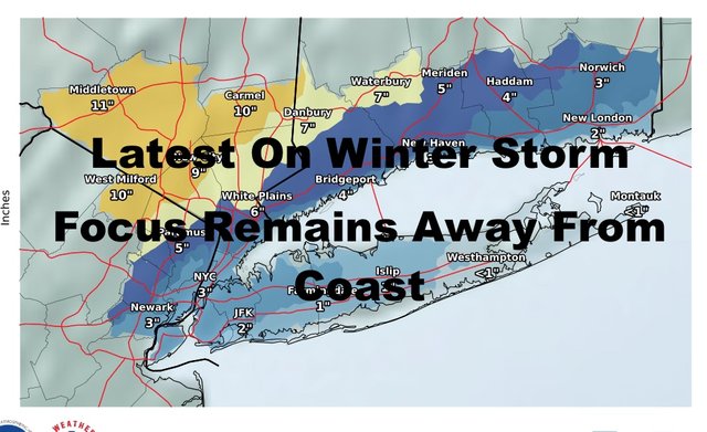
Let's take today's frozen precip out of the equation and talk about what you'll visually see tomorrow/tomorrow night. Expect a trace - 2" of snow in central Brooklyn, central and northern Queens, central and northern Nassau, and parts of central and northern Suffolk. The south shore of Long Island and East end remain on the low side, with a trace -1" possible.
Remember, when the snow first starts falling, it's going to be falling on wet ground. Colder surfaces such as cars and tree branches will turn white first. Treated roads may not see anything at all, maybe a little slush with a white coating.
Areas of Manhattan may see 1-3" of snow on the back end, and a possible upside if that little hook of heavy snow gets close. Areas well N&W of NYC will see a general 6-12" of snow, with a few pockets of 10-18"+ mixed in where the heaviest snow sets up. Right now we can't predict who will see that, but higher elevations have the best chance with the lift-factor taken into consideration.
In between that 1-3" and the 6-12", will be areas that may see a 4-8" snowfall. This is also another area that'll be very difficult to predict, because we're talking about a 10-15 mile margin of error. The best thing to do is for those away from NYC, is to prepare for plowable snow, and be aware that Monday night and Tuesday morning's commute is going to be an issue.

Tuesday morning's commute will be an issue for the NYC area as well, with locally icy roads as anything that falls will freeze on untreated roads. Eventually, the sun will come out and it'll look like nothing happened by late afternoon as highs reach near 40.
Anything visual that does happen to survive, will be taken care of Wednesday with sun and clouds and highs in the low 40's.
Please note that with regards to any tropical storms or hurricanes, should a storm be threatening, please consult your local National Weather Service office or your local government officials about what action you should be taking to protect life and property.
Posted from my blog with SteemPress : https://www.nycweathernow.com/nyc-latest-winter-storm-update/
Congratulations @joewxman! You have completed the following achievement on the Steem blockchain and have been rewarded with new badge(s) :
You can view your badges on your Steem Board and compare to others on the Steem Ranking
If you no longer want to receive notifications, reply to this comment with the word
STOPTo support your work, I also upvoted your post!
Vote for @Steemitboard as a witness to get one more award and increased upvotes!