NYC Heavy Rain Expected Tomorrow Night Windy Cool Thursday Ahead
NYC Heavy Rain Expected Tomorrow Night Windy Cool Thursday Ahead
Good morning everyone. We have a nice, quiet day today before things get going tomorrow afternoon with our next system. I don't think we'll see any surprises tomorrow as everything is unfolding as expected and on schedule. Meanwhile, our long range brief warmth possibilities are not going to pan out completely, and we have a shot at our first taste of cold air towards the end of the month.
SATELLITE


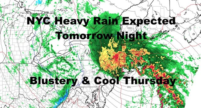
Things get going just before the energy goes to our east, just enough to bring a period of heavy rain into the area. However, the storm doesn't really begin to wrap up until it moves into New England. What this means for us is tat we'll start of with some scattered showers tomorrow afternoon, then rain will become steadier and heavier as we go on. Our heaviest rain will probably be overnight tomorrow, with maybe even a few rumbles of thunder as that low pressure begins to strengthen. Highs tomorrow will be in the mid to upper 60's. As far as flooding concerns, look for localized flooding and ponding on the roads in poor drainage areas during periods of heavy rain.
In cases like this, our heaviest rain will probably be just before that majority of precipitation moves away, then we should have scattered showers or some light rain into early Thursday morning. This is when we will start to see our strongest winds develop. Low pressure will wrap up nicely in New England, and that'll give us a very windy day on Thursday. For those curious as to what type of storm this "would've been" in the dead of winter, it wouldn't have changed much for us, but could've been a blockbuster for interior NY and New England. We would've seen heavy rain with maybe a period of sleet or snow at the very end.
Look for cool and blustery conditions on Thursday with a strong NNE wind to start, then going NNW. Highs in the 55-60 range.

We could start off Friday with a breeze in the morning, then subsiding as the day goes on and that low pulls well away from New England. Sunny skies will dominate as will seasonably cool air. Expect highs in the low 60's.
Saturday will be a repeat with low 60's, minus the breezy morning; then we slowly warm up Sunday with our next system off to our west. We could squeeze out one more sunny day Sunday, or some increasing clouds late. Highs Sunday in the upper 60's to low 70's.
Monday warmth/mildness will depend on the position of our high pressure as it moves off of the coast, and cloud cover. For now, we'll call for sun and clouds and highs again in the upper 60's to low 70's. 65-70 if the cloud cover is thicker, 70-75 if we get more sun.
The prospect of an extra warm day on Tuesday is fading as that front may be knocking on our door with some rain. Stay tuned on that as we have a long way to go.

In the long range though, that chance of 70's may be the last unless we get an odd day in November. Our pattern may be in for a big change with the Jet Stream dipping into the Northeast as a ridge develops on the West Coast. This is usually how it goes at some point in the fall, and this could give us our first taste of very cool/cold air into the region during the daytime. We might also get our first official frost here in the NYC/Long Island area towards the end of the month.
Please note that with regards to any tropical storms or hurricanes, should a storm be threatening, please consult your local National Weather Service office or your local government officials about what action you should be taking to protect life and property.
Posted from my blog with SteemPress : https://www.nycweathernow.com/nyc-heavy-rain-expected-tomorrow-night-windy-cool-thursday-ahead/