Discovering your own Archaeological Site : Part 3 - Final

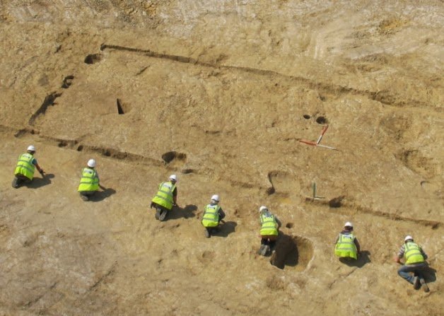
Today aerial photography is often used to trace archaeological deposits. By studying the contour lines of elevations and depressions which are seen more clearly from the air than they are from the ground (as a result of the shadow effect), and by taking into consideration the light which is reflected from the different types of soil, one is often able to distinguish the layout of an old settlement, and it can be investigated systematically.
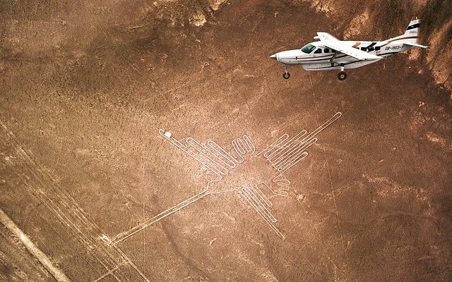
Nazca Lines : The Humming Bird
Many archaeological features which are almost invisible at ground level are detected clearly from the air. These include low stone terraces or village walls, ploughed fields and old pathways.Photography taken from low flying an aeroplane or balloons may also show shadows sites, crop mark sites and soil marks. Shadows sites show up early or late in the day when shadows of walls or earthworks are clearly defined. Crop mark sites are visible because disturbances beneath crops cause variations in their height, vigor and type. One would for example find lusher and denser vegetation in rich soil such as that covering a buried ditch or pit.
Differently colored or textured soil (soil marks) might indicate ploughed out burial mounds. Moisture differences could also possibly point to disturbances. Damp sites are areas where soil remains damp for longer following precipitation and may occur over walls or embankments.
Satellite photography also has the potential to make a valuable contribution to archaeology. LANDSAT (Earth Resources Technology) satellites that orbit the earth transmit a record of reflected light and infra-red radiation from the earth's surface in the shape of photographic images .These images can indicate the location of archaeological sites.

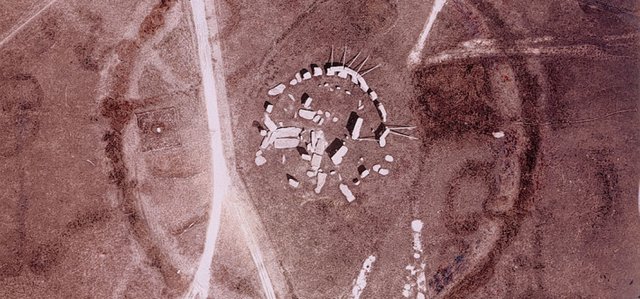
Castles in the desert – satellites reveal lost cities of Libya
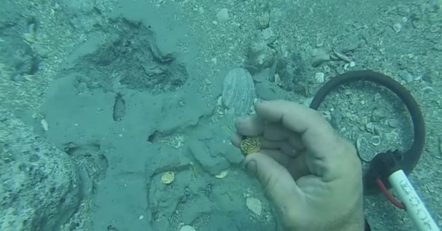
Underwater Reconnaissance
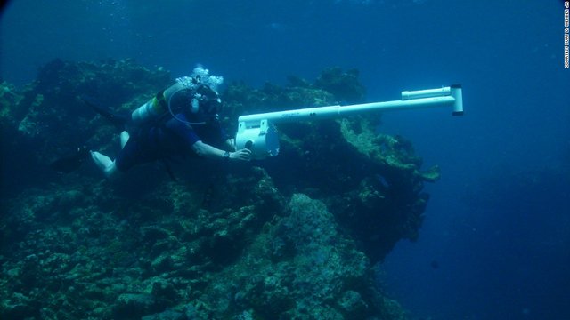
This type of reconnaissance is used mainly to detect shipwrecks. Surveys are usually planned in areas where shipwrecks have been known to occur and aim to record all the available archaeological material. Besides diving, underwater archaeologists use sophisticated technological aids that include the Proton Magnetometer, which detects iron and steel objects. The sound waves sent out by a Side scan Sonar bounce off the seabed to give a graphic reconstruction of it and to indicate the presence of large objects such as shipwrecks.
Hi-Tech Alternatives
The process of locating archaeological sites nowadays has seen an explosion of alternative and exciting new technology. The GPS (Global Positioning System) is an instrument that locks into signals transmitted by satellites and that subsequently provides mapping co-ordinates that can be imported into GIS systems for geo-referencing analysis of sites and features. (Hall 1996:92).
What are GIS and Remote Sensing Systems?
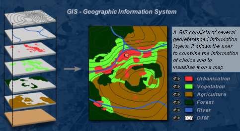
Geographic Information Systems (GIS) are computer software that allows layering of various types of data to produce complex maps, useful for predicting site location and for representing the analysis of collected data within sites and across regions. Remote sensing is the small or large scale acquisition of information of an object or phenomenon, by the use of either recording or real time sensing device(s) that is not in physical or intimate contact with the object (such as by way aircraft, spacecraft or satellite). Here, ground based geophysical methods such as Ground Penetrating Radar and Magetometry are often used for archaeological imaging.

Several methods of remote sensing beneath the surface or in the water are currently used. These would include seismic and acoustic methods,the use of radio waves and electric impulses, magnetic and metal detectors.
So now my dear readers we have followed all the possible ways of you Discovering your own Archaeological Site and........You have discovered the Next Archaeological find of the Century!
Congratulations!!!!
What must we do Next?
Context
The archaeological context is a combination of the recording of the immediate surrounding matrix (eg: soil, ash, gravel), the provenience (horizontal and vertical position within the matrix) and the association of the finds (ie: the occurrence together with other archaeological material).
The following three factors affect the context:
1. The manufacturing method and original use of the object, house or artefact (eg: deliberate orientation of the structure, placement in a grave, etcetera)
2. The way in which the find was deposited (deliberately buried as grave goods or a hoard, accidental displacement such as the breaking of a string of beads, catastrophic events such as volcanic eruptions, floods)
3. The subsequent history of the find in the deposit (deliberate or accidental disturbance, site formation factors, etectera)
Primary and Secondary Context
Primary context refers to the situation where the original artefact or structure was undisturbed by natural or human factors until excavation. Secondary context refers to the situation where disturbance or displacement by later, ecological action or human activities occurred.
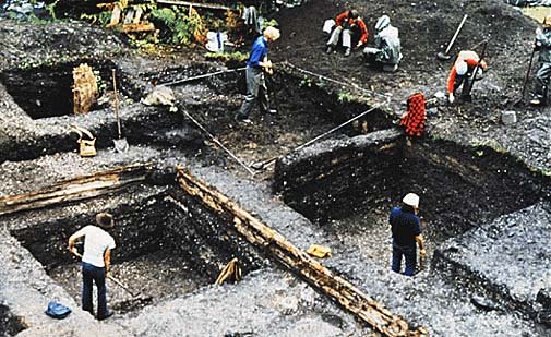
Matrix
This refers to material in which the find is situated (sediments such as sand, ashy soil, mud, water, etcetera). The matrix may be of natural origin or human-made.
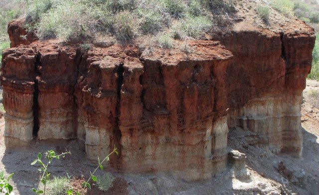
At Olduvai Gorge, the tool scatters and bone left by hominins next to a shallow lake and ultimately covered by sand and, some time later, shallow water, demonstrates the formation of matrices of natural origin.
Hunter gatherers living in a rock shelter carrying in bedding material, make fires which form ashy patches, dump in the inedible remains of food around hearth areas and leave behind the debris of tool manufacture. The resultant deposit is human made, for example the shell middens found in the shelters in the Robberg Peninsula in the Southern Africa, Cape.
Provenance
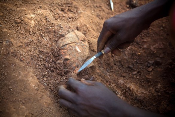
Provenance (provenience) is the horizontal and vertical position in which artefacts are found and recorded by the archaeologist when excavating the deposit or matrix.
A deposit is formed by the laying down of occupation layers one above the other and is stratified. Artefacts found in the lower levels were deposited before the artefacts found in the layers above them. The artefacts, features and structures found in the layers of a site are therefore in a relative chronological sequence, with the earliest at the bottom and the latest on the top. This is known as the principle of superposition.
Association with other Finds
The possible associations between different finds are demonstrated through the co-occurrence of an artefact with other archaeological remains, usually in the same layer. This is known as the principle of association.
An example of secondary context is where Stone Age tools were moved by natural action of water to a location far from the original place of deposition. The deliberate robbing of some of the grave furnishings from the tombs of the Egyptian pharaohs before they were rediscovered and scientifically excavated is another example of finds discovered in a secondary context.
References: Renfrew & Bahn (2008:52)
Renfrew & Bahn (1996:90-96)
Hall (1996:88-89)
Please Follow me for more on Archaeology and History.
Please check out my other posts:
Discovering your own Archaeological Site : Part 2
Discovering your own Archaeological Site : Part 1
Archaeological Sealed Sites and River Deposits : Is it an Archaeological Site or Not? - Part 3
Caves, Rock Shelters and Larger Open-Air Sites : Is it an Archaeological Site or Not? - Part 2
Is it an Archaeological Site or Not? - Part 1
Understanding the Archaeological Record : The Aims and Subject Matter of Archaeology - Part 2
The Aims and Subject Matter of Archaeology - Part 1
Archaeology and the Natural Sciences
Introduction to Ethnographic Analogy and Ethnoarchaeology
The Nature and Scope of Archaeology
The Three - Age System : The Stone Age, The Bronze Age and The Iron Age
The Roots of Modern Archaeology
Significant 18th and 19th Centuries Discoveries in Archaeology
Archaeology as a Profession- Part 2
Archaeology as a Profession- Part 1
To Become or Not Become an Archaeologist? - Introduction to Archaeology Part 2
Please Upvote and Resteem.
Thank You!
This is good and detailed! Thanks for sharing!
Congratulations @zest! You have completed some achievement on Steemit and have been rewarded with new badge(s) :
Click on any badge to view your own Board of Honor on SteemitBoard.
For more information about SteemitBoard, click here
If you no longer want to receive notifications, reply to this comment with the word
STOPThis post has received a 1.56 % upvote from @drotto thanks to: @banjo.