Incanto di Sabang La bellezza dell'isola più occidentale dell'Indonesia
A Weh Island c'è un lago d'acqua dolce chiamato Lake Aneuk Laot.
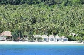
Island Weh è un'isola vulcanica, un'isola atollica (isola corallina) che ha il processo di verificarsi di sollevamento dalla superficie del mare. Il processo di occorrenza in tre fasi, evidente dall'esistenza di tre terrazze situate a diverse altezze.
Generalmente Weh Island the compone di due tipi in roccia, ovvero il porto di tufo e il nucleo di roccia. Tuf marina si trova quasi lungo la costa fino all'altezza at 40 a 50 metri. I ciuffi più larghi si trovano intorno alla città di Sabang, su una spiaggia stretta. Stretta roccia è roccia vulcanica andesitica.
Sulla base della regione, sembra che la regione occidentale on Weh Island abbia la topografia più severa. Partendo da Sarong Kris come la vetta più alta in Oriente, ci sono tre file in dorsi che si stanno dirigendo verso nord-ovest, quindi le valli che si trovano tra le schiene sono strette.
Topografia ad est c'è una montagna quella direzione da nord a sud che separa l'isola di Weh orientale con altre parti. Mount Leumo Mate è la vetta più alta. In questa sezione c'è uno strato più grande at the marina di tufo. Tra l'Occidente e l'Oriente ci sono flussi di due fiumi, vale a dire Sungai Laot e Sungai Sungai Raya. Questa zona è una slenk in un fleksun (un punto di riferimento imperfetto).
Le condizioni geologiche in the questa regione sono costituite dal 70% in roccia vulcanica (andesite), 27% in roccia sedimentaria (linea stone e sand stone) 3% in alluvionale deposits (recente deposits).
Weh Island ha vissuto due stagioni, la stagione delle piogge e la stagione secca. La stagione delle piogge in genere cade da settembre a febbraio. Stagione secca da marzo ad agosto Secondo le misurazioni della stazione meteorologica di Sabang, una media delle precipitazioni at 1,745 - 2,232 mm / anno, con il numero più basso in marzo a 18 mm e la cifra più alta nel mese in settembre at 276 mm. A settembre e ottobre c'è stata una transizione dalla stagione secca alla stagione delle piogge.
The city of Sabang before World War II was the most important port city compared to Temasek (now Singapore).
Sabang has been widely known as a natural harbor named Kolen Station by the Dutch colonial government since 1881. In 1887, Firma Delange assisted Sabang Haven to gain the authority to add, build port facilities and facilities. The free harbor era in Sabang was started in 1895, known as vrij haven and managed by the Maatschaappij Zeehaven en Kolen Station, then known as Sabang Maatschaappij. World War II influenced the condition of Sabang where in 1942 Sabang occupied by Japanese troops, then bombed Allied aircraft and suffered physical damage until it was forced to close.
In the early days of Indonesia's independence, Sabang became the naval defense center of the Republic of Indonesia (RIS) with the full authority of the government through the Decree of the Minister of Defense RIS Number 9 / MP / 50. All Sabang Maatschaappij port assets are purchased by the Government of Indonesia. Then in 1965 formed the government of Sabang Municipality based on Law No. 10/1965 and initiated the initial idea to reopen as Free Port and Free Trade Area.
The idea was then realized and reinforced by the issuance of Law No. 3/1970 on Sabang Free Trade and Law No. 4/1970 on the establishment of Sabang as a Free Trade Area and Free Port. And on the grounds of the opening of Batam Island as Free Trade Zone and Free Port of Batam, Sabang was forced to be shut down based on Law No. 10/1985. Then in 1993 formed Regional Economic Cooperation Indonesia-Malaysia-Thailand Growth Triangle (IMT-GT) which makes Sabang very strategic in economic development in South Asia region.
In 1997 at Pantai Gapang, Sabang, Jamboree Sciences and Technology (Iptek) initiated by BPPT with the focus of the study wanted to re-develop Sabang. Followed later in 1998, Sabang City and Pulo Aceh Sub-district were designated as Integrated Economic Development Zone (KAPET) together with other KAPET, inaugurated by President BJ Habibie with Keppes. 171 of 1998 on 28 September 1998.
A new era for Sabang, when in 2000 occurred Sabang Declaration as Free Trade Zone and Free Port by President KH. Abdurrahman Wahid in Sabang with the issuance of Inpres no. 2 of 2000 on January 22, 2000. And then the issuance of Government Regulation in lieu of Law no. 2 year 2000 dated September 1, 2000 is further legalized into Law Number 37 Year 2000 on Free Trade Area and Sabang Free Port.
The activities of Free Port and Sabang Free Trade in 2002 began to pulsate with the entry of goods from abroad to Sabang area. But in 2004 this activity stopped because Aceh was designated as a Military Emergency Area.
Sabang also experienced the Earthquake and Tsunami on December 26, 2004, but because of the very deep trenches of Sabang Bay, Sabang survived the tsunami. So then Sabang serve as a transit air and sea that bring aid for tsunami victims in the mainland of Aceh. The Reconstruction and Rehabilitation Agency (BRR) of Aceh-Nias establishes Sabang as a transit point for the delivery of construction materials and others to be used in Aceh.