Beautiful Satellite Images of our Planet #5
In my job at the European Space Agency, we look at what satellites can do for non-space sectors of society. Sometimes, however, you simply have to stop what you do and enjoy the majestic beauty of some of the images we get!
In this series, I share some of my favorite images I have come across in the last weeks together with a short explanation of what you are seeing in the image. I hope you will enjoy them!
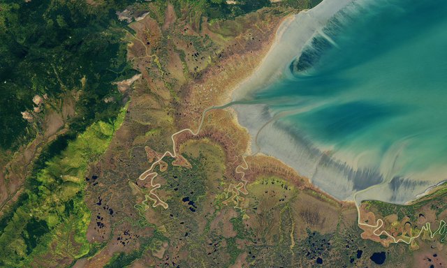
Ul'banskiy Bay, Russia

The Ulban Bay in eastern Russia seen by the NASA Landsat Satellite
Image credit NASA observatory
The Ulban bay in eastern Russia is often referred to as the “Bay of whales”. Here, the Bowhead and Beluga whales come to find food during the summer. As ice tends to stay until June, the waters are fairly untouched once it recedes. The whales then collaborate in driving fish into the freshwaters of the bay.
As you can see in the image, the area is not inhabited by people. Instead, lakes, rivers and marches are allowed to dominate the lower parts of the bay which quickly
What makes this image so beautiful to me is the different layers of colours, both in the sea and at land. On land, the colour of vegetation changes as the high difference in altitudes favours different types of trees. At sea, the early frost along the shore creates a grey colour fading into a lighter blue.
I highly recommend watching the image in its highest resolution here as it is truly spectacular.
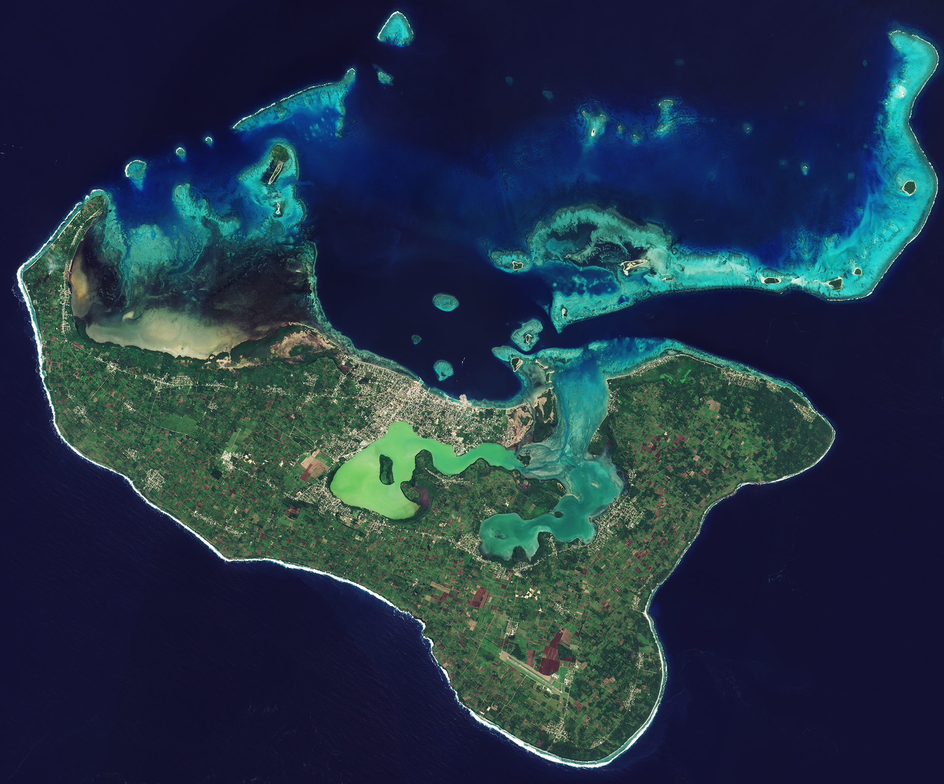
The island of Tongatapu, Tonga Kingdom

The Island of Tongatapu in the Toga Kingdom in the southern Pacific Ocean
Image credit ESA
The Tongatapu Island is the biggest of the 169 islands of the Tonga Kingdom. The kingdom is found south-west of Fiji and north-east of Australia and New Zealand in the southern Pacific Ocean. Roughly 70% of the Kingdom’s population lives on this main island. The Kingdom’s capital, Nukuʻalofa, can be seen at the centre of the northern coast, along the anga’uta Lagoon.
Looking closely at the island, you can see that much of it is covered by farms seen as numerous green rectangles. The island consists mostly of fertile soil on top of limestone and volcanic ash that stems from surrounding islands.
What makes the image so beautiful are the coral reefs to the north of the island. Satellites images are frequently used to study and monitor coral reefs like these to detect coral bleaching. These occur when algae is expelled from the reeves due to high temperatures in the water. With global warming, the bleaching occurs ever more frequently, threatening coral reeves like this with starvation.
This can have large costs to communities such as these, whose reef ecosystem is essential for fisheries, regional tourism and coastal protection.
Another thing worth noticing is how different the colours of the waters are. Ranging from green, to dark and light blue, to nearly black, all depending on the chemistry of the waters. Clearer waters reflect less light back into space, making them appear almost black in satellite images.
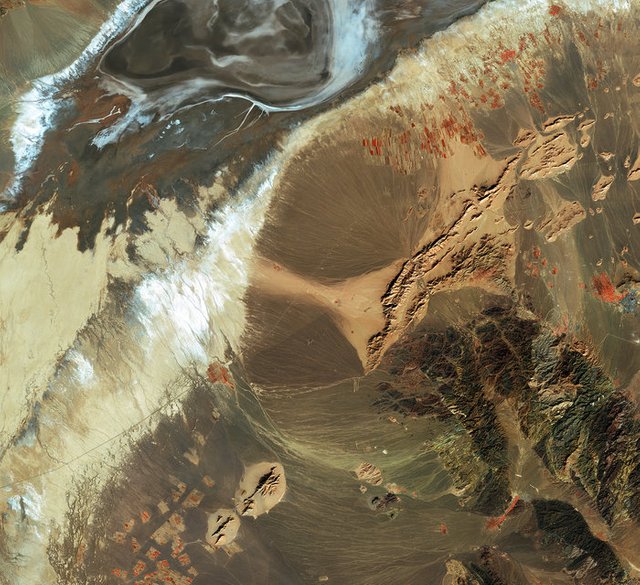
Bajestan, Iran

Bajestan in Northeastern Iran together with the surrounding mountains, barrens and farms
Image credit ESA
My favorite image of this round's satellite images is this 10-meter resolution image of northeastern Iran.
Although most of the image consists of barren lands, you can see the small city of Bajestan at the very right end of the image seen as a gray square. The red squares to the left of it, and scattered across the image, are farms. They appear red due to the false-color processing which adds an additional layer of color from the electromagnetic spectrum that is otherwise invisible to the human eye. As chlorophyll-rich plants emit more red light, vegetation turns red when this layer is added on top of the image, allowing us to quickly spot a number of farms scattered across the land, in particular to the north of the city and in the bottom left corner. The city also turns grayer as there is no color in that part of the electromagnetic spectrum reflecting off pavement and rooftops.
Most of the image is of mountains and barren lands, which is typical for an Iranian landscape. In the center and upper left corner of the image, you can see alluvial fans stretching out across the plains. These come about over time as streams of water flow down from the mountains and enters the flat plains. You see some stark differences in the colors of the landscape due in part to salts that are carried down with the streams and left in the fans.
I really love this image because of the way in which the stripes look almost like the strokes of a painting brush, giving the image the look of a painting, rather than a satellite image.
Want to try processing new satellite images yourself?
Most of the images in this series are taken by the European Sentinel satellites. Most images have also been processed by ESA, the European Space Agency. You can download the raw data from their satellite constellation yourself for free here, which can be processed professionally by the free and open source tool snap. You can also browse new satellite images online for free using the EO Browser.
Fredrik / @fredrikaa
You are right, the picture of The Tongatapu Island is really outstanding. I've just followed your advice looking at my own island on the EO Browser, and it's not that spectacular. However, it felt special seeing my home from the above :-)
I've seen a documentary about the Great Barrier Reef a couple of days back. They are also changing considerably due to the effects of global warming. It's terrible seeing such amazing places suffering that way and knowing that our way of living is one of the main causes for these changes.
Your content is really remarkable!
Resteemed
I'm very happy that you liked it, hearing it does mean a lot!:)
I absolutely agree! Living abroad I sometimes, when I get a little homesick, find the latest satellite image that we have available of my home town. Just to see the seasons come and go, the colour of the trees turn, the snow starting to cover the mountains, etc.
Yes, this is unfortunately why we do monitor these areas so closely with satellites, to observe and measure the effects of climate change. But I wish we did a whole lot more to actually prevent this from going off the edge rather than just observing and documenting as it does. :/
Again thanks a lot for the kind comment, and also for the resteem! It's a pleasure to sit down and produce these posts and I am happy to see that others share my love for it!
Wow.. Some of those pictures don't even look real they're so beautiful! At first glance I thought the first and third photos were abstract art.
Indeed they do ^^ I have had some on my wall, and people seeing them from a far often do ask what painter it is:P
So I can get a picture of my house at a bigger resolution than google earth? sweet! Although I'm trying to figure out how to use the explorer. Interesting tool.
The free data is lower resolution (usually 10 meter) so that is less than Google Maps. But you can get images that are only a few days old compared to Google maps which can be many years old.
True, I think some Google Earth images are even aircraft photographs, but I am not sure.
Absolutely beautiful pictures Fredrik!
Your job must be very interesting and motivating! If I was me in this job position and looking in to those picture, I will get the feeling that I have to go to those places :D
Thank you for sharing! Very beautiful post :) Upvoted!
Very happy to hear that you liked them @inuk ! :)
Yes the job is really cool, getting not only to see images like these, but even more so what we can do with the data when we have a new image of every corner of the world every single day :)
Haha yeah, I guess I don't need to have big expenditures on travel because I can just visit all the places with a satellite ^^ (not the same though :P)
Again happy that you liked it! Thanks for the upvote, altough the post was more than 7 days :<
Got the new post in the series out today though if you would like to see more!
Take care
Fredrik
We want Greece!
I'll have a look and see what I can do ;)
We really do live on a beautiful planet. Thanks for sharing!
These are so beautiful. The Earth is an incredible place and satellite imagery reveals just how magical our world is. Thanks for posting these and the delightful commentary. I upvoted this post. It is definitely worth it.
Nice info upvoted and hope you will also
They are like sci-fi movies images and I love their colors very much. These images give me excitement and adventures.
Nice work by you ....upvoted!!