Beautiful Satellite Images of our Planet you won’t believe are real #6
In my job at the European Space Agency, we look at what satellites can do for non-space sectors of society. Sometimes, however, you simply have to stop what you do and enjoy the majestic beauty of some of the images we get!
In this series, I share some of my favorite images I have come across in the last weeks together with a short explanation of what you are seeing in the image. I hope you will enjoy them!
Irrawaddy Delta, Myanmar
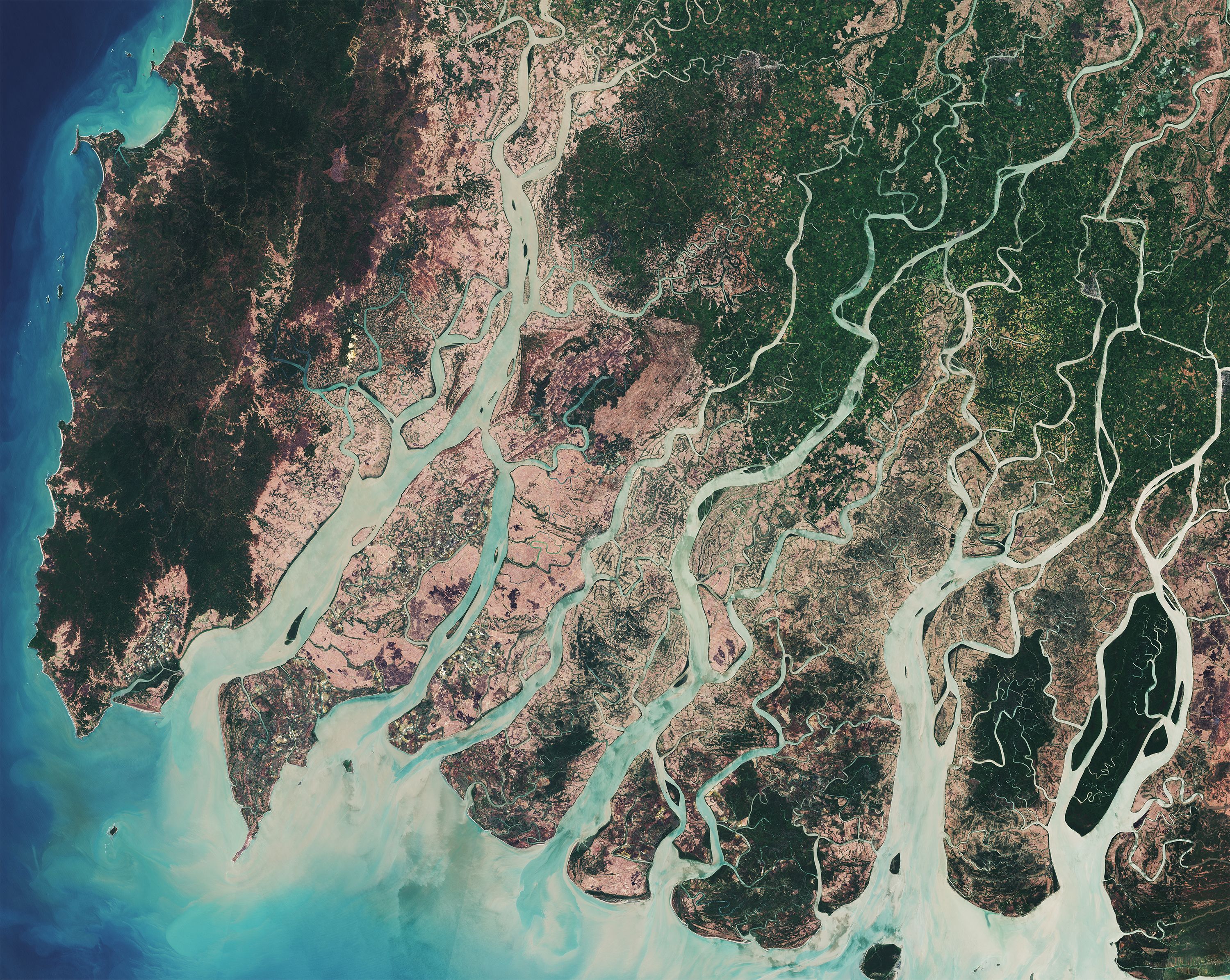
10 meter resolution image of the Irrawaddy Delta in south-western Myanmar by the European Sentinel 2A satellite image credit ESA
The Irrawaddy River is the largest river in Myanmar with an impressive length of more than 2200 kilometers, or about 5% the length of the Earth’s circumference. The river starts in the Northern part of Myanmar and runs through the central part of the country before fanning out into the Indian Ocean from the Irrawaddy Delta seen in this satellite image.
The image has a nice variety of colour due in part to the sediments that have been carried by the river and deposited in the delta, giving the waters its faint brown colour. This has resulted in an enrichment of the rich soils, making the lands here some of the most fertile in Myanmar, which is why you’ll find most of the country’s rice fields here.
This image was taken shortly after harvesting season before new seeds are planted. As a result, large portions of the landscape that you see have a very beige colour, giving it a stark contrast to the surrounding green forests. The woods here are dense mangrove forests, including the Mein-ma-hla Kyun Wildlife Sanctuary which can be seen at the lower right.
Tibetan Plateau, Nepal and India
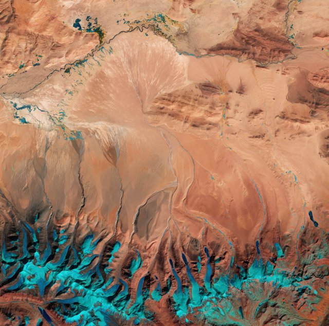
10 metre resolution satellite image of the southern Tibetan Plateau in Western Nepal and Northern India by the Copernicus Sentinel 2 satellite image credit ESA
This image takes us over the south-central parts of the Tibetan Plateau close to the border between Nepal and India. A continental collision 55 million years ago created the Plateau as the north-moving Indian continental plate collided with the Eurasian plate. The result of which has elevated these mountains up to an average height of more than 4500 metres covering a vast area, leaving the Tibetan Plateau as the highest in the world today.
As you can see in the image, large amounts of ice are stored here even though this image was taken in the summer. Indeed, the plateau is the third largest store of ice in the world following both the Arctic and Antarctic. However, the amounts of ice here have decreased rapidly in recent years due to increasing temperatures.
The lower parts of the image depict parts of the Himalayas. Here, you can see many blue lines of water running down the mountain side in smaller rivers that then fans out at the more levelled plains. The ice appears relatively blue due to a false-colour processing that has been done to more accurately spot snow and ice as compared to while clouds and parts of the landscape that would also appear white.
Alakol Lake, Kazakhstan
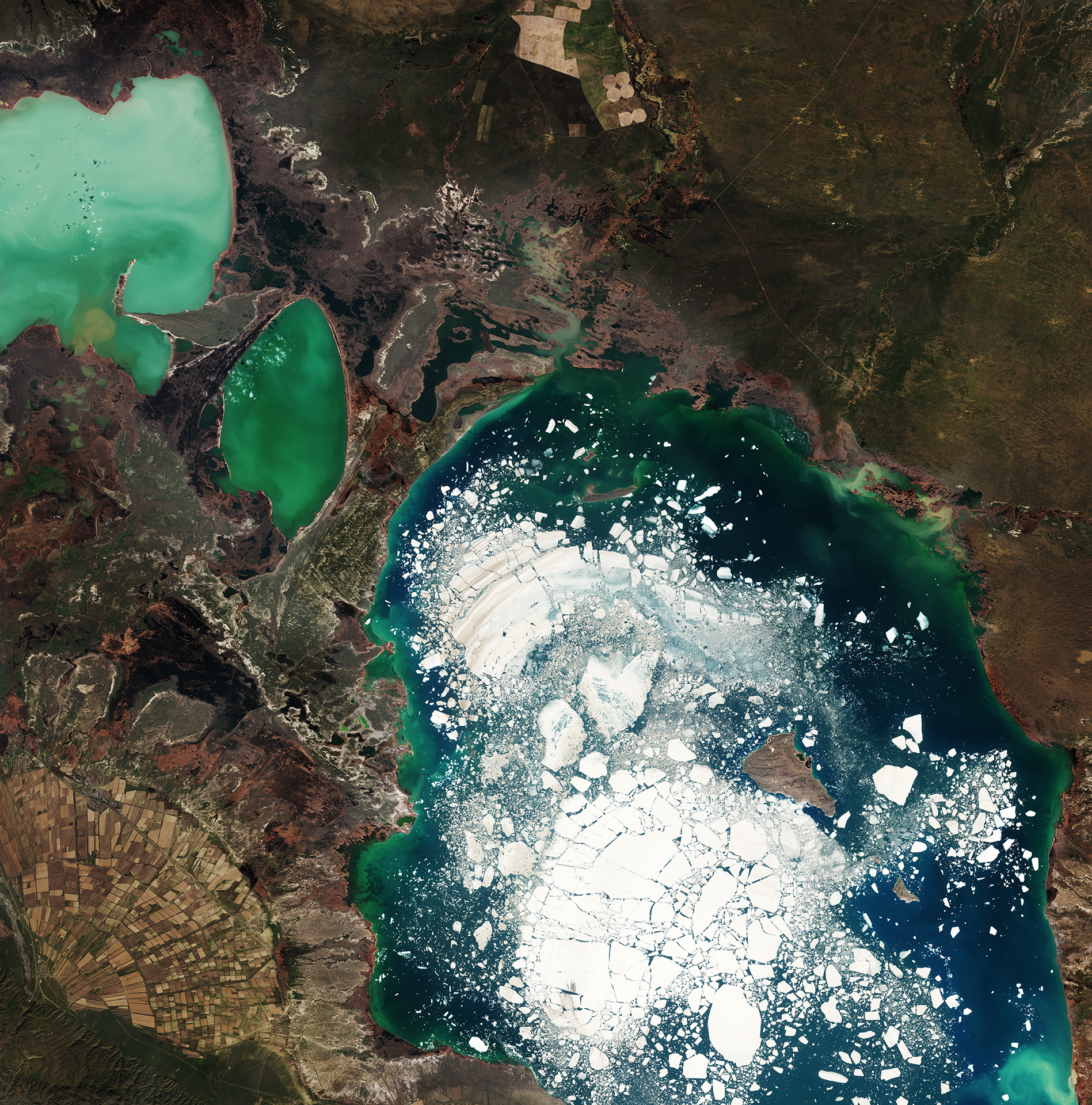
10 metre resolution satellite image of the Alakol Lake in Eastern Kazakhstan taken by the Copernicus Sentinel 2 satellite image credit ESA
This last image is of the Alakol Lake in Kazakhstan. The name literally translates into “multi-coloured lake”, a good fit with all the different colours of the lakes. These differences are due to the variety in the depth of the lakes, the types of sediments that have been carried down from the nearby mountains, and presence of phytoplankton. The lake is well known also internationally for its richness of different minerals. Indeed, many tourists visit this place believing that the waters and mud are therapeutic, and use the waters in the lake’s northern shores as a remedy for skin ailments.
The big chunks of ice that are floating in the lake sure add an extra level of beauty. Although the lake is salty, it still freezes completely for about 2 months during the year. As the image is taken in mid-April, the ice is slowing melting and breaking up following two months where the lake is completely frozen in the winter. A cool observation is how the water is blue surrounding the ice, but green near the land. The green colour is added by the phytoplankton, as green colour is reflected by plants rich with chlorophyll. As it takes higher temperatures for phytoplankton to bloom and gain a green colour, this has only began to occur away from the ice. Giving the lake both a blue and a green colour!
Another interesting observation is the shape of the agricultural area seen in the lower-left corner of the image. These farms lie just at the foot of the Dzungarian Alatau Mountain which begins just a bit further south east outside of the image. Just like in previous images, streams of waters have carried down large amounts of nutrition here over time, which creates an Alluvial fan when the waters flow out on the flat lands, making the soil is highly fertile in the process. These farms have been made right on top of the fan, making good use of what nature has already provided!
Want to try processing new satellite images yourself?
All images in this post were taken by the European Sentinel 2 satellites and have also been processed by ESA, the European Space Agency. You can download the raw data from their satellite constellation yourself for free here, which can be processed professionally by the free and open source tool snap. You can also browse new satellite images online for free using the EO Browser.
Fredrik / @fredrikaa
I cannot choose the best! Superb!
To me, it has to be the last one!
Just love how many different phenomena it covers worth spending some time understanding. From the waters, to the farms, as well as the stark differences in colour :)
Truly magestic views. Thank you for sharing them and the source. Following you now for more :)
I totally agree!
Very happy to hear that you liked it :) I expect to be continuing the series for quite some time and hope to see you around!
Absolutely beautiful! Thank you for sharing and telling us how to find the raw data - will have to check it out!
You're very welcome! I have many more to come ;)
Please do let me know if you play around with your new toys and come across something interesting!
More beautiful images. Is that blue color in the Napal image really ice?
Yes and no.
Yes it is ice. No it is not the "true" colour. I think I explained that we use a false colour processing technique to view light that reflects off snow as more blue to distinguish it from white clouds etc. This helps for snow-monitoring applications.
ahh, my apologies, I only skim read (short attention span lol)
whenever I see my country India on these types of places, I feel ecstatic and feel proud to be a part of My beautiful country. Thanx for sharing the beautiful pictures.
Indeed, seeing one's own country is quite unique and different. I have to admit that when I get a little bit homesick I do go and view my home town and its surrounding areas from a fresh satellite image :)
The Nepal pic is my favorite. It makes me think of a friendly Sarlacc from Star Wars for some reason.
Hahaha, that never struck me. but now that you say it, you're right! That's what I love about doing these series :) looking at the images takes your mind to different places ^^
You must have one of the coolest jobs a Norwegian can have, at least in my eyes :)

And thanks for the tip to to find raw data from the satellite. Will surly try to render som good pictures.
Hehe, yeah it is a real privilege to be able to get up and go work with something that I want to see more of in the world anyway, and not just because I have to :) My day-to-day work consists more of doing market research and the business cases for new use-cases for satellite data, and to help facilitate innovation knowledge transfer between regions and industries in Europe that can make use of new data and new satellite-based services. So it is not like I'm sitting and just looking at images all day :P
Cool to hear that you'll give the tools a try! Give me a shout if you manage to do something cool!
Second one looks like painting. I did not know about the coloring of ice blue before. Thank you for sharing! :)
If you think that one looks like a painting then just wait for another post I'm preparing :)
I have been saving those that are more "painting-like" than others for a dedicated compilation post of images that look like paintings :D
Congratulations @fredrikaa! You have completed some achievement on Steemit and have been rewarded with new badge(s) :
Click on any badge to view your own Board of Honor on SteemitBoard.
For more information about SteemitBoard, click here
If you no longer want to receive notifications, reply to this comment with the word
STOP