GUADALUPE Las Villuercas, Monfragüe and Sierra de San Pedro
Las Villuercas, Monfragüe and Sierra de San Pedro
GUADALUPE
Cáceres (Parque Natural)
Nearby destinations: Cabana and Montes de Toledo, Valle del Jerte la Vera.
The region of Las Villuercas extends from the Sierra de Guadalupe to that of Altamira.
In the east of Cáceres, on the dividing line of the two provinces of Extremadura.
On the other side of the mountain range, north of the Pico Villuercas (1,601 m) that gives its name to the region of La Solana.
The Ibor River is born, which travels a long way northward to deliver its waters to the Tagus in the reservoir of Valdecañas.
In the Solana de la Sierra, the Holm Oaks see Spring, after the winter rains, in the Guadalupejo River.
From the vicinity of the hermitage of Mirabel Mana El Silvadillas.
And the Sierra de la Palomera, north of Alia, the Guadarranque.
They all head south to pour their waters to the Guadiana dammed in the marsh of García de Sola.
The schists and slate rocks that compose these mountains generate poor soils but are well guarded by large Holm and gall.
Hunting is a secular activity and the mountains in the preserves are one of the axes of rural life.
The hunters flock to the deer, wild boar, fallow deer, partridges, hares, rabbits, quails and turtledoves.
As the winter touches its end, the cranes and the pigeons, which return to their breeding countries, leave the pastures.
The water is abundant thanks to the generous storms of the Atlantic that during the autumn and winter they reach their rains to the interior of Extremadura.
That's why Las Vegas and valleys have fertile soils where olive trees are grown,Chestnuts and vines for several thousand years.
In Fresnedoso de Ibor, the Descuernacabras River descends through a tortuous gorge towards the Valdecañas reservoir.
In the rocky cliffs of Juan Caldilla's Cancho, raptors and vultures occupy their spring days in bringing forth their broods.
Towards the east of the region, the port of San Vicente Salta the Sierra de Altamira that separates Cáceres de Toledo.
The Arroyo Guadarranque runs between Holm and Gall where the mongoose and the Lynx live.
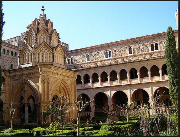
Guadalupe and the Black Virgin
In Guadeloupe, the monastery and its urban ensemble have been declared a World Heritage site.
Behind the wide arches of the bridge over the Guadalupejo, the poplars planted on the riverbank rise above the crushed hills around, cultivated with olive trees and vineyards.
The hermitage of Mirabel or the castles-farms of Mirabel and valdefuentes offer small excursions to admire the marcear of the Triwales and fields of labor under the flowered Holm Oaks.
In the more embedded narrows and valleys, humidity and thermal stability favor the growth of the Ferns-
And there are even sections where evergreen shrubs like laurel, Holly and Madroños, along with subtropical ferns.
Monfragüe and the Corchuelas
MonfragüeAl to sneak between the Sierras that separate in the heart of Cáceres the towns of Plasencia and Trujillo.
The Tagus River crosses a forgotten territory for centuries that has preserved the integrity of the Mediterranean landscape in its multiple variants.
It is the natural park of Monfragüe.
Despite the clarity of the days and the intensity of the night frosts.
The Sierra de las Corchuelas attends an early riser to awaken the Holm oaks in its veranda.
The daffodils, the orchids and the primroses more early flourish.
The black vultures, the Imperial eagles, the Lynx and the mongoose take care of their offspring.
The Cañada Real Trujillo starts here its layout.
By it they pass in May the herds of merino.
Only the bridge of the Cardinal allowed in the past to wade the river Tagus for centuries, just where it receives the waters of the Tiétar.
Today the road borders a river regrown by a distant prey.
At the confluence with the Tiétar, the Tagus tired of plotting meanders and split the saw in two.
On the right bank he left what we know today as Sierra de Santa Catalina.
With its eastern spur, La Peña Falcón, which precipitates vertically over the channel in the Gypsy's jump.
The left bank the Sierra de las Corchuelas appears crowned from the High Middle Ages by a defensive castle, now in ruins.
In the Umbria of the Corchuelas, to travel along a path that ascends from the road to the castle.
They regain their splendor renewed the trees of wide, shiny and always green leaves.
They also sprout the gall and the cork oaks flourish, some of them years and stout as the most.
The ruins of the castle and the Hermitage offer a perfect vantage point from which to admire all the natural space.
With the Tajo dammed at its feet and the cliffs of the Gypsy's jump where the vultures and the Black stork breed.
Villarreal, across the river.
The Chozos of slate and roof of piorno or broom try to keep alive an aspect of the human landscape of yesteryear.
When there was no dam and road and these Sierras were only frequented by merino and pastors in transit.
Herds Gorrinos in Montanera and nobles with shotgun to shoulder.
The Sierra de San Pedro
To complete the tour through the heart of Extremadura.
For its meadows or evergreen woods, you have to go to the western end.
Where Badajoz is prolonged to the northeast bordering Portugal.
In the Sierra de San Pedro, around Alburquerque and the Sierra de Alcantara.
The Extremaduran Wolves take refuge there.
They are sheltered in the most hidden holms and thickets.
The cork oak forests are extensive as well and in them the cork is the most profitable resource along with the hunt.
Focusing on the economic activity of the region.
In these productive forests are abundant the pairs of real eagle, of black Vulture.
The populations of black stork, lynx and Mongoose, the most emblematic vertebrates of the Mediterranean forest landscape.
Several castles that served as watchtowers on the Borders Hispano Lusitanas now allow you to enjoy wide views over the Sierras.
And narrows that rivers like, for example, the Zabatán have dug in the mountains.
Albuquerque's own town spreads at the foot of a monumental castle.
A local road leads north through the mountains to cross the livestock road that comes from the west.
So you can access the castle of Piedrabuena.
MonfragüeContinuando to the north you reach the Peña Manzano, another interesting oteadero.
Next to the abandoned railway station of Herreruela, the hermitage of San Pancrazio is reached.
Azagala Castle is lost upstream from Peña del Águila Reservoir.
To get to him you have to follow the track that runs through the Sierra del Puerto del Centinela to the east of Alburquerque.
Around Valencia de Alcantara-
The abundance of dolmens justifies entering a few kilometres in ' lands to visit the megalithic monuments.
Built by the cattle tribes that populated these lands five or six thousand years ago.
Its large stone slabs lie 2 km east of the village, next to the C 530, to the west around the hamlet of La Vega.
Very close to the border with Portugal, and also to 8 km to the south, around Areña of the winery.