Yellowbird Flying Above the San Luis Valley
This is a cool aerial image I lensed of my friend Duke Phillips a.k.a. "The Flying Cowboy" in his Husky A1B Bushplane flying above the Zapata Ranch that he manages in the San Luis Valley in the high desert of the Colorado Rocky Mountains.
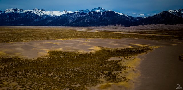
This is the San Luis Valley in southern Colorado, in the background are the mountains of the Sangre de Cristo (Spanish for "Blood of Christ") the southernmost subrange of the Rocky Mountains. This range runs from Poncha Pass in South-Central Colorado, trending southeast and south, and ends at the Glorieta Pass, just southeast of Santa Fe, New Mexico.
This range used to be called "La Sierra Nevada", "La Sierra Madre", "La Sierra", and "The Snowies" (used by English speakers). In 1719 the Spanish explorer Antonio Valverde y Cosio named the range Sangre de Cristo ("Blood of Christ") mountains after being impressed by the reddish hue of the snowy peaks at sunrise, alpenglow.
On the right side of this image is Mount Herald with its 13340 ft / 4066 m peak. Below this is the Great Sand Dunes National Park, containing the tallest sand dunes in North America which rise to a maximum height of 750 feet / 229 m, from the floor of the San Luis Valley on the western base of the Sangre de Cristo Range. The dunes cover an area of about 19,000 acres / 7,700 ha.
Researchers say that the dunes started forming less than 440,000 years ago and were created from sand and soil deposits of the Rio Grande and its tributaries, flowing through the San Luis Valley. Over ages, the glaciers that fed the river and vast lake that existed across the valley melted away, and the water evaporated. Westerly winds picked up the exposed remaining sand particles from the dry lake and river flood plain.
As the wind eventually lost power prior to crossing the Sangre de Cristo Range, the sand was deposited on the east edge of the valley, creating the piled up dunes we see today. This process still continues, and the dunes are slowly growing. The wind changes the shape of the dunes daily as it continues to move sand from the middle of the valley northward. (Research Source)
Behind the dunes there is a small creek that runs through that pass to the left of Mount Herald, this is called Sand Creek . In the pass there is a small but pointed peak sticking up in the distance right below the clouds on the horizon, that is Blueberry Peak.
Following the ridgeline and continuing up to the left is Cleveland Peak 13,420 ft / 4091 m. Immediately to the left of that is Tijeras Peak at 13604 ft / 4146 m. This is followed by Music Mountain at 13380 ft / 4078 m and then Pico Asilado at 13611 ft / 4148 m.
Further to the left is Broken Hand Peak at 13573 ft / 4137 m, Broken Hand was named for one the West’s most famed mountain men and fur trappers, Thomas “Broken Hand” Fitzpatrick, an important figure in the fur trade and westward exploration of the mid-1800s. He led two wagon trains on the Oregon Trail and negotiated one of the biggest agreements with the First Nations Tribes at the time, the Fort Laramie treaty of 1851. He had acquired his nickname early in his career when a rifle misfired and exploded, crippling his left hand. The moniker “Broken Hand” was bestowed on him by the Nez Percé. (Research Source)
Moving on to the left along the mountain tops we next come to venerable Crestones, a cluster of high summits in the Sangre de Cristo Range, here we have Humboldt Peak at 14064 ft / 4287 m, and then Crestone Needle at 14197 ft / 4327 m and Crestone Peak at 14294 ft / 4357 m.
And to the far left we have Columbia Point at 13980 ft / 4261 m, then Kit Carson Mountain at 14165 ft / 4317 m. This was named after the famed pioneer and explorer Kit Carson.
And finally the last large mountain on the far left of this image is Challenger Point at 14081 ft / 4291 m. The summit is on the northwest shoulder of Kit Carson Mountain, and is a subpeak of the latter. It was renamed in memory of the seven astronauts who died when the Space Shuttle Challenger disintegrated shortly after liftoff on January 28, 1986.
In the middle of this image can you see Duke Phillps (the Flying Cowboy) flying his bright yellow Husky bush plane above the golden dunes? Open it up full screen to see it all!
This is from my ongoing project in which I am trying to raise awareness of the 47% of the USA and 90% of Canada that remain unpopulated wilderness.
Where Eagles Fly - The American Wilderness Expedition is my personal mission to introduce people to these amazing locations that surround us.
If you are interested in helping with this project I would love to have your assistance! Please consider upvoting and resteemit so that others may experience these wondrous places as well.
Yehaw!!
Nice photo and nice explanation.
Thanks!
Beautiful shot!
Very kind of you!
beauty of nature i took a pic of sun rising u would love that ;)
@skypilot Amazing! I am coming on your wall, well done and bwst shot dude. You have Beautiful photos are nice views, while good photos that fit the target. In my opinion, it takes a "Wow Effect" to make our work memorable. "Wow effect is needed to make a good photo more talk. Good job and well done. You've presented a photo representing both of them. An amazing photo result. Don't to visit my blog for my latest post
Now remain calm!!! LOL wow your enthusiasm is contagious! Very cool, glad you like it so much! Wait till you see what I have planned for the future. This project will continue for a few years to come. And I plan on remaining a part of the Steemit community through the full expedition. yehaw!!
@skypilot Amazing! I am coming on your wall, well done and bwst shot dude. You have Beautiful photos are nice views, while good photos that fit the target. In my opinion, it takes a "Wow Effect" to make our work memorable. "Wow effect is needed to make a good photo more talk. Good job and well done. You've presented a photo representing both of them. An amazing photo result. Don't to visit my blog for my latest post
I lived in Colorado for years. There's no other place quite like it!
True That!!
Nice... I have 4 acres in Villa Grove, CO or Moffat depending on who you talk to... which is in the San Luis Valley. It is a mystical place.
It is indeed! I love that entire area and fly in to see my buddy Duke at the Zapata Ranch every so often.
GREAT
Beautiful location and special place to catch visually.