भारत की वैज्ञानिक उन्नति [ ईशा पुर्व ] Scientific advancement of India [BCE]
If you are a South Asian, you should read it to know our glorious history.
यदि आप दक्षिण एशियाई हैं, तो आपको हमारे गौरवशाली इतिहास को जानने के लिए इसे पढ़ना चाहिए।
नमस्कार steemit साथियों
आज हम एक ऐसे विषय पर चर्चा कर रहें हैं, जो ये बात साबित करती हैं, कि भारत ने उस समय में इतनी वैज्ञानिक उन्नति कर ली थी, जब विश्व की अन्य सभ्यतायें अपनी प्रारम्भिक अवस्था में थी।
हम सभी जानते हैं, आज का विज्ञानं अभी तक ग्रहों और तारामंडल के सभी रहस्यों को खोजने में जुटा हुआ हैं। जबकि हमारे ऋषि मुनियो ने हजारों साल पहले खगोल के सभी रहस्य खोज लिए थे तथा प्रत्येक ग्रह और नक्षत्र की चाल का सटीक विश्लेषण कर लिया था। तभी तो भारत का ज्योतिष शास्त्र आज भी विश्व का सबसे उन्नत गणितीय व् वैज्ञानिक विश्लेषण हैं।
इसी प्रकार पृथ्वी की गोलाकार आकृति और चाल की सटीक जानकारी हमारी सभ्यता को बहुत पहले से ही थी। इसका एक पुख्ता प्रमाण --
भारत में कुल १२ ज्योतिर्लिंग हैं। उनमे से पहला ज्योतिर्लिंग हैं ' सोमनाथ ' , सोमनाथ मंदिर भारत के पश्चिमी समुद्री तट पर स्तिथ हैं। विशाल अरब सागर हमेशा भगवान भोलेनाथ के चरण पखारता हैं। ज्ञात हजारों वर्षो के इतिहास में एक बार भी समुद्री तूफ़ान अथवा अन्य बाधाओं ने इस मंदिर को नुकसान नहीं पहुंचाया। जबकि समुद्री तट पर बसे एक भी देश, शहर या धार्मिक स्थल के बारे में विश्वभर में कोई उदाहरण नहीं होगा, जो समुद्र किनारे बसा या बना हुआ हो और समुद्री सुनामी, तूफ़ान से प्रभावित हुए बिना रह गया हो।
' कुछ तो ऐसा हैं ,जिसके कारण समुद्र अपनी मर्यादा नहीं लांघ पा रहा हैं। इसे हम आश्चर्य कहें, संयोग कहें अथवा वैज्ञानिक विलक्षणता या ,भगवान भोले नाथ की शक्ति।'
एक और बहुत ही आश्चर्यजनक अनुभूति, जो हमने सोमनाथ मंदिर प्रांगण में देखी। यदि आप सोमनाथ गए हैं तो आपने भी अनुभूत किया होगा, या ध्यान नहीं दिया होगा। जब भी सोमनाथ जाएँ इस तरफ जरूर ध्यान दीजियेगा --
मंदिर प्रांगण में एक 'बाणस्थंभ' हैं। प्राप्त तथ्यों के अनुसार ये लगभग पंद्रह सौ (१५००) वर्ष पुराना हैं। इसको ध्यान से देखते हैं, तो हमे घोर आश्चर्य होता हैं। साथ ही गर्व भी होता हैं अपने आप पर कि हम एक ऐसी सभ्यता का हिस्सा हैं, जो न सिर्फ आर्थिक, सामाजिक, भौतिक और व्यापारिक रूप से उन्नत थी, बल्कि वैज्ञानिक रूप से भी इतनी उन्नत थी कि बिना किसी वैज्ञानिक उपकरण के इतनी बड़ी खोज कर ली, जो आज का विज्ञानं अभी तक नहीं कर पाया और करने लगे तो इतने उन्नत उपकरणों के होते हुए भी सम्भवतया बहुत समय लग जाये।
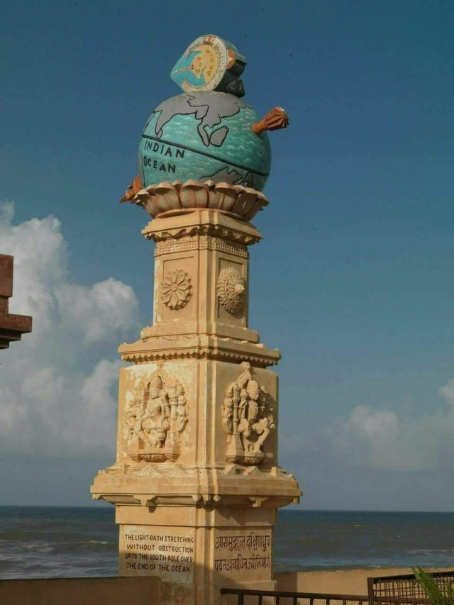
इस चित्र में जो स्तंभ दिखाई दे रहा हैं, ये दिशासूचक हैं। ऊपर एक तीर बना हुआ हैं, जो कुछ इंगित करता हुआ सा प्रतीत होता हैं। जब जिज्ञासा बढ़ी, कि ये क्या इंगित कर रहा हैं, तो हमारा ध्यान इस स्तंभ पर लिखे हुए संस्कृत पंक्ति की तरफ गया।
'आसमुंद्रांत दक्षिणध्रुव पर्यंत अबाधित ज्योतिर्मार्ग '
अर्थात बाणस्तंभ के बाण बिंदु से सीधी रेखा में बाण बिंदु से लेकर दक्षिणी ध्रुव [ अंटार्कटिका ] तक निर्बाध जल मार्ग हैं। यनि इस बिंदु से दक्षिणी ध्रुव तक कोई भी बाधा नहीं हैं।
समुद्री मार्ग में बाधा स्वरूप कोई महाद्वीप, द्वीप अथवा जमीन का टुकड़ा होता हैं, जिनसे बचते हुए जहाजों को समुद्री मार्ग पर बढ़ना होता हैं।
हमे आश्चर्य इसी बात का हैं, कि लगभग १५०० वर्ष पुर्व हमारे पूर्वजो ने इस निर्बाध समुद्री मार्ग की खोज कैसे की होगी। आज के युग में तो सेटेलाइट हैं। हवाई जहाज हैं तथा अन्य बहुत से उपकरण हैं, जिनसे इस मार्ग का पता लगाया जा सकता हैं, पर उस समय तो ऐसा कुछ भी नहीं था।
हमने इसकी सत्यता को जानने के लिए गूगल मैप का सहारा लिया। हमने मैप को ज़ूम करके कोशिश की [ हालाँकि ये बहुत ही उबाऊ और थका देने वाला काम था ] पर हमे इस बीच में एक भी भूखंड नहीं मिला। कम से कम १० किमी गुणा १० किमी से छोटा गूगल मैप पर देख पाना सम्भव नहीं था।
बाण स्तंभ के यहां होने के ईस्वी सन् छह सौ से तो लिखित प्रमाण उपलब्ध हैं। पर सम्भवतया ये उससे बहुत पहले का हैं। हम इसको छठी शताब्दी का भी मान ले तो,उस समय हमारे पुरखों को ध्रुवों का और इतने लम्बे जल मार्ग का ज्ञान कैसे हुआ होगा , कि इस मार्ग में एक भी भूखंड नहीं पड़ता।
कैसे की होगी उन्होंने इतने लम्बे जल मार्ग की मैपिंग ?
मैपिंग को कार्टोग्राफी कहा जाता हैं। मैपिंग की शुरुआत का श्रेय 'एनेक्झीमेण्डर' ग्रीक वैज्ञानिक को दिया जाता हैं। इनका कालखंड ६११ ईशा पूर्व से ५४६ ईशा पूर्व था। इनका बनाया हुआ मैप अत्यंत प्राथमिक स्तर का था। मैप के वर्तमान स्वरूप का श्रेय हेनरिक्स मार्टेल्स को जाता हैं, जो लगभग १४९० ईश्वी सन के आसपास का हैं। ये भी माना जाता हैं, कि कोलंबस ने इसी मैप के आधार पर समुद्री सफर तय किया था।
लेकिन भारत ने ६ वी शताब्दी में यहां से अंटार्कटिका तक का सटीक समुद्री मार्ग खोज लिया था।
लगभग ईशा पूर्व ३८४/३२२ एरिस्टोटल ने पहली बार पृथ्वी के गोल होने की अवधारणा रखी। सम्भवतया उस काल में उनकी इस धारणा को स्वीकारना तो दूर, कोई मानने तक को तैयार नहीं था। पर भारत में इससे भी पहले पृथ्वी की आकृति और ग्रहो की चाल का सटीक विश्लेषण ज्योतिष शास्त्र के रूप में सर्वमान्य था।
५ वी शताब्दी में तो भारत के महान योगी आर्यभट्ट ने पृथ्वी का व्यास ४९६८ योजन [वर्तमान में ३९९६८ किलोमीटर ] बता दिया था। अत्याधुनिक तकनीक से पृथ्वी का व्यास ४००७५ किलोमीटर बताया जाता हैं। ५ वी शताब्दी के आर्यभट्ट के विश्लेषण और वर्तमान के वैज्ञानिक विश्लेषण में मात्र ०.२६ % का अंतर् आ रहा हैं।
सन २००८ में जर्मनी के विख्यात इतिहासविद जोसेफ श्वार्ट्सबर्ग ने ये साबित किया था कि ईशा पूर्व दो - ढाई हजार वर्ष पहले भारत में नकाशा शास्त्र बहुत ही विकसित था। उस समय भारत में नगर रचना के तथा नौकायन के लिए आवश्यक मैप उपलब्ध थे।
जिस प्रकार सम्पूर्ण दक्षिणी एशिया में हिन्दू संस्कृति के चिह्न आज भी विद्यमान हैं, उसी प्रकार सम्पूर्ण विश्व के तत्कालीन संस्कृतियों से भारत के व्यापारिक संबंधो के अवशेष मिलते हैं।
मेरा ये विश्लेषण अनेक तथ्यों पर आधारित हैं। आप भी इन सबसे परिचित होंगे ही, यदि आपकी रूचि इतिहास को जानने में रही हैं तो।
Hello steemit companions
Today, we are discussing a topic that proves that India has made so many scientific advances in that time when other civilizations of the world were in their initial state.
We all know, today's science is still gathering to discover all mysteries of planets and constellations. While our sage Munio had searched all the secrets of Astro thousands of years ago and accurately analyzed the movements of each planet and constellation. At that time, India's astrology is still the world's most advanced mathematical and scientific analysis.
Similarly, accurate information about the circular shape and movement of the earth was very important to our civilization. A substantial proof of this -
There are 12 Jyotirlingas in India. The first of which is Jyotirlinga 'Somnath', Somnath Temple is situated on the western coast of India. The vast Arabian Sea always pays the steps of God Bholenath. In the history of thousands of years, sea storm or other obstacles have not damaged this temple once. While there will be no example of a single country, city or religious place on the seashore, which remains or is situated on the seashore and the Marine Tsunami remains without being influenced by the storm.
'Something like this, due to which the sea is not able to stretch its limits. Tell us this, say a coincidence or a scientific extravaganza, or the power of Lord Bhole Nath.
Another very amazing sensation, which we saw in the Somnath Temple premises. If you have gone to Somnath then you would have either strayed or not paid attention. Whenever Somnath goes, you will pay attention to this.
There is a 'Banthastha' in the temple premises. According to the facts received, these are approximately fifteen hundred (1500) years old. If we look at it carefully, then we are very surprised. At the same time, pride is also on ourselves that we are part of a civilization that was not only economically, socially, physically and commercially advanced, but also scientifically so advanced that such a great discovery of a scientific instrument If you do not have the science of today and have started doing so, it may take a lot of time, despite having such advanced equipment.
The pillars that are visible in this picture are directional. An arrow is made up, which seems to be a bit pointing at. When the curiosity increased, that is what it is indicating, then our attention went towards the Sanskrit line written on this pillar.
'Ausamundruta Abhaya Jyotirang till South Dhruva'
That is, there are uninterrupted water routes from the arrow point in the straight line to the southern pole [Antarctica] from the arrow point of the arrowhead. That is, there is no obstacle from this point to the South Pole.
There is no continent, island, or piece of land in the way of obstruction in the sea route, from which the ships avoiding them have to move on the sea route.
We are surprised that how our ancestors searched for this uninterrupted sea route by about 1500 years ago. In today's era there are satellites. There are airplanes and many other tools, to which this path can be traced, but at that time there was no such thing.
We used Google Maps to know its authenticity. We tried zooming the map [although it was a very boring and tiring work] but we did not find any plot in the meantime. It was not possible to see at least 10km in 10km smaller than Google Maps.
Written evidence is available from sixty-six hundred to be here in the arrow column. But this is probably too long ago. If we also accept this from the sixth century, how would our ancient fathers have knowledge of the poles and such a long water way, that there is no single plot in this path.
How would they be mapping of such a long water route?
Mapping is called cartography. The introduction of mapping is given to the Greek scientist, 'Anneximander'. Their era was 546 Isha predictions from 611 Isha East. The map made of them was of very basic level. The present form of the map goes to Henriques Marsells, which is around 1490 Ishya Sun. It is also believed that Columbus had traveled by sea on the basis of this map.
But India discovered the exact sea route from here in the 6th century to Antarctica.
Approximate Isha pre 384/322 Aristotle conceived the idea of getting Earth's goal for the first time. Perhaps in accepting this assumption in his lifetime, he was not ready to accept it far away. But even before India, the exact analysis of the shape of the earth and the movement of the planets was valid as astrology.
In the 5th century, the great yogi of India, Aryabhatta, told the diameter 49th plan [currently 3,668 km] of the earth. With cutting-edge technology, the diameter of the Earth is said to be 40075 kilometers. Analysis of 5th century Aryabhatta and the present scientific analysis of 0.26% is coming in.
In 2008, the famous German historian Joseph Schwartzberg had proved that map science was very developed in India two and a half thousand years ago. At that time there was a map available for urban construction and sailing in India.
Just as the icons of Hindu culture in entire South Asia exist today, in the same way, then the remains of India's business relations are found from the entire world cultures.
These analyzes are based on many facts. You will also be most familiar with this, if you are interested
If we believe in any religion, resident of any southern Asian country, then we should be proud of our glorious history.
We are proud of the fact that the great powers and sciences of the world today are being appreciated by the inventions we had done thousands of years ago.
Our misfortune is that they were given credit to those who searched or copied them all later.
You are requested to comment on this post and make me aware of your thoughts. If you like, you can also upvote.
हम किसी भी धर्म को मानते हैं, किसी भी दक्षिणी एशियाई देश के निवासी हैं, तो हमें अपने गौरवशाली इतिहास पर गर्व होना चाहिए।
हमें इस बात का गर्व हैं , कि विश्व की महान शक्तिया और वैज्ञानिक आज जिन आविष्कारों पर गौरान्वित हो रहे हैं, वो हमने हजारो वर्ष पहले ही कर ली थी।
हमारा दुर्भाग्य ये रहा कि इनका श्रेय उनको दिया गया, जिन्होंने इन सब को बाद में खोजा या नकल किया।
आपसे निवेदन है, कि इस पोस्ट पर टिप्पणी करके अपने विचारों से मुझे अवगत कराये। पसंद आये तो अपवोट भी करें।
yours - indianculture1
Great information thanks for sharing.
Thanks Raksha
Posted using Partiko Android
Proud to be indian, great information.
Posted using Partiko Android
Thanks Amrut
Posted using Partiko Android
You got a 5.54% upvote from @postpromoter courtesy of @indianculture1!
Want to promote your posts too? Check out the Steem Bot Tracker website for more info. If you would like to support the development of @postpromoter and the bot tracker please vote for @yabapmatt for witness!