The real work and imagination of Bangabandhu satellites
There is a lot of debate on the issue of providing adequate information from Bangabandhu satellite launch and due to the lack of proper coverage of those information. Confusion has happened. In particular, some confusion was made on the work of the first Bangladeshi artificial satellite Bangabandhu Satellite-1 (BS-1). Many BS-1s wanted to do all types of satellites because they did not have any idea about different satellites. The satellite designed for communication purposes will do the work of communication. Weather forecasts, geological surveys, photographs, map-making, and climate change surveys are done by different satellites. In this context, we have been trying to negotiate the BS-1 capabilities in technical terms.
The use of Transponders for the discussion of BS-1 revenue earnings is remarkable. First of all, learn a little about Transponders.Transceiver, Repeater, and Transponders in communication
Transponder (transmitter-rescondor) receives signals from any source and amplified them or amplified them back in such a way that a large number of customers may receive that signal or signal. Transponders are much like a TV or radio relay station, which simultaneously broadcast many channels. In Satellite Communications, a group of transponders transmits a different frequency set from Earth to the sub-satellite link and takes a wave band in the down link to the Earth. Depending on what work is being given, Transponders can combine different types of work. For example: Location service, distance measurement works.Tech Properties of Bangabandhu Satellite-1
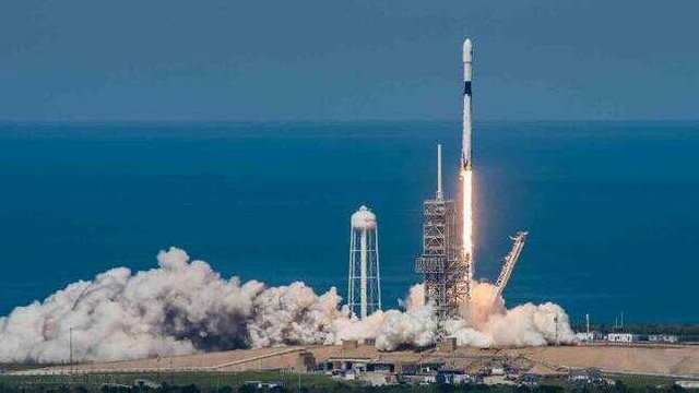
The Thales Alenia Space Company was responsible for the preparation, preparation, examination and launch of the technical design of Bangabandhu Satellite. Its lifetime is 15 years and the main work is TV broadcast, VSAT and DTH.
The BS-1 satellite is equipped with 26 KW bands and 14 C band transponders, from the position of 119.11 East longitude orbit. Under the KY band, Bangladesh, India, Nepal, Bhutan, Sri Lanka, the Philippines and Indonesia region, along with its water resources in the Bay of Bengal. All these areas will be covered under the C band. It is to be noted that since Bangladesh is located at 90.44, it is not possible to cover the land and water bounds of the geographical satellites (optimum coverage) in the orbit of 119.2 East longitude (optimum coverage); Rather, the Indo-Filipino region will get its high quality.According to Thales, BS-1 can provide the following threshold services subject to the completion of In-Orbit Test (IOT):
- DTH (Direct to Home) - Multiplexed Digital Television, Radio and Related Data, which will be provided directly in very small radio antennas.
- Video Distribution-Multiplexed Digital Television, Radio and Related Data, which will be provided in the medium radio antennas.
- VSAT Private Network - Provides a private network with voice, data and internet services, which will be provided through the medium radio antenna in banks, gas stations etc.
- Broadband-remote and user (individuals or organizations) will offer high speed Internet access.
- Communication trunk-wide band will provide high-power point-to-point data services.Note that you will need to create a separate satellite phone operator for the above mentioned 4 and 5 services. Its user terminals (which we call mobile) are laptops size or larger. Many global companies offer this emergency service in just three or four satellites around the world, which are usually useful in disaster or remote areas. Earthquakes, tsunamis, and even floods and global flood relief firms are seen using these sat phones. However, since Bangabandhu Satellite is a Geostationary Orbitt Satellite (located approximately 35 thousand 786 kilometers away from the user), its voice and data communications have significant duration of time difference (latency or delays), which can be given by the normal commercial terrestrial telescope with high voice and data reception. No Although there is more bandwidth than the low Earth Orbit or Leo satellites, due to high latency, sustainable servicing of 60 to 522 kbps is possible. As a result, Bangabandhu Satellite is basically Digital TV Broadcasting, Radio Broadcasting and VSAT Satellite. That is, Bangabandhu-1 satellite is a communications satellite, which will provide emergency telecom services in a limited range, with some conditions fulfilled.Various artificial satellites used for various purposes
There are various satellites outside the satellite and communication satellites, which are engaged in special functions such as Space Observations, Astronomy, Meteorological Meteorology (Weather and Atmospheric Study), Special Research, Specialized Telecommunications, Navigation, Search and Rescue, Remote Sensing etc. . However, it is being said that this special artificial satellite is equipped with special hardware. Transponder is in communication satellites, as well as on the weather satellites, radio meters (radiation measurement instruments), scatterometer (various gas in the atmosphere of the Earth, such as: carbon dioxide, ozone, nitrous oxide, etc.), lighting imaging (electricity flare monitor) Done) etc. Apart from this, there are various types of monitoring instruments and cameras called Spectrometer (electromagnetic wave study monitor), ultimeter (measured in height and space dispersion) and so on.Unfair expectation pressure or very encouraging campaign! - Bangladesh's Direct-to-Home (DTH) service adds a great dimension to the satellite. Cable TV's triumph in the country is not available here, the satellite TV or Disable TV business is not widely available here. Since cable TV is dragged into hundreds or thousands of miles of cable wire line, it is administrative in the head over the city street or underground space management, so cable broadcasts have to stop.
Since Bangladesh is located at 90.44 long, so there are no land and water bodies in Bangladesh under the favorable geostationary satellites (ground satellites) in the orbital position of 119.2 degrees east. As a result, the Bangladeshi TV broadcasting companies have been forced to prove that the air quality is piloted especially during rain, fog and storm. On the other hand, since currently TV stations are already contracting long-term contracts with outside satellite broadcasting companies and not all tech instruments run by the DTH system, hence the prospect of being dependent on BS-1 is also unjustified.On the contrary, very high coverage can be found in the Indo-Filipino Territory, the newly formed Bangladesh Communication Satellite Company Limited (BCSCL) will be able to find potential customer-buyers in the region faster. In other countries, such commercial arrangements have been made before the launch of a communication satellite. It has not happened to us.
Besides, BS-1 will open the way to create a 'VISAT' private network. It will open the way to create a private network with voice, data and internet services, which are absent from the banks, gas stations, different industries etc in Bangladesh. We hope BCSCL will look at this new VSAT-centric revenue from the Far Eastern Indo-Filipino zone outside the country and the country. - There may be discussions about how to deal with situations like flooding, storms, or Sidr, especially in distressful disaster management, or how BS-1-centric satellite users and terminal phones or laptops can be used to communicate relief and rescue workers in earthquake situations. Since global companies are already providing this service with special artificial satellites, there is enough set of sat phones or satellites installed in Haiti, Christ Church, Sichuan, or Italy, keeping costs aside. On the other hand, the Wakatiya service of Bangladesh's forces can be used for this purpose. Outside, telecom's emergency service provision has to be left. So it is worth seeking a cost-effective and sustainable solution by pulling unnecessary costs.3. Bangabandhu satelite photography, image processing, measuring the flood situation, determining the height of the water, the weather forecast, the distance measurement, the navigability and direction of the river, the contraction of wetlands, the efficient digital maps, the Earth Observatory, and climate change can not be done. There are different specialized artificial satellites for this.
Buena toma, Saludos. te anexo a mi circulo de amigos.. gracias por compartir la publicación.