To the Roof of Liberia
“I'm down at parking and the guy here says car is the way to go, should be 5 hours the way the road's looking," I relayed to Dan, a former US Marine who disarmed IEDs for a half-dozen years. “Alright. Coming there now” replied Dan, betraying little reluctance. For Dan, now meant now. For our driver, now meant “I don't have a sure answer, for now.” Thus it was for 2 hours, as we waited for our car roster to fill with players who had already signed on for the long haul. Once we found ourselves in the same place at the same time, we packed into the dugout that was the 5-seat car steered by “One-time Sammy”. Perhaps his name was the subtlest of hints, but there was no time for speculation... We raced down the road graded by Chinese Aid at a turbo-turtle's pace – and within 5 minutes we were huddled around the car waiting for the real “Sammy”. His outstanding ticket for an outdated license prevented his free (in the most financially literal sense) passage through the outbound city's checkpoint. We only had to wait for another half an hour there for some passenger trades with another team headed to Monrovia.
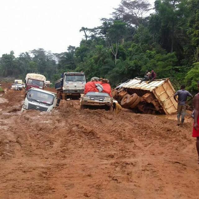
All settled, our roster of 13 loaded up. 3 in front – the County Education Officer (CEO) and I sharing shotgun. 7 in the back-seats, 4 adults and 3 children. 3 bringing up the rear in the flatteringly titled “VIP” trunk. Our mascot, the Goat, was tied atop the roof with our cargo. The engine turned over after some encouragement, and we were off to Zwedru.
The family dynamic unfolded soon thereafter. Up front, I mediated between the bickering couple Sammy and the CEO. In the back, the children rocked to sleep on their parents. Dan was working to hold his wedge next to the door, realizing bump by bump that his earlier reluctance was wisdom. Everything seemed to be going in the right direction, however chaotic the cabin conversations may have been. Before getting too uncomfortable, the car began to offer myriad chances to stretch our legs at every hill. One-time Sammy failed to mention his failing fuel pump, so we scurried on up the hills by foot as he inched his car by lead-foot up the hill. We journeyed to the midpoint in this fashion – and upon arrival there waited for two hours as he haggled around town for a cheap replacement. Off we went, again.
The sun fell in our dust as we picked up northward momentum. Town after village after town could be spotted from inside the dugout. Our stops were not excessive – only two. One in a gold mining town where 1970s country music echoed like a call-to-prayer. The other, a rite of passage here, was for a prospective bush-meat vendor. Sammy and the CEO came back sharing frustrations on the rising price of groundhog. They grew to thrive off of each other, and this was just the beginning of their voyage to Monrovia. Luckily, we only signed up for Zwedru. And we got there – 13 hours later.
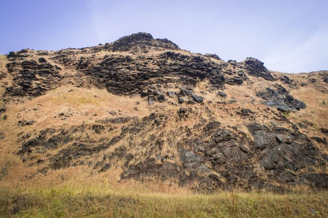
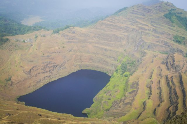
With one more day of travel, this time by way of the two-wheeler motorbike, we reached Yekepa. This town is steeped in iron ore mining history (not to mention, steep) and the base for hiking Mount Nimba, the tallest mountain in Liberia at ~1400m above sea level. Prior to Liberia's decimating civil war in the 1990s, the Liberia-American-Swedish Mining Company (LAMCO) built a 360km railroad from the town to the coast to ship the crude ore. Their open pit mining took advantage of the easily fractured rock, and in the 30-odd years of extraction they inverted one of the mountains into a deep, ridged lake.
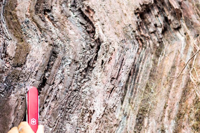
When the war prevented outgoing shipments from the port of Buchanan, LAMCO ceased operations. The drastic relief in the land is not the only mark the company left. The town of Yekepa was developed by a Swedish planner as evidenced by its rowed houses and public park veiled with Christmas lights. In 2007, ArcelorMital, the world's largest steel producer, reopened the mining site. The hematite schist deposit is extremely rich with iron – some 62% by mass and has an estimated bulk of 54 million tons, which they plan to export over 25-odd years.
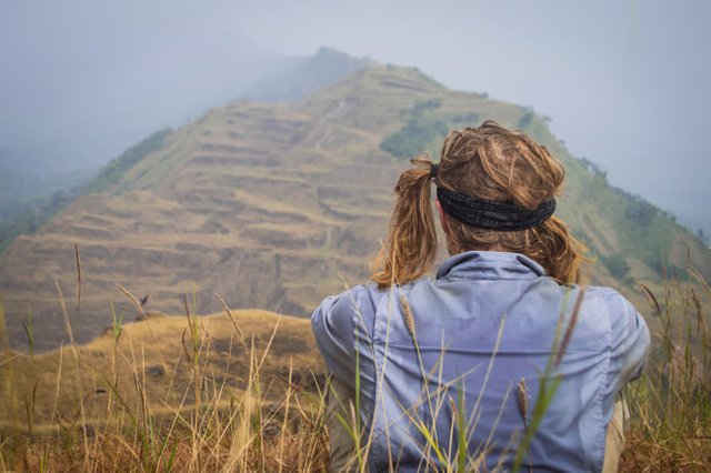
Our crew of 9 volunteers set to the mountain with a different end-goal – to summit the roof of Liberia. The single thing we knew about the hike was that we had to go up. Sparse information kept us guessing. “Where is the top? That side looks taller,” and “Who's down to try this shortcut?” We found ourselves coiling up the terraced mountain, kinking our path for craggy passages in the overgrown cliffs. Our accordion of paces added an element of tracking to the hike; trampled grasses and shouts kept us strung together. The last leg of the ascent was up a horribly steep gravel-path of our choosing.
around and saw another taller reach nearby.
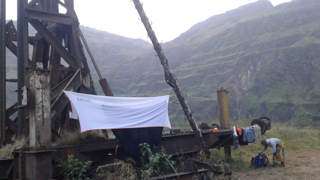
Getting up was simple enough: lean forward, stay low, and keep on. We reached a local high point marked by a concrete post – let's call it the peak. High-fives all around. Atop the peak, we saw into the lands of Guinea, Ivory Coast, and Liberia in one fell swivel. With some cloud cover... at least a full moon was on the rise. Getting down offered little room for error, and to minimize any injury we figured to commence in the fallen position. Sitting with our feet under us and arms spread like paddles stabilizing a row-boat, we began our controlled slide. Unfortunately, we did suffer one casualty. Likely the most cherished member of our trip, the distal joint of the Adventure Strap on my left Croc was fractured beyond recognition. The loss was tragic, but the winnowing daylight prevented mourning. We based at Blue Lake.
My friend from site warned that the lake's beauty was only that. A thing for looking. He claimed one could not swim there, and that if one threw towards it a rock, the rock would bounce away. He held back a laugh of pity when I mentioned our plan to try and submerge there. When we first arrived to the site we stopped the edge of a brief plateau. Tip-toe peering over, we saw Blue Lake, wrapped on all sides by cliffs. Loose pebbles tempted a toss– and sure enough we saw no ripple in the still water. Perhaps this was the hand-me-down tale's source. We further investigated Blue Lake base level when we set our camp there. This time – we busted the myth by soaking our strained muscles in the fabled waters and roasting char-dogs till the coals blew gray.
Brilliant writing, @jhimmel! I had to stop to laugh after every sentence, from one-time-Sammy to the County Education Officer!
I appreciate the comical take you added to what seems to be a bizarrely long trip just to get to the base of the mountain. I also appreciate the hematite-schist photo, as a retired geologist!
But give me more numbers! How many hours of hiking? What's your elevation gain? What's the temperature at the peak?
It happens to the best of us!
Wow, this Blue Lake scenery is so awesome. Great post once again, @jhimmel.
Congratulations @jhimmel! You received a personal award!
You can view your badges on your Steem Board and compare to others on the Steem Ranking
Vote for @Steemitboard as a witness to get one more award and increased upvotes!