Sulfur Dioxide Spreads from Kilauea to Micronesia’s Ancient Megalithic City
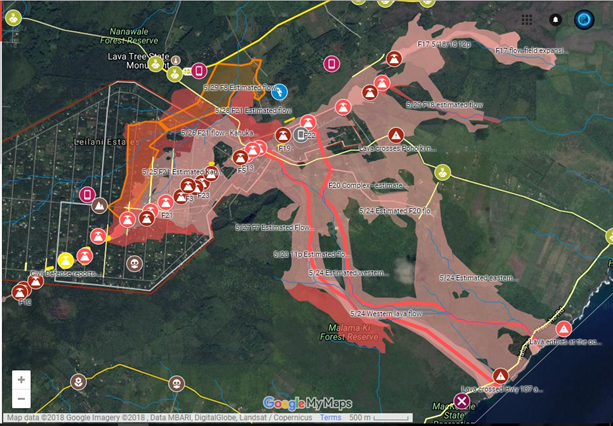
I’ve included the links to the Kilauea Eruption interactive map, so you can keep up with where the fissures are, and where the rivers of lava flowing into the ocean. These rivers are actually flowing as fast as river water is, it’s amazing the change in the composition of the lava the magma wherever it’s extruding from. And a couple more breakthrough points that shall be added to number 25 and 26 on this list here.
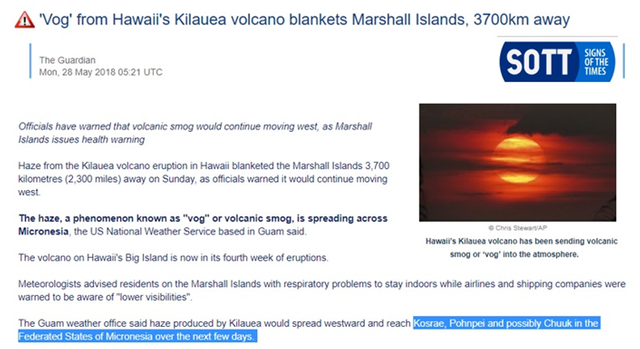
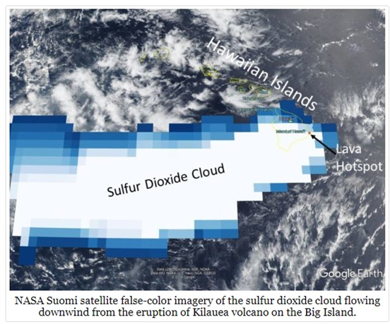
The reason I bring that up is because it’s a never-ending eruption at the moment and is now responsible for health alerts clear over in Micronesia. That’s approximately 3,000 miles west of the islands.
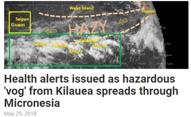
They’re calling it a VOG or volcanic smog, residents on the Marshall Islands are being hit first they’re warned to stay indoors with lower visibility for shipping. Then all the way over to Guam, Kosrae, Pohnpei, and Truck. This is all in Federated States of Micronesia, it’s a US Protectorate, bBut we’re looking at least at 3,000 miles west.
Yesterday’s video talked about the sulfur dioxide cloud. I also left interactive links below to the NASA site for that with the Swami satellite.
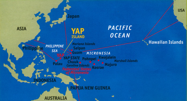
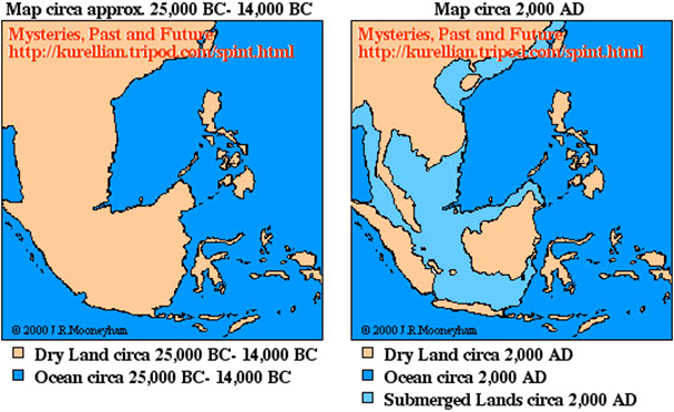
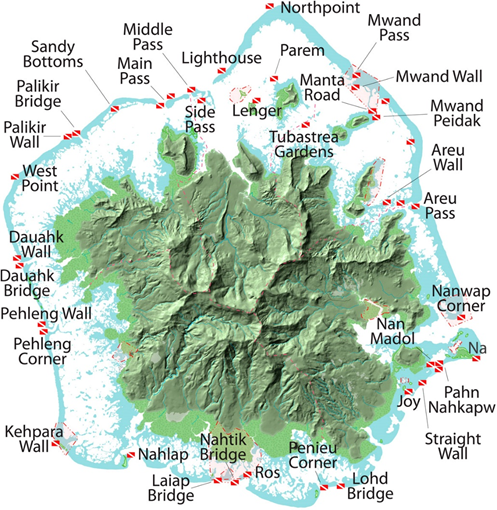
Taking a look at the map here, scuba diving fans you absolutely know where this is, Truck Lagoon has some of the best shipwreck diving from World War two anywhere on the planet. This was a major battle area between US and Japanese forces. Yap is where they have the giant stone money, Palau that’s the freshwater jellyfish area with some of the best visibility on the planet, drift diving, this is the absolute gem on the planet still to go scuba diving.
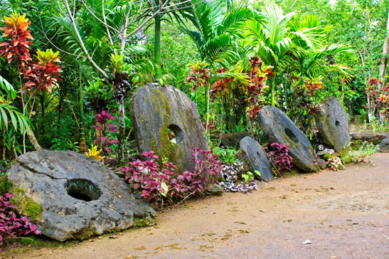
Yap has these giant stones circle money that was rolled from family to family. This was utilized absolutely as a medium of exchange in their island kingdom.
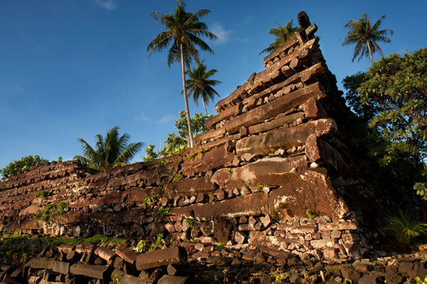
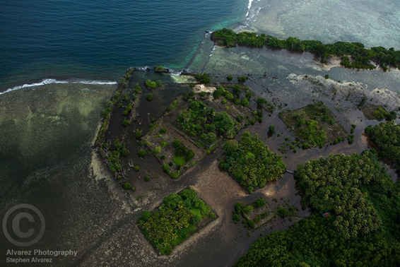
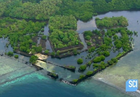
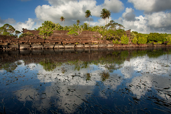
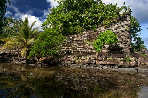
Classic historians give them no credit for being advanced in any way shape or form, just a bunch of Islanders living in bamboo and coconut shacks. Then there’s Nan Madol. This goes right into everything with his cycles of the Grand Solar Minimum, the cycles of our society and the cycles of our history. I want you to take a good look at this, this was built with megalithic stone blocks on a foundation.
Now supposedly with the classic historians, they say that well this was built in 1100 to 1200 AD, approximately 800 years ago.
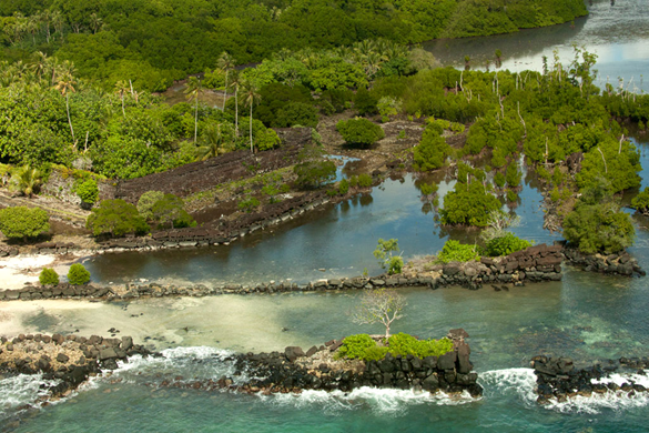
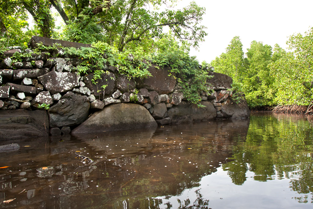
When we just look at the weathering of the base stones themselves, these megalithic blocks. Look at the weathering on that, and you have to think 800 years ago, they would have not built right here because it’s too close to the sea.
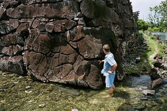
Wide out here so you can see the approximate height of the walls, these basaltic pillars, some of those are 70 tons, 30 feet long. How would they even be able to move such objects around the island, and why would they put it so far out and utilize so many resources to put this thing together?
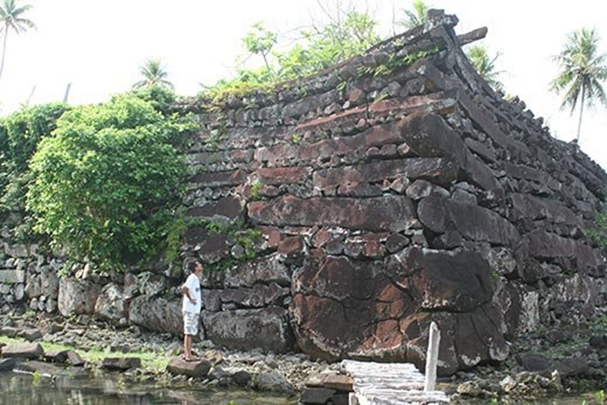
When you look at the very base of it, those stones are very different than what the walls are created from.
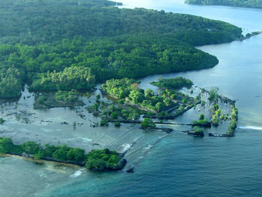
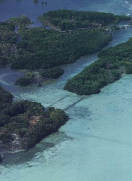
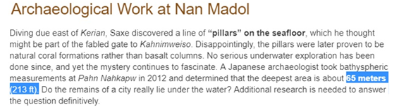
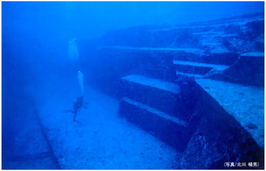
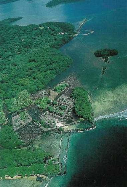
From aerial views, you can also see that these atolls were interconnected as well. If sea levels were approximately the same as today, they were sure not building this, we have to look back in previous times. Bringing you back to scuba diving and snorkeling, you could take tours out to this place, although the cultural ministry is really limiting where you can go and take photos because they’re starting to put two and two together, that a lot of researchers are going out there trying to look at these megalithic stones. What they are finding is in some of the deepest areas of the sunken city are 200 ton boulders 213 feet underwater with the stone foundations.
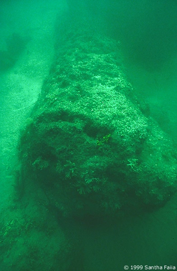
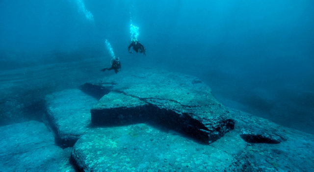
These are some of the pillars that are only in about 30 feet of water,
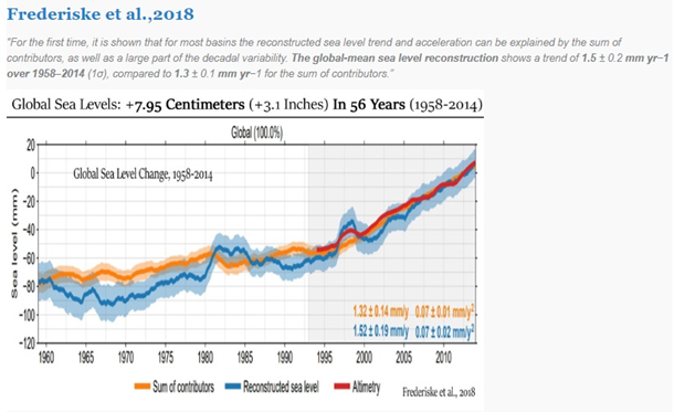
If we’re going to believe the classical historians, we have to take a look at sea level back then at 1180 AD, right in the middle of the chart were it says global sea level. You can see from that point forward, sea levels have dropped especially through the Little Ice Age maunder minimum because the glaciers were growing so there was less water, more of it was locked up in glacial ice more of it was up in the poles.
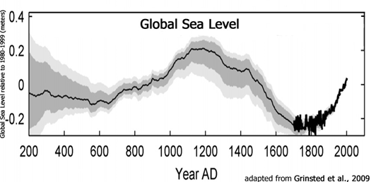
Even if we look at today what the IPCC says, global sea level rise since 1960 has only been three inches in 60 years. If we do the math and we take it out a hundred years, times ten, what’s that thirty inches, just under three feet. That is not going to inundate those megalithic stone blocks.
Another aerial view here for you, can really see the complexity of this, and how it rises.
I’m talking about the area that was 200 feet underwater, we have to go to the far right, where it says reef you see that circular enclosure there, that’s the area that’s down deeper. They think it’s an amphitheater of some sort, but again you’re forbidden to dive on this exact spot.
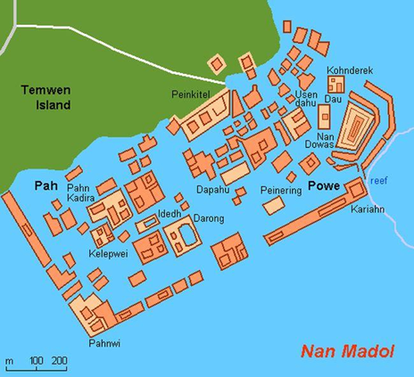
Don’t know why other areas right at coastal, you’re allowed to dive on you’re a lot of snorkel. But when it gets out to the periphery of the foundations of the enclosure itself you’re forbidden from going out there. They cited as currents and deep water. I don’t know you can snorkel right there and you can exactly see where some of these basaltic rocks are.
Let’s take a look at the different types of foundational stones compared to what the wall building stones are. Those are in the hundred ton range for these boulders, megalithic blocks on the bottom foundation there. Even when you’re looking at what these longer pieces are, they call them the pillars, those things are 30 feet long and in in the 50 to 60 tone range. We’re told that it’s a bunch of people living on an island using coconut shacks and they’re building something like this, does not add up at all.
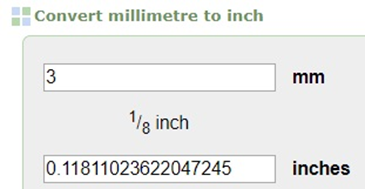
Even if we want to use the sea level change from 1900 to 2010, we’re talking about a hundred years of sea-level change. I’ll even take you ready to the middle I’m going to be the devil’s advocate I’m going to go with three millimeters per year.
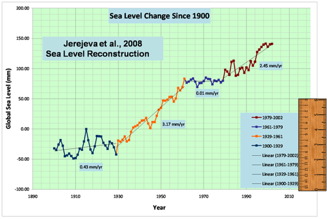
We match that out, that’s a tenth of an inch. So every ten years that’s going to be an inch.
We really have to do is start looking back in history and saying wait a second. This goes right back into the cycles that I’m always studying with this Grand Solar Minimum. If we’re going to be looking at foundational structures at that point, where they’re located currently at Nan Madol. We really need to go at least eight thousand years back into the past where sea levels would be sixty feet lower.
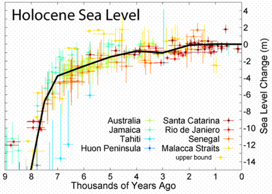

Traditional history tells us globally there was no evolution to this complexity of architecture, mathematics, and construction methods at that point 8000 years ago. We’re talking about hundred ton blocks, moving to the most remote part of the island. The only plausible explanation is that during the last ice age sea levels were far lower than they are today. You can see different continental formations, and we’re starting to find cities across the planet that are out in the continental shelves that are now flooded. This makes the most sense that there was a prior culture, we keep reading about this and all the traditions.
When we come to places like Yonaguni, which is the exact same kind of depth, where the far edges of Nan Madol’s foundational structures are. If you take 150 feet of water away from here, Yonaguni is above water yet at the same time so is Nan Madol.
We’re supposed to believe that, this is all just natural. these angles that you’re seeing and these reverse reliefs here, this is all supposed to be just natural erosion at a hundred and thirty feet under the water.
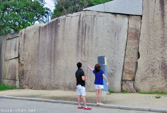
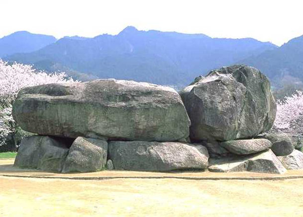
When we’re looking at Kyoto palace, I have been there myself, they’re using megalithic blocks that have no explanation of how they built this as well, there’s not just one of these, there are several strewn about in the foundational structure.
When we come up to Ishii Butai these megalithic stones, that you see here are at least 600 tons at the minimum.
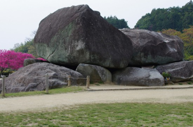
Different view for you here, so you can see approximately how large they are.
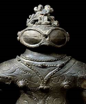
Stories from Japan, the Jomon people, had taught them the skill on how to levitate and move such large stones.
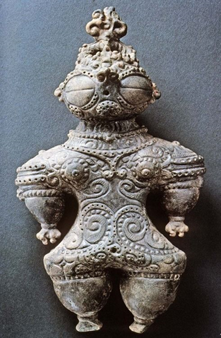
We start to match up in history the same legends and stories about how people pass down this vibrational technology.
Why are they so focused on the Beidou Qixing, they call it the Big Dipper cult? It’s pervasive through China, Japan, and all of Asia. The center of the culture was around this, all because they were following the cycles. this ancient history here.

I’m going to bring you right back to Nan Madol, it’s far on the east right in that break in the reef super remote. Why would somebody build such a remote structure out there?
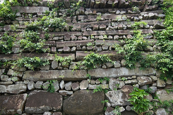
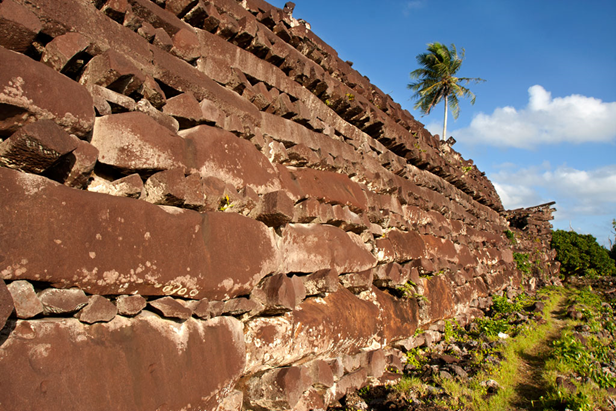
I zoomed in a little bit here, so you can really see the size of the stones that were used to construct at least their outer walls here.
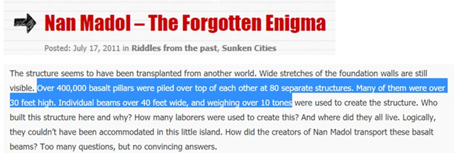
We’re looking at four hundred thousand basalt pillars to construct this area.
These individual beams or the pillars that I’m talking about with the length on those things, 30 feet we’re looking at ten tons minimum. We need modern cranes to approach to make something like this move into the correct position.
Take a look at how high the walls were how much manpower would this take to construct. With modern history we’re just told hey they’re living in coconut huts.

I’ll run you through a few more images here you can take a look at why they would even put such foundations in water.
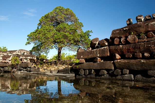
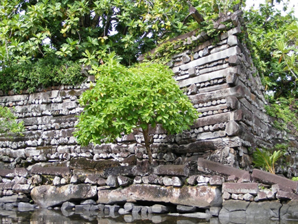
The walls are intricate and these stones are massive.
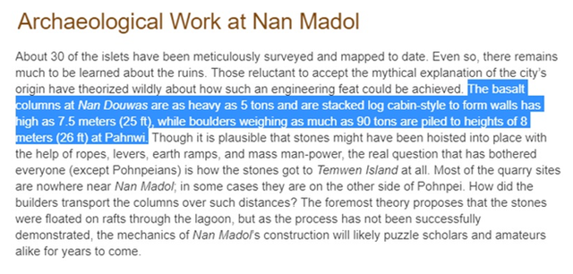
Some more archaeological work being done at Nan Madol, they put it as log cabin style construction five tons. But we find the same exact thing in Indonesia.
Twenty-five-foot-tall walls
Those boulders at the bottom, at the base are 90 tons. The periphery stones you’re looking at are 90 ton stones. You can see the bottom construction and the weight of the stones is far different from the top. It’s almost like two prior cultures and civilizations have been involved in building this structure.
It appears that there are roads heading off into the deepest section, but why would they build roads if it was going into the water already? There’s been no earthquake damage that made this reef sink so quickly? There are a lot of unanswered questions.
I’m going to bring you back to the Power of Volcanoes part one, this is a must watch if you were going to understand the Late Antique Little Ice Age, and how the sulfur dioxide pervaded the planet, weaken the immune systems of people around at the time. This is what was the cause of some of the reduction of population, was breathing this gas day after day, year after year after multiple volcanoes across the planet were in continuous eruption mode. Here we go again, the first one is Kilauea, two more to go and we’re going to repeat a Late Antique Little Ice Age sulfur dioxide event.
Wrapping ancient history and the cosmic cycles into what’s going on now globally because it is definitely all interconnected.
Links to all of the articles in the video
ADAPT 2030 Mini Ice Age 2015–2035 Series on YouTube
https://www.youtube.com/user/MyanmarLiving
Sulfur Dioxide Cloud Drifting from Kilauea
SO2 Map from From NASA Interactive https://worldview.earthdata.nasa.gov/?p=geographic&l=VIIRS_SNPP_CorrectedReflectance_TrueColor,MODIS_Aqua_CorrectedReflectance_TrueColor(hidden),MODIS_Terra_CorrectedReflectance_TrueColor,OMPS_SO2_Planetary_Boundary_Layer,OMPS_SO2_Upper_Troposphere_and_Stratosphere,OMPS_SO2_Middle_Troposphere,OMPS_SO2_Lower_Troposphere,Reference_Labels(hidden),Reference_Features(hidden),Coastlines&t=2018-05-21-T00%3A00%3A00Z&z=3&v=-177.5473943280347,9.966492052023124,-145.8364568280347,28.212585802023124
NASA satellite reveals extensive Hawaii SO2 cloud http://www.drroyspencer.com/2018/05/nasa-satellite-reveals-extensive-hawaii-so2-cloud/
CO2 Man vs Volcano https://agupubs.onlinelibrary.wiley.com/doi/epdf/10.1029/2011EO240001
Volcanic Ash Historical from 1800 https://spaceweatherarchive.files.wordpress.com/2018/05/volcanic-aod-post-pinatubo-gmac-poster-2018-keen-1.pdf
‘Vog’ from Hawaii’s Kilauea volcano blankets Marshall Islands, 3700km away https://www.sott.net/article/386837-Vog-from-Hawaiis-Kilauea-volcano-blankets-Marshall-Islands-3700km-away
Nan Madol https://subharanjangupta.wordpress.com/2011/07/17/nan-madol-the-forgotten-enigma/
Nan Madol Ruins IMAGES http://www.pohnpei-adventure.com/nan-madol/
https://en.wikipedia.org/wiki/Nan_Madol
Hawaii Interactive Eruption Map https://www.google.com/maps/d/u/0/viewer?urp=https%3A%2F%2Fwww.facebook.com%2F&mid=1CvBhH9wEeztBrqYbsGDi4YjU1k1QH5AL&ll=19.46358792985176%2C-154.88495347724609&z=14

Oh I love stories like this about old sites and sunken cities. What i would always look for, as you did are old tales and fairy tales, those always contain a bit of the truth.