Everyday Geography #9 Different types of river deltas
There are over 261 030 kilometers or 162 196 miles of major rivers, which is enough sail around the earth 41 times and would bring you already 2/3 of the way to the moon! Assuming you have a space'ship'. All these kilometers of river have to flow back to the sea or another body of stagnant water eventually, and when it does it can form a delta thanks to the sediments transported by the river. The conditions in which the river deposits varies strongly and so do the types of delta.
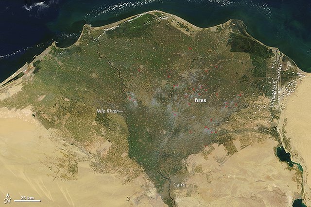
Satellite image from the Nile delta marking small, probably agricultural fires in 2014. Retrieved from the MODIS datset by NASA
It has been a while since I wrote an "Everyday Geography" where I write about common geographical phenomenon that only stand out when you know about them. So it was about time I continued writing those. After this article you will never look river mouths the same.
Dynamics of deltas
Deltas are in a continuous dynamic balance between deposition and erosion that can be disturbed. This causes them to be subject to 3 types of movements:
- Progradation: Lateral expansion of the delta sea inward by increased sediment load relative to the wave and tidal energy
- Aggradation: Vertical expansion of deltas caused by overflowing rivers, over the delta, depositing sediments vertically
- Transgression: Lateral decrease of deltas due to increased erosion or decreased sediment load.
It is important to note that the main driver in the morphological structure of deltas is the balance between sediment deposition and erosion of that same sediment.
Factors conditioning deltas
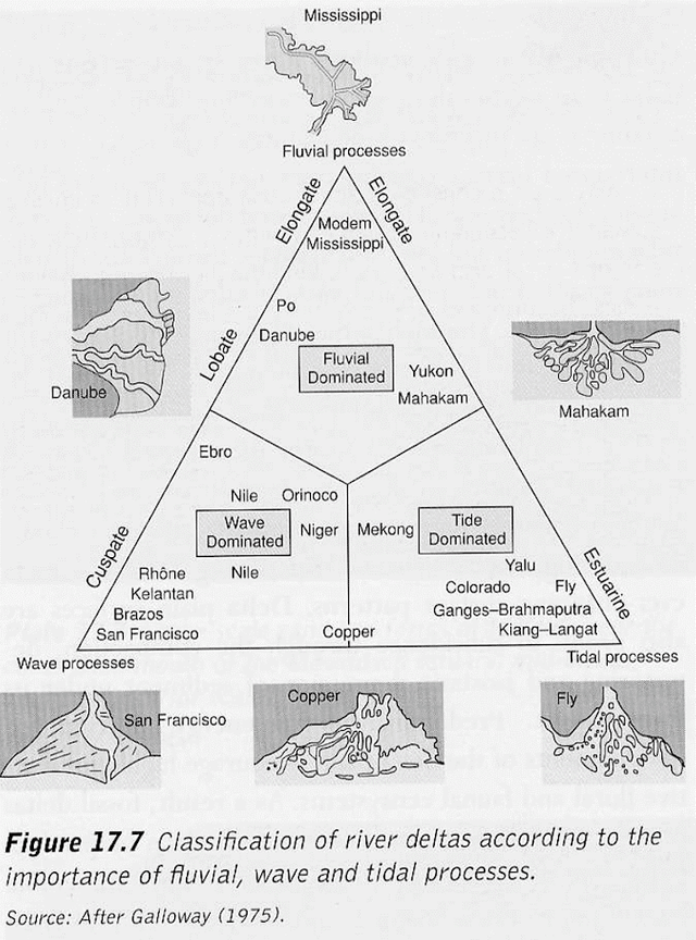
William E. Galloway (1975) wrote a great paper and framework on the description of morphological deltaic depositional systems. According to him both the sediment load of the river and the energy of the receiving water body determine the morphological structure of the delta. When looking at it like this three mayor conditions can be found.
- Dominated by fluvial processes
- Dominated by tidal processes
- Dominated by wave processes
Most often depositional systems are a mixture of different dominant processes and in the graph below a visual representation is made of these systems with examples.
Fluvial processes as dominant depositing actor
When fluvial processes dominate the deposition of sediment the 'typical' delta can be found. This can either occur when a large catchment area flows into the sea which is the case for the amazon river or when the receiving water body has too little energy to remove the deposited sediment.
This type of deltas for example, can be found often in smaller seas and lakes as they are rather isolated from larger oceans and the energy of waves is limited.
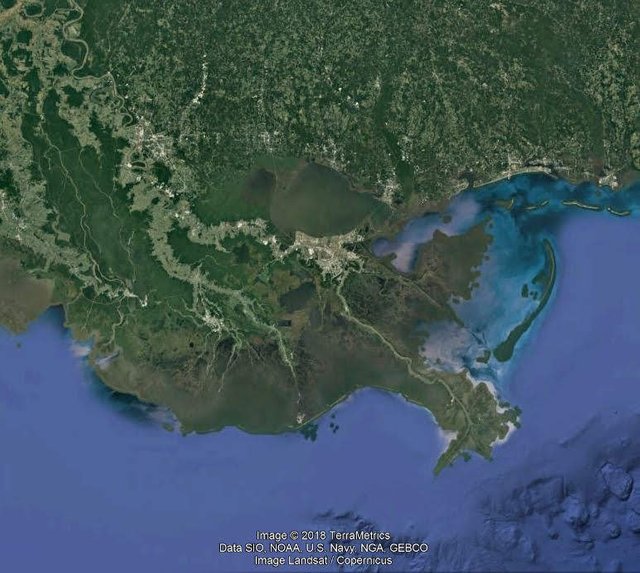
Satellite image of the Mississippi delta (USA). Heavy sediment fluxes cause progradation.
Cultivated river delta of the Po river (Italy)
Wave processes as dominant depositing actor
Waves can smooth the edges of a delta such as the Nile. The energy of the waves also commonly builds a coastal barrier which is nicely illustrated in the delta of the Ebro river (Spain). This barrier allows the formation of a coastal lagoon. Strong storms or extreme river discharges might cause breaks in the coastal barriers, but they are naturally closed again by longshore transportation.
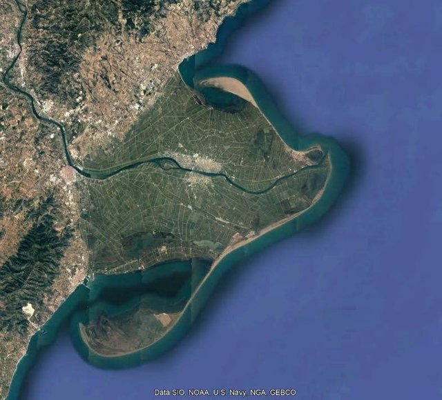
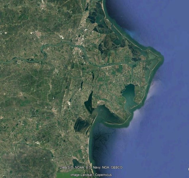
Delta of the Ebro (Spain) river with clearly visible coastal barriers. Fluvial processes still play an important role as the delta is strongly progradated.
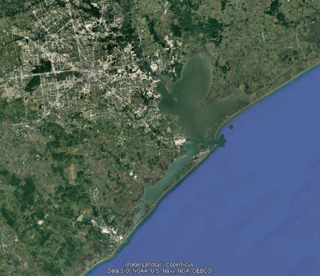
Delta of Brazos (USA). Again barriers and also the coastal lagoon are clearly visible.
.
.
Tidal processes as dominant depositing actor
Tides cause for strong water currents flowing in and out the river mouth. These strong forces leave a deep mark and these deltas often contain sand bars and ridges with a dendritic pattern. The mixing of salt sea water with the fresh river water cause for different ecological habitats on a small space, ranging from salt, brackish to sweet water. Also the periodic rise of the water cause for mud flats and salt marshes.
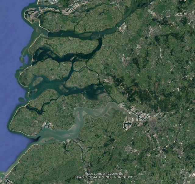
Estuary of the Scheldt (Belgium) where the tides cause the sea water to enter the estuary, causing strong currents and somewhat dendritic sand bars.
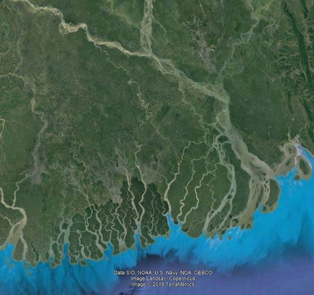
Estuary of the Ganges (Bangladesh) Strong tidal changes combined with a heavy sediment load cause for this pattern.
Conclusion
This is just a general classification of the different environments causing differences in delta morphology as many smaller differences causes the uniqueness of each delta. The types that were discussed are also conceptual types and in reality each delta is a combination of these, as visualized in the triangle. Next time you come across a river mouth, try to identify the processes at play!
Sources
Holden, J. (2012). An Introduction to Physical Geography and the Environment. Retrieved from https://books.google.com/books?id=6uuoBwAAQBAJ&pgis=1
Galloway, W. E. (1975). Process framework for describing the morphological and stratigraphic evolution of deltaic depositional systems. Deltas: Models for Exploration, (September), 87–98.
Esri, Bartholemew and Times Books, Digital Chart of the World (DCW), U.S. National Geospatial-Intelligence Agency, NASA Earth Observatory, EROS Data Center of the U.S. Geological Survey, NASA Visible Earth, Rand McNally and Company, NASA JSC Digital Image Collection, SouthWestern Bell WorldRoom, U.S. Geological Society (Landsat) (https://www.arcgis.com/home/item.html?id=44e8358cf83a4b43bc863646cd695945)
https://spaceplace.nasa.gov/moon-distance/en/
https://www.thoughtco.com/geography-of-river-deltas-1435824
http://www.coastalwiki.org/wiki/Wave-dominated_river_deltas
Everyday Geography: previous posts
Everyday Geography #8 Different types of fog and mist
Everyday Geography #7 Tracing back common city patterns: radial and circular city pattern
Everyday Geography #6 Tracing back common city patterns: Grid plan
Everyday Geography #5 Recognize your weather pattern
Everyday Geography #4 Why some dry soils crack
Everyday Geography #3 What makes salt tolerating vegetation special
Everyday Geography #2 Meandering, braided and straight rivers
I looked up the Hudson (my backyard) and read that it does not have a plain at its mouth because of its "youth". Where would the Hudson fit in your triangle?Wave process (San Francisco)? Found this essay easy to understand--I'm not a geologist or scientist so that's good :)
Thanks that is what I aim for :)
The Hudson and its mouth are strongly shaped by the geology there, but on the near coasts, barriers and coastal lagoons are clearly visible. So I also would place it in the category of wave dominated. Tidal forces are also present there, but I don't think it shaped the morphology.
Thank you! I'll have to catch up on the previous posts you list...
Do inland deltas, like the Okavango delta, fall into this broad classification as well?
In that case it would be dominated by fluvial processes and move via aggradation?
Or do they form they have their own classification?
I believe you could follow the same thought pattern, but there are some major differences. Mainly that there are no strong wave or tidal forces eroding the deposited sediments. So indeed fluvial deposits would dominate and the sedimentation should lead to aggradation.
You've just put a life to my interest in Geography with this post. Gotta check your previous Geography posts as well. Thank you for giving us this.
I am @teekingtv and I write STEM.
oh how flattering! 😊
Oh no! 😂
Really cool post with awesome google earth derived images/maps. Sorry I missed this. I'm upvoting your comment instead since it is older than one week. Cool work and informative.