Around the Cabo de la NAO routes along the coast
Around the Cape of the NAO
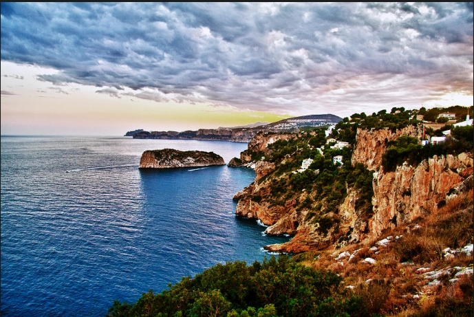
The Cabo de la Nao and its surroundings make up one of the most rugged enclaves of the Alicante coast.
The proposed route allows, in little more than 30 km, to visit the most interesting corners of these coasts, in which they happen Cabo, gulfs and bays.
As well as the populations that have the greatest cultural and tourist offer.
The Marina Alta
Tourist centre of First order in the north of the Littoral Alicante, Denia is also the capital of the region known as Marina Alta.
Its great commercial and cultural activity.
Increased by the presence of a good number of visitors, it has been reinforced by the growing importance of its port.
From it you reach the island of Ibiza, so that the transfer of goods and tourists is elevated.
For lovers of bullfighting, Denia offers the singular celebration of the bous to the sea.
Peculiar bullfight in which the participants are thrown into the water.
It is advisable to walk along its main street, that of the Marquis de Campo, as well as the vicinity of the port.
In which the traditional cleaning of the fishing nets is still carried out when the boats unload in the Lonja.
The main monument of the city is the castle, located in the highest part of it.
On a promontory, in whose interior the collections of the Historical and archaeological museum are exposed.
In the restaurants distributed by its streets you can taste dishes like the suc roig or the rice with band, as well as a multitude of fish, that arrive to this population through the port.
Separate mention deserve the famous raisins of Muscat grape.
Above the population, inland, stands the massif that configures the natural park of the Montgó.
One of the most important natural areas of the province of Alicante.
The massif rises to a height close to 750 m at a low distance from the sea.
and consequently, it gives rise to some terrains of unique ecological characteristics.
Penetrating it from Denia allows to contemplate beautiful rural and agricultural places where the rainfed crops occupy much of the territory.
The rest the landscape is dominated by limestone, which rises in an almost continuous cliff or rocky cut of more than 100 m of height.
It is precisely the calcareous nature of the terrain that has led to the emergence of some of the most interesting places in the natural park.
It is the caves and chasms, which include the Cova ampla, the L´Aigua or the Barranc del MiG.
Some of which have made important archaeological finds that trace human history in these areas to the Upper Palaeolithic.
The massif as a whole, as well as the flat area leading to the Cabo de San Antonio.
They are splendid places to contemplate the flora and fauna typical of the Alicante coastline.
In few places is also represented as in this.
There are more than 600 plant species listed in the area, many of which are endemic.
Abundant are also the fauna species that occupy the park.
Including the Wildcat, the Peregrine falcon, the wild boar or the Royal Owl.
The scenery in which all these species can be observed is complemented by an ideal rock coast for scuba divers.
It develops numerous forms of algae.
While in the loose-not excessively extended funds-meadows of Posidonia and Cymodocea appear.
That greatly increase the ecological diversity of the environment.
The boat ride with a glazed hull by the cliffs allows you to have a different view of the same environment.
An opposite image and a great force.
You can also enter the Sierra de Montgó by Xábia.
In the urban area of this town stands the Church of San Bartolomé.
Erected in the 16th century and whose interior served as a refuge for the population during frequent attacks by Corsairs and pirates who were besieging these shores.
On both sides of the main door of the temple you can see still two openings that allowed defending from inside the siege of the assailants.
The population, to which the tourist promoters have renamed the "Dawn of Spain", is the most oriental Spanish city.
It is endowed with all the services that the summer tourism demands.
The limestone that composes a large part of the geological substrate of the Marina Alta appears in the streets of this splendidly carved population.
lintels, sills and bows, show the mastery of the local carvers.
Artisans of whom it is still possible to obtain some samples of their work in the workshops that last.
Near the city are located areas of special landscape and ecological interest, such as the rocky coastline of the Marina Alta and Los Cabos de San Martín and La Nao.
Xábia welcomes in its municipal term some of the most beautiful and best preserved beaches of the coast.
Its protection has contributed to the hardness of the terrain, which overlooks the sea in the form of high cut and coastal cliffs in which it is not easy to urbanize.
Some coves, however, open between so much vertical rock and are covered by gravels or boulders; They are small beaches and difficult to access.
From Xábia, the route is internalized by an area that in its first sections corresponds to the flat portion of the territory that surrounds the inlet of the river Gorgos.
Beyond the Arenal Beach a particularly rugged area is opened.
Accessed by the Portixol road or on foot.
The first cove to appear is the white one.
Which is reached on foot by a road of about 400 m, which connects to the nearest parking lot.
The beauty of this cove lies in addition to its clean and transparent waters.
In the dense wooded masses that cover the upper ground.
The cliffs, in which abound the holes and the cavities.
It offers excellent possibilities of refuge to many birds.
So the observation of species in this area is a very gratifying activity.
On the other side of a powerful rocky escarpment, is located another Virgin Cove.
The sardine, also called Cabo de San Martín.
of similar characteristics, but less visited than the previous one.
To be a little farther away from the population.
The buses that depart from Xabia stay about 400 m from the first and one kilometer from the second.
South of the Cape of San Martín opens the most abrupt area of the coast.
The coastal cliffs or "morras" rise more than 100 m in vertical in Some areas.
The beaches are small and scarce although, yes, very beautiful.
The beach of the Portitxol, with the island of the Portixol opposite.
It is one of the most pleasant of all this stretch of coastline.
The buildings in the vicinity are small and not too aggressive.
The typical thicket of the Mediterranean coast reaches the very edge of the water on the rocky and rugged coastline.
It has an approximate length of about 600 m, which are covered with thick sand and some pebbles.
At its southern end penetrates into the sea the Black Cape.
The Cape of the NAO is the most oriental of all.
The imposing limestone rock rises more than 120 m.
To the lighthouse, which is at its end.
You can reach by car by the road that departs from Xabia.
In the surroundings of the Cape are located beautiful beaches and coves like the Amboo, presided by the homonymous tower.
A Coast Guard watchtower.
This beach is one of the favourites of nudism practitioners.
Although in all this rugged coastline are not rare the enclaves in which it is practiced.
On the other side of the tower, the one that is considered the most attractive beach of all this coastline is opened.
It is the famous beach of the Granadella.
At the bottom of a small cove between two important rocky escarpments.
Its more than 200 m in length are covered with thick golden sand and some pebbles, typical materials of this coast.
An urbanization, which receives the same name as the beach, has settled in the surroundings.
But it seems that its impact is minimal.
The services offered in this cove, however, are of the most varied.
It has been endowed with a certain tourist infrastructure and annually is awarded the Blue flag.
In front of it is the island of the discoverer.
Formed by a solid calcareous rock that shows important signs of the erosive activity of water on the rock.
A few kilometres south of Cabo de la Nao, under imposing cliffs that make up what is called Les Morres de Benitachell.
Small coves are opened and difficult to reach.
They stand out among them the cove of the pots.
Very close to the Cumbre del Sol urbanization and Cala Llebeig, more Southern.
And whose access is signposted with red marks on the path that goes down to it and extends about 2 km.
Access to the first is relatively easy from the town of Benitachell, which is about 4 km away.
It is habitual in her the practice of nudism.
On the rocky escarpments that protect it appears a good representation of the littoral Maquia.
It is possible to discover the presence of some birds typical of the coastal cliffs.
Fishing is located on the cliffs.
Small platforms to which the fishermen were unhooked for their work to cane.
Since the immediate waters to the cliffs are especially rich in fish of the so-called rock species.
In the area there are some couples of peregrine falcons.