Slow Moving Hurricane Dorian Stirs Memories Of Hurricane Matthew
Slow Moving Hurricane Dorian Stirs Memories Of Hurricane Matthew
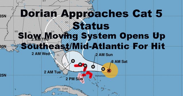
Good morning everyone. We continue to watch Hurricane Dorian evolve and frustrate many with its slow movement. The slower it goes, the more everything changes due to the movement of all of the steering features elsewhere throughout the Country and the Atlantic. This opens up more parts of Southeast, while sparing others from last minute surprises.
Up here, our Labor Day weekend is underway and continues to hold, but our medium range remains uncertain as we watch and see what Dorian does.
SATELLITE

More Sun than clouds will continue today, with a steady northerly flow, comfortable dew points, and highs in the low 80's.
A return flow will begin tomorrow as high pressure begins to slip to our east, knocking down the temps a notch or two, but nothing significant. Expect highs in the upper 70's to near 80, and a very slight chance of a shower.
Labor Day on Monday is looking ok and I still wouldn't cancel outdoor plans even though it won't be much of a beach day. We are still looking at more clouds than sun, maybe not much sun at all, with the slight chance of an afternoon shower or rumble. Highs Monday in the upper 70's to near 80.

I'm holding off on late week due to Dorian while we wait and see what he does, but we warm up pretty good after Monday. Look for low to mid 80's and humidity to return on Tuesday, then we watch for a cold front on Wednesday.
Hopefully that approaching cold front will be enough to suppress everything well to our south late week; but at minimum, it'll give us a very warm to hot day on Wednesday, with the chance of a heavy storm in the afternoon/eve. We could see upper 80's to near 90 on Wednesday.

Dorian continues to give the weather community and the coastal community fits as it has slowed down to a point in which its final destiny is changing and more complicated. As Dorian comes to a near halt in the Bahamas, the rest of the region's weather features will continue moving.
High pressure sliding further and further away from the Northeast, plus a cold front approaching mid week, opens up the steering currents to turn Dorian on a more northerly track as it nears Florida. This is very similar to what happened to Hurricane Matthew. Things were looking very dire for south Florida, then suddenly it all came to a halt and paralleled the coast.
The coastal communities of Florida cannot be relieved yet. It can dip just inland as it takes this turn and do a lot of destruction, or come close enough in which the precipitation and storm surge can do the same, even without making an official landfall. It's also time for coastal communities of GA, SC, and NC to take notice and begin their prep work by going over your supplies and plans.
What it means for us up here is not important right now. We will focus on the short range and who will see the worst effects of Hurricane Dorian down south first.

Please note that with regards to any tropical storms or hurricanes, should a storm be threatening, please consult your local National Weather Service office or your local government officials about what action you should be taking to protect life and property.
Posted from my blog with SteemPress : https://www.nycweathernow.com/slow-moving-hurricane-dorian-stirs-memories-of-hurricane-matthew/