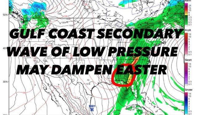
GLOOMY BLOCK AHEAD AS GULF WAVE MAY DAMPEN EASTER TOO
DOWNLOAD MY NEW FREE JOESTRADAMUS WEATHER APP FOR ALL DEVICES
(Unsupported https://www.facebook.com/plugins/post.php?href=https%3A%2F%2Fwww.facebook.com%2Fmeteorologistjoecioffi%2Fposts%2F10161417866420387&width=500)
GLOOMY BLOCK AHEAD AS GULF WAVE MAY DAMPEN EASTER TOO
Good morning everyone. Enjoy the sun today in the NYC area, because this may be the last time you see it in its entirety for 6-7 days if we don't squeeze out some tomorrow. Meanwhile, we watch and see if our late week/early weekend system gets hung up due to a secondary wave of low pressure, dampening Easter Sunday as well. Not much great news going on other than the fact our temps aren't bad in either direction.

The wind has settled down a little bit from last night, but we'll still have a breezy day with 25-30mph gusts at times, especially until late afternoon. Full sunshine and a westerly flow will keep us seasonable and dry though, highs in the low to mid 60's after a chilly morning.
Later today, clouds will arrive as a weak area of energy approaches from the west. That'll throw in the slight chance of some light rain overnight and early tomorrow morning.
We'll have one more slight chance of sunshine if the window is big enough, with weak energy departing, and our next larger system approaching. If we do see any sunshine tomorrow, expect decreasing clouds late morning, then increasing clouds again as the day goes on. Highs a seasonable low 60's.

Expect more clouds than sun on Thursday. We'll have the slight chance of some showers at any point during the day as that large system marching east, sticks out a long jab in the form of a stretched out warm front. We'll be on the cool side of things with a raw mid to upper 50's.
That warm front will make it past the area overnight Thursday/some time Friday morning and things will get soupy. Look for more tropical style showers and a few rumbles of thunder possible Friday afternoon; highs in the mid to upper 60's. As far as severe weather prospects, we'll take it day by day and see what the overall energy/setup looks like.

For your weekend, that cold front clears the area slowly on Saturday, with more showers and thundershowers possible till midday/early afternoon. A repeat of mid to upper 60's is possible, but then things possibly get complicated for Easter Sunday.

We could see a window of sunshine on Easter as Saturday's cold front may clear things out long enough before clouds move back in. I still believe 60's are a decent bet for Sunday, but sunshine is in question and we could be back into the gloom and light rain at some point during the day.
Stay tuned!

Please note that with regards to any tropical storms or hurricanes, should a storm be threatening, please consult your local National Weather Service office or your local government officials about what action you should be taking to protect life and property.
Posted from my blog with SteemPress : https://www.nycweathernow.com/gloomy-block-ahead-as-gulf-wave-may-dampen-easter-too/