Beautiful Weekend Ahead Long Range Cool Prospects Bleak
Beautiful Weekend Ahead Long Range Cool Prospects Bleak
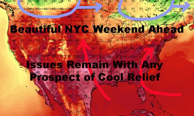
Good morning everyone. We had a nice light and wind show yesterday in parts of the area with our final cold front coming through. This will open up the area for a nice 4 day dry stretch, with varying amounts of warmth. Meanwhile in the long range, models are starting to fall in line with what I've been talking about the past couple of weeks; and that is the lack of a true cool "blast" and more average to above average temps down the road.
SATELLITE


To start the week, we could be looking at a warmer one on Monday, as favorable wind profiles could help boost us into the upper 80's to low 90's, then we should back off a bit if a front and some moisture begin to interact with the area.
As of now, I'm not going to call the ball on precipitation yet, but we could see some activity late Tuesday and maybe a few showers along the way during the week. Highs temps will be precip/sunshine-dependent, but we should be at or near average with low to mid 80's.
If we can clear everything out by next weekend, we could actually be looking at another very warm one compared to the 60's and 70's some of these wonky models were showing for mid-August. Regardless, I think at minimum we are near-average in the low 80's, but could go upper 80's to near 90 if conditions allow.

That brings us to some more long range talk, where models are starting to depict the issues that I've been talking about for a while. There is no true mechanism to bring very cool air into the area for a prolonged amount of time.
Yes, we could still see A cool day, but the core of these cool air masses are sliding through Canada west to east at a decent clip. Meanwhile, very warm to hot air continues to be pumped into the Midwest and Southeast. That makes it very hard for an unseasonably cool air invasion to happen, and any cool air that happens to dip in, will be expelled very fast.
We are on the downward slope of summer now, where average highs temps on paper continue to slowly subside, but we have a long way to go until fall and an early fall in August is unlikely.
Please note that with regards to any tropical storms or hurricanes, should a storm be threatening, please consult your local National Weather Service office or your local government officials about what action you should be taking to protect life and property.
Posted from my blog with SteemPress : https://www.nycweathernow.com/beautiful-weekend-ahead-long-range-cool-prospects-bleak/