What you didn't know you needed to know about the Belgian coast.
With its 65 km's (40 miles), the Belgian coast is not one of the most phenomenal features in the European landscape. But nonetheless there are very interesting events and phenomena that took place here. Let me give you some information that you didn't yet know you needed to know (until now).
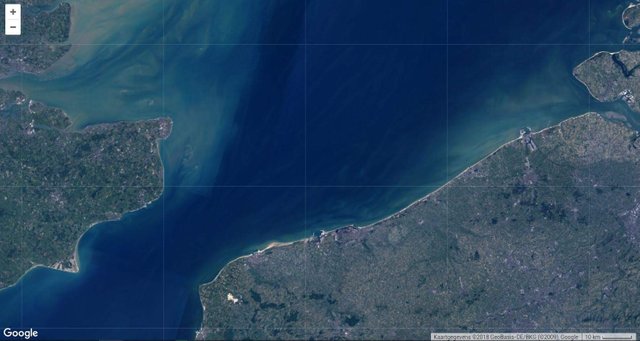
Satellite image from the Belgian coastal region. Exercise: Can you point out the United Kingdom, France and the Netherlands? Image from public data retrieved with the Google Earth Engine.
Our sandy coastline has never been static and 200 years ago you wouldn't even recognize it as being Belgian. It is only since the second half of the 19th century that humans began to shape the coastline.
How our coast was shaped
Before the Roman period, the Belgian coast was subjected to several transgression and regression cycles where the land periodically flooded and dried again.

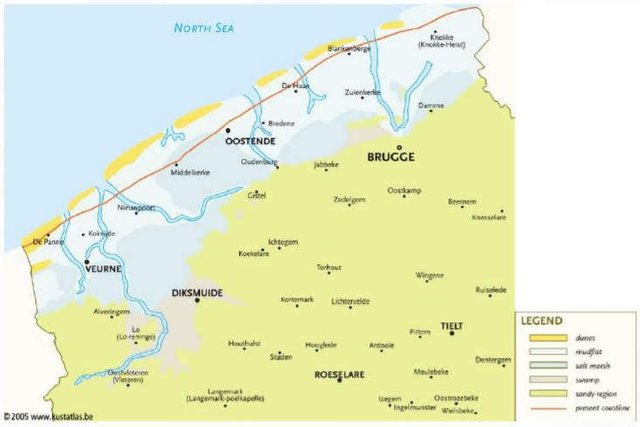
The different transgression cycle that shaped the coast. Duinkerkiaan 1 (200 BC -100 AD), Duinkerkiaan 2 (300-700 AD), Duinkerkiaan 3a (1000 AD) and Duinkerkiaan 3b (1100 AD) named after the city of Dunkirk (which is French territory now) Illustration from Marian & Frank, 2010.
For a long time the coast has been a system of salt marches and swamps, but after the Roman period sea levels began to drop and the area gradually freshened so salt marshes were gradually replaced by freshwater vegetation. For example Bruges, which was once called the Venice of the North, no longer had a connection to the sea after the 12th century.
Roman period
When Julius Caesar conquested northern Gail and entered the territory of Belgae (Hence the name Belgium) in 50 BC, the coastline must have looked something like this (Duinkerkiaan 1).
Schematic representation of the coastal region in the Roman period (Belpaeme et al. 2004)
Colonization of the polders
It was only at the end of the 19th century, when population growth and new technologies forced people on these lands, that this marshy, salt environment was colonized. completely new townships were designed and protection measures such as dykes, breakwaters, dune reinforcements and complex water systems were built to protect this new heritage against the sea.
Thanks to the rich soil that came available, West Flanders is now one of the most productive agricultural regions in Belgium.
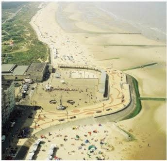
hard structural defense in Wenduine (Belpaeme et al. 2004)
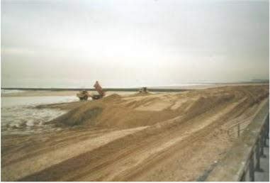
Beach nourishment as soft defense (MDK-department coast)
What made the coast even more popular was the revolution in transport in the 19th century which made a vacation to the sea accessible for almost everyone. With this, apartment buildings popped out of the ground and almost the entire coastline got built up. There are a few natural reserves but nonetheless is our coast seen as rather ugly. The same is true for our ribbon development which is everywhere and clearly indicates a lack of building regulations throughout our history.
Drowned land of Saefinghe
The story of Saeftinghe surely is worth telling. the region next to the Scheldt was set dry in the 13th century and the town existed until 1570. It was very fertile land and was one of the most successful places in the region. In 1570 a disaster called the All Saint's Flood (it happened on the 1st of November) broke many dykes and flooded a lot of the land in the region.
Some of the land around the town was lost, but in 1584, during the Eighty Year's War between the Netherlands and Spain for Dutch independence, soldiers were forced to destroy the last intact dike and the entire region was lost to the sea again.
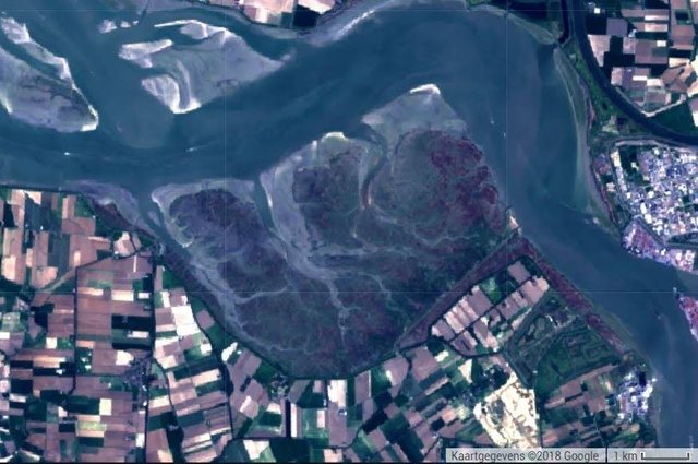
Drowned land of Saeftinghe as seen from space. Image from public datasets, retrieved using the Google Earth Engine.
War
West Flanders has experienced both the first and the second World War. During the first World War it even played an important role and even was the scene for some of the biggest battles. It was the last corner of Belgium where the army could hold the German Von Schlieffen plan. The front stabilized along the Yser river. Two heroic sluiceworkers played an important role as they opened the sluices, flooding the polders and bringing the advancing army.
Many lives were lost and even hundreds of thousands British and Canadian soldiers. Later, red poppies sprang up in the fields that were shredded by artillery and this flower then became a symbol for all the human lives that were lost. It is now exactly 100 years ago this took place and for 4 years there were many commemorations.
A famous poem has been written called "In Flanders Fields" and was the most popular poem of its era according to historian Paul Fussell. If you wish to read this, indeed goose-bumps-giving poem, you can find it here.

Aspects of the poem were even used as propaganda, such as this poster. You can also see the fields of poppies on the empty fields. Image under public domain.
Ypres is also the place were mustard gas was first used on such a large scale, hence the name Yperite.
The Second World War was less impressive and with the German Blitzkrieg, Belgium was subdued in only a few weeks.
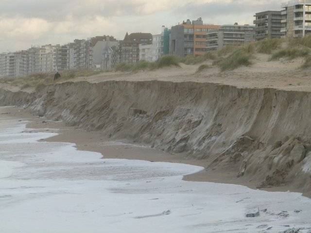
Erosion
Enough of history for now, time for some actual geographical issues. Since the last 50 years erosion has been an important focus. This is a thing that has to be managed constantly since the coast is heavily built-up and it is an important source of income from tourism, has important harbors and protects the agricultural hinterland.
Initially they tried to defend the coast with massive hard engineered structures such as groins, breakwaters, seawalls...) but this only worsens the natural coastal balance. Artificial nourishment (adding sand and dunes) is now a more preferred strategy.
But with the increasing sea level rise the question has to be asked if we can keep up with reinforcing our coast. Is it a good idea to get into an arms race with nature? Each year reports of erosion get more extreme and more expensive to repair.
Coastal erosion at De Panne during storm Xaver in 2013. Picture from Billau, René
But if we can believe the predictions, we could end up in a scenario similar to Duinkerkiaan 2 (Similar to when Romans inhabited these lands). This would also mean losing a majority of our agricultural land and cities. Luckily it won't come that far and we can probably learn a lot from the Dutch who have battled the sea for centuries.
Conclusion
Coastal regions are such magnificent, always changing environments. Ideal topic for an article I thought while walking with the sand between my toes! I hope you found it interesting.
Stay Curious!
Sources
Marian, W., & Frank, M. (2010). IMCORE project: The Belgian Coast Case Study. https://imcore.files.wordpress.com/2009/10/belgian_coast_case_study1.pdf
Belpaeme, K.; Kerckhof, F.; Gheskiere, T. (2004). About "clean" beaches and beach cleaning in Belgium, in: Green, D.R. et al. (Ed.) Littoral 2004: 7th International Symposium. Delivering Sustainable Coasts: Connecting Science and Policy, Aberdeen, Scotland, UK, 20th - 22nd September 2004. Proceedings volume 2. pp. 749-751
Fussell, Paul (2009) [1975], The Great War and Modern Memory (Illustrated Edition), New York: Stirling Publishing, ISBN 0-19-513331-5
Charlier, R. H., & De Meyer, C. P. (1992). Tourism and the coastal zone: The case of Belgium. Ocean and Coastal Management, 18(2–4), 231–240. https://doi.org/10.1016/0964-5691(92)90026-H
https://en.wikipedia.org/wiki/All_Saints%27_Flood_(1570)
https://en.wikipedia.org/wiki/In_Flanders_Fields
https://en.wikipedia.org/wiki/Belgium_in_World_War_I#Yser_Front
https://nl.wikipedia.org/wiki/Verdronken_Land_van_Saeftinghe
Hi @samve! We are @steem-ua, a new Steem dApp, using UserAuthority for algorithmic post curation! In our last Algorithmic Curation Round, consisting of 107 contributions, your post is ranked at #100. The readers like your work! Keep up the good work! Feel free to join our Discord server!