Showery Halloween Seasonably Cool Weekend On Schedule
Showery Halloween Seasonably Cool Weekend On Schedule
Good morning everyone. Clouds have crept back into the area as promised and they're not really going anywhere until some time on Friday. Our showery Halloween and rainy Halloween night is on schedule, as well as a seasonably cool weekend, with nothing extreme temp-wise.
SATELLITE

Tomorrow looks about the same until early to mid afternoon. We'll also add the chance of fog into the mix as warmer air tries to fight back. Once the maritime influence breaks down, we could see a few blue patches and temps will head up into the 65-70 degree range depending on if the sun can peak through long enough.

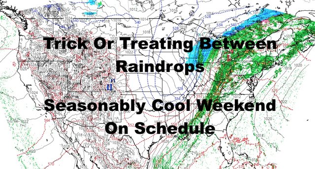
That brings us to Halloween, where a large system will be lurking off to our west. First, a warm front will bring us a round of showers into the area. Since we'll get ourselves into the warm sector of this one, highs may reach the upper 60's to low 70's depending on if we get a decent break from the precipitation.
After the warm front passes, expect the chance of pop up showers at any given time throughout the day. Some of those showers could be heavy in nature, with maybe even a rumble of thunder. The question is, will we get a break in between raindrops to pull off some trick or treating? It's entirely possible, but we have to wait and look at the radar to see how everything unfolds. It's impossible to make that call now with no system knocking on our door.
Regardless of the timing of any perceived "break", steadier and heavier rain will move back in at some point. This is associated with the cold front that'll sweep by Friday morning.
Moderate to heavy rain will come to an end Friday morning, then look for abrupt clearing and sunshine. Unfortunately, our high temps in the 60's will happen early, then temps will sink quickly before sunset and overnight. Lows overnight will be in the near 40 range for the heat island of NYC, but mid to upper 30's are possible in parts of Long Island. It'll also be a rather windy day, with a string southerly fetch at first, then a break, then a strong northwesterly flow developing.

Saturday will start off breezy, then we should calm things down to a steady flow as the day wears on. Sunshine will dominate, but highs will only be in the low to mid 50's. That'll put us 5-8 degrees below average, but nothing extreme. Lows again will range in the near 40 range in NYC, and in the 30's for Long Island. Upstate will also see 30's, but some 20's could also dot the area if the winds stay calm.
I think on Sunday we ramp the winds up again as high pressure begins to march our way, then calm then down again as the core of cool air sits over us on Monday. Highs both days will be in the mid 50's, with bright sunshine and dry conditions.

In the long range, I think we hold onto this fast-paced, active pattern, with vigorous systems 4-7 days apart. Cool air shots will be progressively cooler, but average temps dominate in between. All in all, the Northeast is seeing typical late October/early November weather, but the lower Midwest/Plains are seeing early tastes of winter, not typical for this time of year.
Please note that with regards to any tropical storms or hurricanes, should a storm be threatening, please consult your local National Weather Service office or your local government officials about what action you should be taking to protect life and property.
Posted from my blog with SteemPress : https://www.nycweathernow.com/showery-halloween-seasonably-cool-weekend-on-schedule/