This article is about the Indian state of Tripura. For the mythological bengali city
.jpg) Tripura state (India)
Tripura state (India)
***maharaja bir bikram kishore manikya bahadur (THE KING OF TRIPURA)
.jpg)
Tripura /ˈtrɪpuːrɑː/ is a state in Northeast India. The third-smallest state in the country, it covers 10,491 km2 (4,051 sq mi) and is bordered by Bangladesh to the north,[8] south, and west, and the Indian states of Assam and Mizoram to the east. In 2011 the state had 3,671,032 residents, constituting 0.3% of the country's population.
The area of modern 'Tripura' was ruled for several centuries by the Tripuri dynasty. It was the independent princely state of the Tripuri Kingdom under the protectorate of the British Empire which was known as Hill Tippera[9] while the area annexed and ruled directly by British India was known as Tippera District (present Comilla District).[10] The independent Tripuri Kingdom (or Hill Tippera) joined the newly independent India in 1949. Ethnic strife between the indigenous Tripuri people and the migrant Bengali population due to large influx of Bengali Hindu refugees and settlers from Bangladesh led to tension and scattered violence since its integration into the country of India, but the establishment of an autonomous tribal administrative agency and other strategies have led to peace.
Tripura lies in a geographically disadvantageous location in India, as only one major highway, the National Highway 8, connects it with the rest of the country. Five mountain ranges—Boromura, Atharamura, Longtharai, Shakhan and Jampui Hills—run north to south, with intervening valleys; Agartala, the capital, is located on a plain to the west. The state has a tropical savanna climate, and receives seasonal heavy rains from the south west monsoon. Forests cover more than half of the area, in which bamboo and cane tracts are common. Tripura has the highest number of primate species found in any Indian state. Due to its geographical isolation, economic progress in the state is hindered. Poverty and unemployment continue to plague Tripura, which has a limited infrastructure. Most residents are involved in agriculture and allied activities, although the service sector is the largest contributor to the state's gross domestic product.
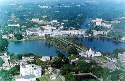
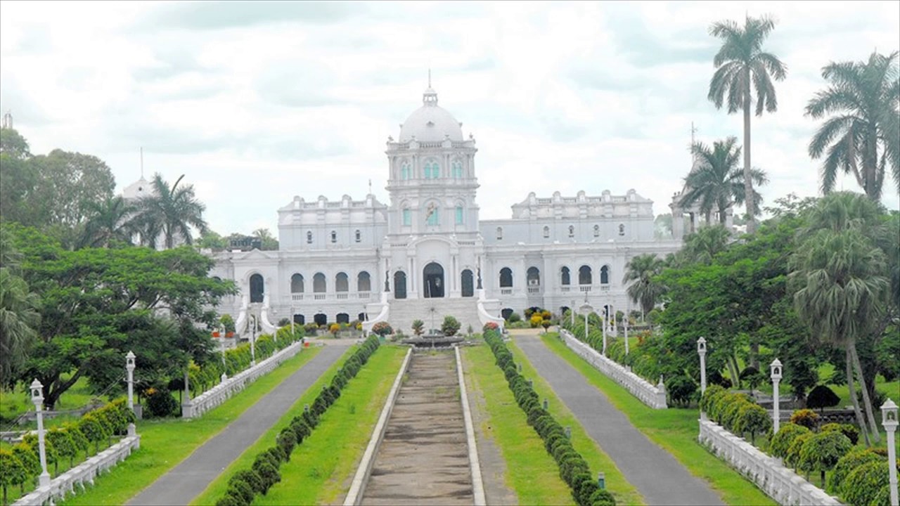
Mainstream Indian cultural elements coexist with traditional practices of the ethnic groups, such as various dances to celebrate religious occasions, weddings and festivities; the use of locally crafted musical instruments and clothes; and the worship of regional deities. The sculptures at the archaeological sites Unakoti, Pilak and Devtamura provide historical evidence of artistic fusion between organised and tribal religions. The Ujjayanta Palace in Agartala was the former royal abode of the Tripuri king.
Etymology[edit]
Further information: Debbarma and Twipra
The Sanskrit name is linked to Tripura Sundari, the presiding deity of the Tripura Sundari Temple at Udaipur, one of the 51 Shakti Peethas (pilgrimage centres of Shaktism),[11][12] and to the legendary tyrant king Tripur, who reigned in the region. Tripur was the 39th descendant of Druhyu, who belonged to the lineage of Yayati, a king of the Lunar Dynasty.[13]
One of the Puranas, the text about the "exploits of Shiva", tells the story of the "sack of Tripura". (Carl Olson – 2007, "Hindu Primary Sources: A Sectarian Reader", p. 414)
However, there have been suggestions to the effect that the origin of the name Tripura is doubtful, raising the possibility that the Sanskritic form is just due to a folk etymology of a Tibeto-Burman (Kokborok) name. Variants of the name include Tripra, Tuipura and Tippera. A Kokborok etymology from twi (water) and pra (near) has been suggested; the boundaries of Tripura extended to the Bay of Bengal when the kings of the Tripra Kingdom held sway from the Garo Hills of Meghalaya to Arakan, the present Rakhine State of Burma; so the name may reflect vicinity to the sea.[11][12][14]
History[edit]
Main article: History of Tripura
See also: Twipra Kingdom, Tripura (princely state), Kings of Tripura, and Tripura Rebellion
Although there is no evidence of lower or middle Paleolithic settlements in Tripura, Upper Paleolithic tools made of fossil wood have been found in the Haora and Khowai valleys.[15] The Indian epic, the Mahabharata; ancient religious texts, the Puranas; and the Edicts of Ashoka – stone pillar inscriptions of the emperor Ashoka dating from the third century BCE – all mention Tripura.[13] An ancient name of Tripura is Kirat Desh (English: "The land of Kirat"), probably referring to the Kirata Kingdoms or the more generic term Kirata.[16]:155 However, it is unclear whether the extent of modern Tripura is coterminous with Kirat Desh.[17] The region was under the rule of the Twipra Kingdom for centuries, although when this dates from is not documented. The Rajmala, a chronicle of Tripuri kings which was first written in the 15th century,[18] provides a list of 179 kings, from antiquity up to Krishna Kishore Manikya (1830–1850),[19]:3[20][21] but the reliability of the Rajmala has been doubted.[22]
.jpg)
King Bir Chandra Manikya with queen Manamohini
The boundaries of the kingdom changed over the centuries. At various times, the borders reached south to the jungles of the Sundarbans on the Bay of Bengal; east to Burma; and north to the boundary of the Kamarupa kingdom in Assam.[18] There were several Muslim invasions of the region from the 13th century onward,[18] which culminated in Mughal dominance of the plains of the kingdom in 1733,[18] although their rule never extended to the hill regions.[18] The Mughals had influence over the appointment of the Tripuri kings.[18]
Tripura became a princely state during British rule in India. The kings had an estate in British India, known as Tippera district or Chakla Roshnabad (now the Comilla district[10] of Bangladesh), in addition to the independent area known as Hill Tippera, the present-day state.[18] Udaipur, in the south of Tripura, was the capital of the kingdom, until the king Krishna Manikya moved the capital to Old Agartala in the 18th century. It was moved to the new city of Agartala in the 19th century. Bir Chandra Manikya (1862–1896) modelled his administration on the pattern of British India, and enacted reforms including the formation of Agartala Municipal Corporation.[23]
Following the independence of India in 1947, Tippera district – the estate in the plains of British India – became a part of East Pakistan, and Hill Tippera remained under a regency council until 1949. The Maharani Regent of Tripura signed the Tripura Merger Agreement on 9 September 1949, as a result of which Tripura became a Part C state of India.[24]:3 It became a Union Territory, without a legislature, in November 1956 and an elected ministry was installed in July 1963.[24]:3 The geographic partition that coincided with the independence of India resulted in major economic and infrastructural setbacks for the state, as road transport between the state and the major cities of India had to follow a more circuitous route. The road distance between Kolkata and Agartala before the partition was less than 350 km (220 mi), and increased to 1,700 km (1,100 mi), as the route now avoided East Pakistan.[25] The geo-political isolation was aggravated by an absence of rail transport.[26][27]:93
Some parts of the state were shelled by the Pakistan Army during the Indo-Pakistani War of 1971. Following the war, the Indian government reorganised the North East region to ensure effective control of the international borders – three new states came into existence on 21 January 1972:[28] Meghalaya, Manipur, and Tripura.[28] Since the partition of India, many Hindu Bengalis have migrated to Tripura as refugees from East Pakistan;[24]:3–4 settlement by Hindu Bengalis increased at the time of the Bangladesh Liberation War of 1971. Hindu Bengalis migrated to Tripura after 1949 to escape religious persecution in Muslim majority East Pakistan. Before independence, most of the population was indigenous;.[24]:9 Ethnic strife between the Tripuri tribe and the predominantly immigrant Bengali community led to scattered violence,[29] and an insurgency spanning decades. This gradually abated following the establishment of a tribal autonomous district council and the use of strategic counter-insurgency operations,[30] aided by the overall socio-economic progress of the state. Tripura remains peaceful, as of 2016.[31]
Geography[edit]
Green agricultural field, with a hill range far in the background
Rice is grown on Tripura's alluvial plains, which include lungas, the narrow valleys that are found mainly in the west of the state.
Tripura is a landlocked state in North East India, where the seven contiguous states – Arunachal Pradesh, Assam, Manipur, Meghalaya, Mizoram, Nagaland and Tripura – are collectively known as the Seven Sister States. Spread over 10,491.69 km2 (4,050.86 sq mi), Tripura is the third-smallest among the 29 states in the country, behind Goa and Sikkim. It extends from 22°56'N to 24°32'N, and 91°09'E to 92°20'E.[24]:3 Its maximum extent measures about 178 km (111 mi) from north to south, and 131 km (81 mi) east to west. Tripura is bordered by the country of Bangladesh to the west, north and south; and the Indian states of Assam to the north east; and Mizoram to the east.[24]:3 It is accessible by national highways passing through the Karimganj district of Assam and Mamit district of Mizoram.[32]
Topography[edit]
The physiography is characterised by hill ranges, valleys and plains. The state has five anticlinal ranges of hills running north to south, from Boromura in the west, through Atharamura, Longtharai and Shakhan, to the Jampui Hills in the east.[33]:4 The intervening synclines are the Agartala–Udaipur, Khowai–Teliamura, Kamalpur–Ambasa, Kailasahar–Manu and Dharmanagar–Kanchanpur valleys.[33]:4 At an altitude of 939 m (3,081 ft), Betling Shib in the Jampui range is the state's highest point.[24]:4 The small isolated hillocks interspersed throughout the state are known as tillas, and the narrow fertile alluvial valleys, mostly present in the west, are called lungas.[24]:4 A number of rivers originate in the hills of Tripura and flow into Bangladesh.[24]:4 The Khowai, Dhalai, Manu, Juri and Longai flow towards the north; the Gumti to the west; and the Muhuri and Feni to the south west.[33]:73
The lithostratigraphy data published by the Geological Survey of India dates the rocks, on the geologic time scale, between the Oligocene epoch, approximately 34 to 23 million years ago, and the Holocene epoch, which started 12,000 years ago.[33]:73–4 The hills have red laterite soil that is porous. The flood plains and narrow valleys are overlain by alluvial soil, and those in the west and south constitute most of the agricultural land.[24]:4 According to the Bureau of Indian Standards, on a scale ranging from I to V in order of increasing susceptibility to earthquakes, the state lies in seismic zone V.[34]
Climate[edit]
The state has a tropical savanna climate, designated Aw under the Köppen climate classification. The undulating topography leads to local variations, particularly in the hill ranges.[35] The four main seasons are winter, from December to February; pre-monsoon or summer, from March to April; monsoon, from May to September; and post-monsoon, from October to November.[36] During the monsoon season, the south west monsoon brings heavy rains, which cause frequent floods.[24]:4[33]:73 The average annual rainfall between 1995 and 2006 ranged from 1,979.6 to 2,745.9 mm (77.94 to 108.11 in).[37] During winter, temperatures range from 13 to 27 °C (55 to 81 °F), while in the summer they fall between 24 and 36 °C (75 and 97 °F).[36] According to a United Nations Development Programme report, the state lies in "very high damage risk" zone from wind and cyclones.[38]
Economy[edit]
Gross State Domestic Product at Constant Prices
(2004–05 base)[68]
figures in crores Indian rupee
Year Gross State
Domestic Product
2004–05 8,904
2005–06 9,482
2006–07 10,202
2007–08 10,988
2008–09 11,596
2009–10 12,248
2010–11 12,947
Tripura's gross state domestic product for 2010–11 was ₹129.47 billion (US$2.0 billion) at constant price (2004–05),[68] recording 5.71 per cent growth over the previous year. In the same period, the GDP of India was ₹48,778.42 billion (US$760 billion), with a growth rate of 8.55 per cent.[68] Annual per capita income at current price of the state was ₹38,493 (US$600), compared to the national per capita income ₹44,345 (US$690).[69] In 2009, the tertiary sector of the economy (service industries) was the largest contributor to the gross domestic product of the state, contributing 53.98 per cent of the state's economy compared to 23.07 per cent from the primary sector (agriculture, forestry, mining) and 22.95 per cent from the secondary sector (industrial and manufacturing).[69] According to the Economic Census of 2005, after agriculture, the maximum number of workers were engaged in retail trade (28.21 per cent of total non-agricultural workforce), followed by manufacturing (18.60 per cent), public administration (14.54 per cent), and education (14.40 per cent).[70]
Tripura is an agrarian state with more than half of the population dependent on agriculture and allied activities.[71] However, due to hilly terrain and forest cover, only 27 per cent of the land is available for cultivation.[71] Rice, the major crop of the state, is cultivated in 91 per cent of the cropped area.[71] According to the Directorate of Economics & Statistics, Government of Tripura, in 2009–10, potato, sugarcane, mesta, pulses and jute were the other major crops cultivated in the state.[72] Jackfruit and pineapple top the list of horticultural products.[72] Traditionally, most of the indigenous population practised jhum method (a type of slash-and-burn) of cultivation. The number of people dependent on jhum has declined over the years.[73]:37–9
.JPG)
Green paddy field with a few huts at a distance
Rice is the major crop in Tripura and accounts for 91 per cent of the land under cultivation.
Pisciculture has made significant advances in the state. At the end of 2009–10, the state produced a surplus of 104.3 million fish seeds.[74] Rubber and tea are the important cash crops of the state. Tripura ranks second to Kerala in the production of natural rubber in the country.[75] The state is known for its handicraft, particularly hand-woven cotton fabric, wood carvings, and bamboo products. High quality timber including sal, garjan, teak and gamar are found abundantly in the forests of Tripura. Tata Trusts signed a pact with Government of Tripura in July 2015 to improve fisheries and dairy in the state.[76]
Per Capita Income with 2004–05 Base
Year Tripura India
2004–05 24,394 24,095
2005–06 26,668 27,183
2006–07 29,081 31,080
2007–08 31,111 35,430
2008–09 33,350 40,141
2010–11 33,493 44,345
The industrial sector of the state continues to be highly underdeveloped – brickfields and tea industry are the only two organised sectors.[70] Tripura has considerable reservoirs of natural gas.[33]:78–81 According to estimates by Oil and Natural Gas Corporation (ONGC), the state has 400 billion metres3 reserves of natural gas, with 16 billion metres3 is recoverable.[75] ONGC produced 480 million metres3 natural gas in the state, in 2006–07.[75] In 2011 and 2013, new large discoveries of natural gas were announced by ONGC.[77] Tourism industry in the state is growing – the revenue earned in tourism sector crossed ₹10 million (US$160,000) for the first time in 2009–10, and surpassed ₹15 million (US$230,000) in 2010–11.[78] Although Bangladesh is in a trade deficit with India, its export to Tripura is significantly more than import from the state; a report in the newspaper The Hindu estimated Bangladesh exported commodities valued at about ₹3.5 billion (US$55 million) to the state in 2012, as opposed to "very small quantity" of import.[79] Alongside legal international trade, unofficial and informal cross-border trade is rampant.[80] In a research paper published by the Institute of Developing Economies in 2004, the dependence of Tripura's economy on that of Bangladesh was emphasised.[81]:313
The economy of Tripura can be characterised by high rate of poverty, low capital formation, inadequate infrastructure facilities, geographical isolation and communication bottlenecks, inadequate exploration and use of forest and mineral resources, slow industrialisation and high unemployment. More than 50% of the population depends on agriculture for sustaining their livelihood.[82] However agriculture and allied activities to Gross State Domestic Production (GSDP) is only 23%, this is primarily because of low capital base in the sector. Despite the inherent limitation and constraints coupled with severe resources for investing in basic infrastructure, this has brought consistence progress in quality of life and income of people cutting across all sections of society. The state government through its Tripura Industrial Policy and Tripura Industrial Incentives Scheme, 2012, has offered heavy subsidies in capital investment and transport, preferences in government procurement, waivers in tender processes and fees, yet the impact has been not much significant beyond a few industries being set up in the Bodhjungnagar Industrial Growth Center.[83]
.jpg)
The Planning Commission estimates the poverty rate of all North East Indian states by using head count ratio of Assam (the largest state in North East India). According to 2001 Planning Commission assessment, 22 per cent of Tripura's rural residents were below the poverty line. However, Tripura government's independent assessment, based on consumption distribution data, reported that, in 2001, 55 per cent of the rural population was below the poverty line.[70] Geographic isolation and communication bottleneck coupled with insufficient infrastructure have restricted economic growth of the state.[71] High rate of poverty and unemployment continues to be prevalent.[71]
.jpg)
Transport[edit]
Air
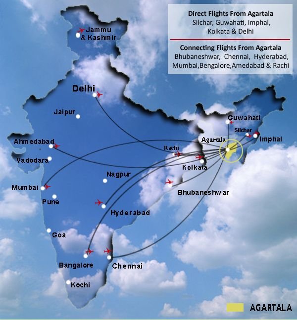
Agartala airport
Agartala Airport, located 12 km northwest of Agartala at Singerbhil, is the second busiest airport in northeast India after Guwahati. There are direct flights to Kolkata, Imphal, Delhi, Silchar, Aizwal, Guwahati, Bangalore, Chennai, Ahmedabad and Mumbai. The major airlines are Air India, Jet Airways (Operating Codeshare and connect Flights), Indigo Airlines and Spicejet. Passenger helicopter services are available between the capital and major towns (Kailashahar, Dharmanagar) as well as to more remote areas such as Kanchanpur and Gandacherra.[84]
.jpg)
Railway
Agartala Railway Station
Agartala, came on India's railway map with the advent of the railways in the subcontinent in 1853 but the link was broken when India was partitioned in 1947. Railway service was established in Tripura in 1964 by constructing 1,000 mm (3 ft 3 3⁄8 in) metre gauge metre gauge track from Lumding in Assam to Dharmanagar and Kailasahar in Tripura but the track did not connect the state capital Agartala. Rail transport was absent in the state until 2008–09 when the railway track was extended to the capital Agartala.[84] The metre gauge rail track was connected to 1,676 mm (5 ft 6 in) broad gauge at Lumding. The major railways stations in this line are in Agartala, Dharmanagar, and Kumarghat. This metre gauge track was converted to 1,676 mm (5 ft 6 in) broad gauge in 2016 and now trains run from Agartala to Calcutta and Delhi. The total length of this railway track in Tripura state is 153 km. It is a single line without electrification.
Extension of the railway line from Agartala to the southernmost town of Sabroom at Bangladesh border is in progress. The 43 km long track from Agartala to Udaipur-Tripura railway station (station code UDPU) near Mata Tripura Sundari Temple has been commissioned and two trains run on this section. The 70 km long section from Udaipur-Tripura to Sabroom on the bank of Feni River, which separates Tripura from Bangladesh, is being constructed as of 2017.[84]
A new railway line is being laid westwards from Agartala to Akhaura in Bangladesh. This will reduce the distance between Agartala and Calcutta by over 1000 km and provide rail access to Chittagong port.
Road
The border post between Bangladesh and India in Akhaura
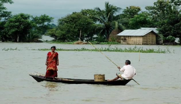
Only one major road, the National Highway 8 (NH-8), connects Tripura to the rest of India.[84] Starting at Sabroom in southern Tripura, it heads north to the capital Agartala, turns east and then north-east to enter the state of Assam. Locally known as "Assam Road", the NH-8 is often called the lifeline of Tripura.[84] However, the highway is single lane and of poor quality; often landslides, rains or other disruptions on the highway cut the state off from its neighbours.[33]:73[73]:8 Another National Highway, NH 108, connects the town Panisagar in North Tripura District with Aizawl, Mizoram.[32] The Tripura Road Transport Corporation is the government agency overlooking public transport on road. A hilly and land-locked state, Tripura is dependent mostly on roads for transport.[84] The total length of roads in the state is 16,931 km (10,520 mi) of which national highways constitute 88 km (55 mi) and state highways 689 km (428 mi), as of 2009–10.[84] Residents in rural areas frequently use waterways as a mode of transport.[85]:140
Tripura has an 856 km (532 mi) long international border with Bangladesh, of which 730.5 km (453.9 mi) is fenced, as of 2012.[86] Several locations along the border serve as bilateral trading points between India and Bangladesh, such as Akhaura near Agartala, Raghna, Srimantpur, Belonia, Khowai and Kailasahar.[79] A bus service exists between Agartala and Dhaka, the capital of Bangladesh.[87][88] In 2013, the two countries signed an agreement to establish a 15 km (9.3 mi) railway link between Agartala and the Akhaura junction of Bangladesh.[89] Citizens of both countries need visa to legally enter the other country; however, illegal movement and smuggling across the border are widespread.[81]:314[90]
Media and communication[edit]
Doordarshan (DD) has a television station in Agartala. Akash Tripura is one of the first television channels in Agartala. It is a full-time Agartala-based news channel. Other full-time based channels are Headlines Tripura,[91] Awaaz, Prime Television Network.
As of 2014, 56 daily and weekly newspapers are published in Tripura.[92] Most of the newspapers are published in Bengali, except for one Kokborok daily (Hachukni Kok), one Manipuri weekly (Marup), two English dailies and three bilingual weeklies.[92] Notable dailies include Ajkal Tripura, Daily Desher Katha, Dainik Sambad and Syandan Patrika.[92] and popular news portal www.tripurachronicle.in In a study by Indian Institute of Mass Communication in 2009, 93 per cent of the sampled in Tripura rated television as very effective for information and mass education.[93] In the study, 67 per cent of the sampled listened to radio and 80–90 per cent read newspaper.[93] Most of the major Indian telecommunication companies are present in the state, such as Airtel, Aircel, Vodafone, Reliance, Jio, Idea and BSNL. Mobile connections outnumber landline connections by a wide margin. As of 2011, the state-controlled BSNL has 57,897 landline subscribers and 325,279 GSM mobile service connections.[84] There are 84 telephone exchanges (for landlines) and 716 post offices in the state, as of 2011.[84]
Electricity[edit]
Till 2014, Tripura was a power deficit state. In late 2014, Tripura reached surplus electricity production capacity by using its recently discovered natural gas resources, and installing high efficiency gas turbine power plants. The state has many power-generating stations. These are owned by Tripura State Electricity Corporation (TSECL), natural gas-powered thermal power stations at Rokhia and Baramura, and the ONGC Tripura Power Company in Palatana.[94] The ONGC plant has a capacity of 726.6 MW, with the second plant's commissioning in November 2014.[95][96] It is the largest individual power plant in the northeast region.[97]
The state also has a hydro power station on the Gumti River. The combined power generation from these three stations is 100–105 MW.[98] The North Eastern Electric Power Corporation (NEEPCO) operates the 84 MW Agartala Gas Turbine Power Plant near Agartala.[98] As of November 2014, another thermal power plant is being built at Monarchak.[99]
With the newly added power generation capacity, Tripura has with enough capacity to supply all seven sister states of northeast India, as well export power to neighbouring countries such as Bangladesh.[100] With recent discoveries, the state has abundant natural gas reserves to support many more power generation plants, but lacks pipeline and transport infrastructure to deliver the fuel or electricity to India's national grid.
.jpg)
.jpg)
Irrigation and fertilizers[edit]
As of 2011, 255,241 hectares (985 sq mi) of land in Tripura cultivable, of which 108,646 hectares (419 sq mi) has the potential to be covered by irrigation projects. However, only 74,796 hectares (289 sq mi) is irrigated.[101] The state lacks major irrigation projects; it depends on medium-sized projects sourced from Gumti, Khowai (at Chakmaghat) and Manu rivers, and minor projects administered by village-level governing bodies that utilise tube wells, water pumps, tanks and lift irrigation.[101]
ONGC and Chambal Fertilizers & Chemicals are jointly building a fertiliser plant to leverage ONGC's natural gas discoveries in Tripura.[102] Expected to be in operation by 2017, the 1.3 million tonnes per year plant will supply the northeastern states.[103]
.jpg)
.jpg)
.jpg)
Drinking water[edit]
Drinking Water and Sanitation (DWS) wing of Public Works Department manages the drinking water supply in the state. Schools and Anganwadi Centers have been specifically targeted to improve drinking water supply as well as attendance to these institutions. Many areas of Tripura have the problem of excessive iron content in ground water requiring installation of Iron Removal Plants (IRP). Tripura State has received the best State Award for Water & Sanitation under the category of Small States in the IBN7 Diamond State Award function for doing commendable work to provide drinking water supply to the people with sparsely distributed tribal population in hamlets of hilly region of the State. However, a study by the DWS Department found depleting water table and excessive contamination.[104] Still, packaged drinking water under brands "Tribeni", "Eco Freshh", "Blue Fina", "Life Drop" and "Aqua Zoom" among others is manufactured and sold in the state. Filters of many types and brands, in addition to locally manufactured ceramic type filters, are sold in the state although their acceptance in rural areas is less.
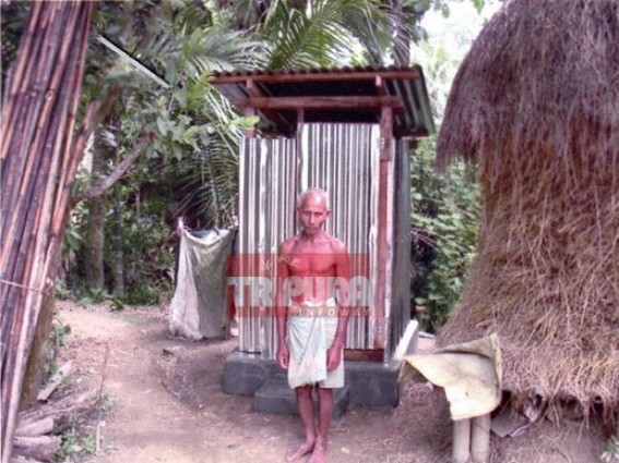
Sanitation[edit]
Tripura has high incidence of open defecation, especially in the interior hilly and forest areas. The state has extensively implemented Nirmal Bharat Abhiyan and currently the Swachh Bharat Abhiyan and convergence with MGNREGS to address this problem. Schools and Anganwadi Center are focussed to provide with urinals and latrines, separate for boys and girls aling with baby friendly toilets in Anganwadi Centers to inculcate the habit of using sanitary latrines in young age. However many toilets lie dysfuncational due to lack of maintenance and damage. Earlier schemes of providing plastic squatting plates, free of cost to people, has not produced results as most of them lie unused as many people cannot afford to construct a toilet. Open defecation has created problems of diarrhoea and vulnerability to malaria. The Chief Minister of Tripura has envisioned to make the state Open Defecation Free (ODF) by 2017.
.jpg)
.jpg)
Education[edit]
Main article: Education in Tripura
See also: List of institutions of higher education in Tripura
Classrooms made of bamboo in a school
Classrooms built of bamboo in a school. In 2010–11, Tripura had 4,455 schools run by the state government or private organisations.[105] Instruction is mainly in English or Bengali.
Schools in Tripura are run by the state government elected by the people, TTAADC and private organisations, which include religious institutions. Instruction in schools is mainly in English or Bengali, though Kokborok and other regional languages are also used. Some of the special schools include Jawahar Navodaya Vidyalaya, Kasturba Gandhi Balika Vidyalaya, residential schools run by Tripura Tribal Welfare Residential Educational Institutions Society (TTWREIS),[106] missionary organisations like St. Paul's, St. Arnold's, Holy Cross, Don Bosco, St. John's etc. There are also many Preschools mostly located in cities like Kidzee Agartala at 79 tilla, GB in Agartala. The schools are affiliated to the Council for the Indian School Certificate Examinations (CISCE), the Central Board for Secondary Education (CBSE), the National Institute of Open Schooling (NIOS) or the Tripura Board of Secondary Education.[107] Under the 10+2+3 plan, after completing secondary school, students typically enroll for two years in a junior college or in a higher secondary school affiliated either to the Tripura Board of Secondary Education or to other central boards. Students choose from one of the three streams—liberal arts, commerce or science.[107] As in the rest of India,[108] after passing the Higher Secondary Examination (the grade 12 examination), students may enroll in general degree programs such as bachelor's degree in arts, commerce or science, or professional degree programs such as engineering, law or medicine.
According to the Economic Review of Tripura 2010–11, Tripura has a total of 4,455 schools, of which 2,298 are primary schools.[105] The total enrolment in all schools of the state is 767,672.[105] Tripura has one Central University (Tripura University) one State University namely M. B. B. University ([2]) and one private university (a branch of the Institute of Chartered Financial Analysts of India). There are 15 general colleges, three engineering colleges (Tripura Institute of Technology, National Institute of Technology, Agartala and NIEILT, Agartala), two medical colleges (Agartala Government Medical College[109] and Tripura Medical College[110]), three nursing or paramedical colleges, three polytechnic colleges, one law college, one Government Music College, one College of Fisheries, Institute of Advance Studies in Education, one Regional College of Physical Education at Panisagar and one art college.[105][111] Tripura University also houses the IGNOU Agartala Regional Center.
.jpg)
.jpg)
Healthcare[edit]
Main article: Healthcare in Tripura
Health indices as of 2010[112]
Indicator Tripura India
Birth rate 14.9 22.1
Death rate 5.0 7.2
Infant mortality rate 27 47
Total fertility rate 2.2 2.7
Natural growth rate 9.9 14.9
Healthcare in Tripura features a universal health care system run by the Ministry of Health & Family Welfare of the Government of Tripura.[113] The health care infrastructure is divided into three tiers – the primary health care network, a secondary care system comprising district and sub-divisional hospitals and tertiary hospitals providing speciality and super speciality care. As of 2010–11, there are 17 hospitals, 11 rural hospitals and community health centres, 79 primary health centres, 635 sub-centres/dispensaries, 7 blood banks and 7 blood storage centres in the state.[114] Homeopathic and Ayurvedic styles of medicine are also popular in the state.[114] The National Family Health Survey – 3 conducted in 2005–06 revealed that 20 per cent of the residents of Tripura do not generally use government health facilities, and prefers private medical sector.[115] This is overwhelmingly less compared to the national level, where 65.6 per cent do not rely on government facilities.[115] As in the rest of India, Tripura residents also cite poor quality of care as the most frequent reason for non-reliance over public health sector. Other reasons include distance of the public sector facility, long waiting time, and inconvenient hours of operation.[115] As of 2010, the state's performance in major public health care indices, such as birth rate, infant mortality rate and total fertility rate is better than the national average.[112] The state is vulnerable to epidemics of Malaria, Diarrhea, Japanese Encephalitis and Meningitis. In summer 2014 the state witnessed a major Malaria outbreak.[116]
Demographics[edit]
Population[edit]
Population growth[117]
Census Population %±
1951 639,000 —
1961 1,142,000 78.7%
1971 1,556,000 36.3%
1981 2,053,000 31.9%
1991 2,757,000 34.3%
2001 3,199,203 16%
2011 3,671,032 14.7%
Tripura ranks second to Assam as the most populous state in North East India. According to the provisional results of 2011 census of India, Tripura has a population of 3,671,032 with 1,871,867 males and 1,799,165 females.[118] It constitutes 0.3 per cent of India's population. The sex ratio of the state is 961 females per thousand males,[118] higher than the national ratio 940. The density of population is 350 persons per square kilometre.[119] The literacy rate of Tripura in 2011 was 87.75 per cent,[118] higher than the national average 74.04 per cent, and third best among all the states.
Tripura ranked 6th in Human Development Index (HDI) among 35 states and union territories of India, according to 2006 estimate by India's Ministry of Women and Child Development; the HDI of Tripura was 0.663, better than the all-India HDI 0.605.[120]
In 2011, the police in Tripura recorded 5,803 cognisable offences under the Indian Penal Code, a number second only to Assam (66,714) in North East India.[121] The crime rate in the state was 158.1 per 100,000 people, less than the all-India average of 192.2.[122] However, 2010 reports showed that the state topped all the states for crime against women, with a rate of 46.5 per 100,000 people, significantly more than the national rate of 18.[123]
Tripuri children preparing for a dance performance
Tripuri children preparing for a dance performance. The Tripuri, a Tibeto-Burman ethnic group that originated near the upper courses of Yangtze River and Yellow River in China, form about 30 per cent of the state's population.[29][124]
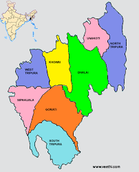
Ethnic groups[edit]
In the 2001 census of India, Bengalis represented almost 70 per cent of Tripura's population while the Tripuri population amounted to 30 per cent.[124] The state's "scheduled tribes", historically disadvantaged groups of people recognised by the country's constitution, consist of 19 ethnic groups and many sub-groups,[125] with diverse languages and cultures. In 2001, the largest such group was the Kokborok-speaking Tripuris, which had a population of 543,848, representing 17.0 per cent of the state's population and 54.7 per cent of the "scheduled tribe" population.[124] The other major groups, in descending order of population, were the Reang (16.6 per cent of the indigenous population), Jamatia (7.5 per cent), Chakma (6.5 per cent), Halam (4.8 per cent), Mog (3.1 per cent), Munda (1.2 per cent), Kuki (1.2 per cent) and Garo (1.1 per cent).[124]
Languages[edit]
Main article: Languages of Tripura
Languages of Tripura in 2001[126][127][128]
Bengali (67.14%)
Tripuri (Kokborok) (25.46%)
Hindi (1.68%)
Kuki (1.2%)
Mogh (0.9%)
Others (3.62%)
Bengali is the most widely spoken language. Kokborok is a prominent language among the Tripura tribes. Several other languages such as Mog, Odia, Bishnupriya Manipuri, Manipuri, Halam, Kuki, Garo and Chakma belonging to Indo-European and Sino-Tibetan families are spoken in the state.[4] Saimar, a nearly extinct language, is spoken by only four people in one village, as of 2012.[129]
Religion[edit]
Religion in Tripura (2011)[130]
.jpg)
Hinduism (83.4%)
Islam (8.6%)
Christianity (4.35%)
Buddhism (3.41%)
Sikhism (0.02%)
Jainism (0.02%)
Other or no religion (0.2%)
According to 2011 census, Hinduism is the majority religion in the state, followed by 83.4 per cent of the population.[131] Muslims make up 8.6 per cent of the population, Christians 4.35 per cent, and Buddhists 3.41 per cent.[131] Mogs (Barua & Mutsuddy also comes under Mog community) and Chakmas are the followers of Buddhism in Tripura.
Christianity is chiefly followed by members of the Lushai, Kuki, Garo, Tripuri, Halam tribes and as per 2011 census has 159,882 adherents.[85]:135–6
Culture[edit]
See also: Culture of Tripura, Bengali culture, and Tripuri culture
A man and a woman in traditional Tripuri dress
A couple in traditional Tripuri costume.
The diverse ethno-linguistic groups of Tripura have given rise to a composite culture.[132][133] The dominant ethnic groups are Bengali, Tripuri (Debbarma, Tripura, Jamatia, Reang, Noatia, Koloi, Murasing, Chakma, Halam, Garo, Kuki, Mizo, Uchoi, Dhamai, Roaza, Mogh, Manipuri, and other tribal groups such as Munda, Oraon and Santhal who migrated in Tripura as a tea labourers.[125] Bengali people represent the largest ethno-linguist community of the state. Bengali culture, as a result, is the main indigenous, non-Tripura culture. Indeed, many elite tribal families which reside in towns have actively embraced Bengali culture and language in the past, but in today's generation more Tripuris are embracing their culture.[134] The Tripuri kings were great patrons of Bengali culture, especially literature;[134] Bengali language was the language of the court.[135] Elements of Bengali culture, such as Bengali literature, Bengali music, and Bengali cuisine are widespread, particularly in the urban areas of the state.[134][136]:110[137]
Tripura is noted for bamboo and cane handicrafts.[133] Bamboo, wood and cane are used to create an array of furniture, utensils, hand-held fans, replicas, mats, baskets, idols and interior decoration materials.[27]:39–41[138] Music and dance are integral to the culture of the state. Some local musical instruments are the sarinda, chongpreng (both string instruments), and sumui (a type of flute).[16]:344–5 Each indigenous community has its own repertoire of songs and dances performed during weddings, religious occasions, and other festivities. The Tripuri and Jamatia people perform goria dance during the Goria puja. Jhum dance (also called tangbiti dance), lebang dance, mamita dance, and mosak sulmani dance are other Tripuri dance forms.[139] Reang community, the second largest scheduled tribe of the state, is noted for its hojagiri dance that is performed by young girls balanced on earthen pitchers.[139] Bizhu dance is performed by the Chakmas during the Bizhu festival (the last day of the month of Chaitra in Hindu calendar). Other dance forms include wangala dance of the Garo people, hai-hak dance of the Halam branch of Kuki people, and sangrai dance and owa dance of the Mog.[139] Alongside such traditional music, mainstream Indian musical elements such as Indian classical music and dance, Rabindra Sangeet are also practised.[140] Sachin Dev Burman, a member of the royal family, was a maestro in the filmi genre of Indian music.[141]
Durga Puja is the major festival of Tripura
Hindus believe that Tripureshwari is the patron goddess of Tripura and an aspect of Shakti.[19]:30 Durga Puja, Kali Puja, Dolyatra, Ashokastami and the worship of the Chaturdasha deities are important festivals in the state. Some festivals represent confluence of different regional traditions, such as Ganga puja, Garia puja, Kharchi puja and Ker puja.[142][143] Unakoti, Pilak and Devtamura are historic sites where large collections of stone carvings and rock sculptures are noted.[133][144] Like Neermahal is a cultural Water Palace of this state. Sculptures are evidence of the presence of Buddhist and Brahmanical orders for centuries, and represent a rare artistic fusion of traditional organised religions and tribal influence.[145][146][147] The State Museum in the Ujjayanta Palace in Agartala has impressive galleries that depict the history and culture of Tripura through pictures, videos and other installations.
Tourism[edit]
Within its small geographical area, Tripura offers plenty of attractions for the tourists in the form of magnificent palaces ( Ujjayanta Palace and Kunjaban Palace at Agartala and Neermahal – Lake Palace at Melaghar ), splendid rock-cut carvings and stone images ( Unakoti near Kailashahar, Debtamura near Amarpur and Pilak in Belonia Sub-divisions ), important temples of Hindus and Buddhists including the famous Mata Tripureswari temple ( one of the 51 Pithasthans as per Hindu mythology ) at Udaipur, vast natural as well as artificial lakes namely Dumboor lake in Gandacherra subdivision, Rudrasagar at Melaghar, Amarsagar, Jagannath Dighi, Kalyan Sagar, etc. at Udaipur, the beautiful hill station of Jampui hill bordering Mizoram, wild life sanctuaries at Sepahijala, Gumti, Rowa and Trishna, eco parks created by forest department at Manu, Baramura, Ambassa and rich cultural heritage of Tribals, Bengalis and Manipuri communities residing in the state. The main attractions in Agartala are Ujjayanta Palace, State Museum, Heritage Park, Tribal Museum, Sukanta Academy, M.B.B. College, Laxminarayan Temple, Uma Maheswar Temple, Jagannath Temple, Benuban Bihar, Gedu Mian Mosque, Malancha Niwas, Rabindra Kanan, Purbasha, Handicrafts Designing Centre, Fourteen Goddess Temple, Portuguese Church etc.[148]
So its very helpful to enjoy with family ......bellow list
***Ujjayanta Palace in Agartala-
*** Nirmahal
.jpg)
.jpg)
The most beautiful thing we can experience is the mysterious. It is the source of all true art and science.
- Albert Einstein
Congratulations @narayan57! You have completed some achievement on Steemit and have been rewarded with new badge(s) :
Click on any badge to view your own Board of Honor on SteemitBoard.
For more information about SteemitBoard, click here
If you no longer want to receive notifications, reply to this comment with the word
STOP