30 Interesting Facts About Google Earth and Maps
Here are 30 Interesting Facts About Google Earth and Maps.
1-5 Interesting Facts About Google Earth and Maps
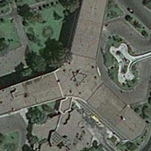
Iran’s largest airport had a Star of David embedded into its roof for 30 years before it was discovered on Google Earth. – Source
Bahrain’s government banned Google Earth because it allowed Bahraini citizens to see vast tracts of royal-owned land and their palaces next to poor and overcrowded Shi’ite villages – Source
Tribes in the Amazon are currently using technology like GPS and Google Earth to map their lands, monitor for illegal logging and mining, and maintain ties to their history and cultural traditions including knowledge of medicinal plants – Source
Google Earth has a built in Flight Simulator. – Source
A satellite archaeological researcher, Angela Micol, discovered some lost Egyptian pyramids using Google Earth – Source
6-10 Interesting Facts About Google Earth and Maps
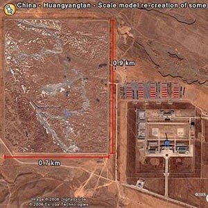
In June 2006, a Google Earth user discovered a very detailed 1:500 scale terrain model of a disputed border region between India and China near a Chinese military complex. It is 3,000 × 2,300 ft in size – Source
Google Earth was originally called Earth Viewer and was created by Keyhole, Inc., a company who were partially funded by the CIA via venture capital firm In-Q-Tel that invests in high-tech companies for the sole purpose of keeping the CIA equipped with the latest in information technology. – Source
The 9/11 terrorist attacks can be viewed with Google Earth’s historical imagery – Source
There is a nonexistent city in West Lancashire, England that shows up on Google Earth and Google Maps. This nonexistent towns is named Argleton in those maps. – Source
The largest natural bridge on earth was virtually unknown to the rest of the world, until it was observed on Google maps. – Source
11-15 Interesting Facts About Google Earth and Maps

Many undersea wrecks, including the Titanic, can be seen from Google Earth. – Source
There is a rainforest in Africa nicknamed the ‘Google Forest’ because it was discovered by scientists using Google Earth – Source
Google Earth’s default center point is its author’s (Brian McClendon) home at Lawrence, Kansas – Source
Swiss Police used Google Earth to find a two acre weed farm – Source
Google uses our phones (with permission) to collect traffic data for Google Maps. – Source
16-20 Interesting Facts About Google Earth and Maps

Google takes advantage of the reCAPTCHA system by getting people to decode pictures from Street View for Google Maps – Source
With Google’s Maps framework and a bit of Javascript, you can see what would happen if a nuclear bomb goes off in your city. – Source
People are using Google Maps to make others aware of dangerous landmine fields in Kosovo – Source
A 1,000 year old “fish trap” made of stones was found off the British coast with Google Maps – Source
Google Maps has many “Copyright Easter Eggs”. These are fake street features that are inserted so that if you attempt to copy the map then the copyright holder can prove you copied it. – Source
21-25 Interesting Facts About Google Earth and Maps

When Fiat discovered that Google’s street view car was mapping Sodertalje, Sweden, they sent a Fiat to tail it for 30 miles, and have it captured on street view in front of Volkswagen’s headquarters. – Source
There are 51 things you aren’t allowed to see on Google Maps. – Source
If you search for “homes” in Google maps, it returns all the homes in the area for sale with their price. – Source
Searching for ‘*’ in Google Maps shows you all the local businesses.
Nicaraguan troops once accidentally marched into Costa Rica, destroyed a protected forest, dredged the San Juan river, and dumped all the stuff they scooped out of it into Costa Rican territory, all because their commander used Google maps when planning, instead of military charts. – Source
26-30 Interesting Facts About Google Earth and Maps
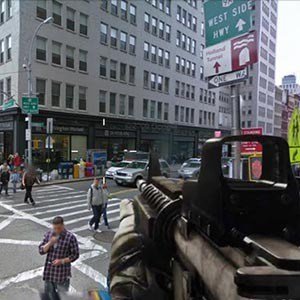
A company made a FPS game with Google Street View where you can walk around and shoot people. – Source
When you press number 3 while in Google street view you are presented with red-cyan 3D view.
There is a map of every recent mass animal death on Google Maps – Source
If you want to have your house blurred on Google Street View, all you have to do is request it. – Source
You can see where the Google Street View cars are currently driving. – Source