Where Eagles Fly : Red Rock & Potosi Mountain ~ Part 1 ~ Around Potosi Mountain to Lovell Canyon
This is the first of a 3 part post series on my exploration flight around the Spring Mountains and Red Rock Canyon area in the wilderness of Nevada, west of Las Vegas.
Part of my goal for this journey was to illustrate the beautifully wild places that exist within a short distance from a major metropolitan area such as Las Vegas. So many people state that we are living in crowded conditions without realizing the extent of open wild lands that surround these places. Take a short drive and you can immerse yourself in stunning scenery if you would but do so!
Early one winter morning in late January I took off from the Boulder City Airport near the Colorado River and the border of Nevada/Arizona, east of Las Vegas, Nevada. My goal was to explore and film the areas surrounding Potosi Mountain, Bird Springs Range, Spring Mountain Range and the Pahrump Valley.
 Looking West Over Bird Spring Mountains~ Click to Enlarge
The picture above is a screen capture from my left forward facing wing camera showing the tops of the Bird Spring Range with the Pahrump Valley in the distance.
 Flight Path for Part 1 of the Journey ~ Click to Enlarge
Open the map above full screen to see my circuitous route I took, this follows my actual GPS track and shows the very path I took on this flight. This version of the map shows the first past of the journey as I crossed from the Boulder City Airport next to the Eldorado Mountains and Colorado River near Hoover Dam over to the Bird Spring Mountain Range and up the western side of Potosi Mountain.
The following image is a screen grab taken from my right wingtip camera as I flew past the Bird Spring Range onto the southwestern side of Potosi Mountain. This area is called the Potosi Wash and is home to many rivulets that drain down from the mountain to the desert.
 Potosi Mountain from the South ~ Click to Enlarge
The following image is another view of Potosi Wash, looking directly up the canyon to Potosi Mountain. On the left side is Potosi Ridge which I am turing to fly up next to as I pass between the ridge and the mountain to go through that small pass into Red Rock Canyon.
 Potosi Wash & Potosi Mountain West ~ Click to Enlarge
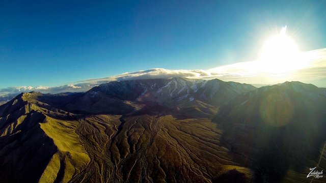
I lensed the image below as I was passing close to Potosi Ridge. On the other side you can see Mount Charleston in the distance. I love shooting split perspective images like this where you have clear focus on both the subject matter in the foreground and also the distant horizons
 Potosi Ridge & Mount Charleston ~ Click to Enlarge
Below is an image I lensed of Lovell Canyon, bearing witness to the beauty of Mount Charleston, cloaked in a blanket of snow and shrouded by clouds. This area is a recreational playground for those willing to take a short drive from the hustle and bustle of Las Vegas.
Located on the remote part of the Spring Mountains that very few people are aware of, it is on the southwest part of the Toiyabe National Forest, directly west and south of Red Rock Canyon. There are remote camping sites for those who want to get away from the crowds.
 Lovell Canyon & Mount Charleston ~ Click to Enlarge
This is the end of Part 1 of this 3 part series on my aerial exploration of the area around Potosi Mountain and the Red Rock Canyon. Stay tuned for Part 2 & 3.
I lensed these images at different times while exploring this awe-inspiring wilderness area for my ongoing project, "Where Eagles Fly".
About The Project
Where Eagles Fly - The American Wilderness Expedition is my personal mission to introduce people to these amazing locations that surround us. I am piloting a bush plane while exploring and filming throughout the remote back-country areas of North America to raise awareness of the 47% of the USA and 90% of Canada that remain unpopulated wilderness.
About The Author
My name is Zedekiah Morse and I'm a Bush Pilot, Photographer, Explorer and Filmmaker. I live in the Rocky Mountains and devote my time and resources to exploring as much of the world as I can by air. If you wish to watch a short film detailing how I do my work and this project, go here.
If you like what you see here upvote and resteemit so that others may experience these wondrous places.
And if you'd like these images to be part of your feed, follow me.
Thanks for your support and Yehaw!!
i like your post. i wait for your next post carry @bijoy123
Thanks! Hope you were able to read the next 2 parts to this series.
Mind-blowing again, especially the last two photos!! Thank you, your posts are truly my favorites!
Forever your biggest steemit fan :D!
LOL! you make me blush! Glad you like the work... hope to live up to your expectations!
I love Charleston Mountain! what beautiful colors ... wonderful images as usual! congratulations my dear friend. great pleasure to watch!
Thanks so much!!! hope you are able to read the other 2 parts to this post series as well
So glad to see these back! 'Potosi Ridge & Mount Charleston' - awesome shot! Think that's my favourite from this selection! Quite the loopy path! Looks pretty fun!
Thanks! It was a blast flying it...
amazing photographs !!
this one is magical
I like that shot as well! Good choice my friend