Hawaii Volcano Update May 24th, 2018
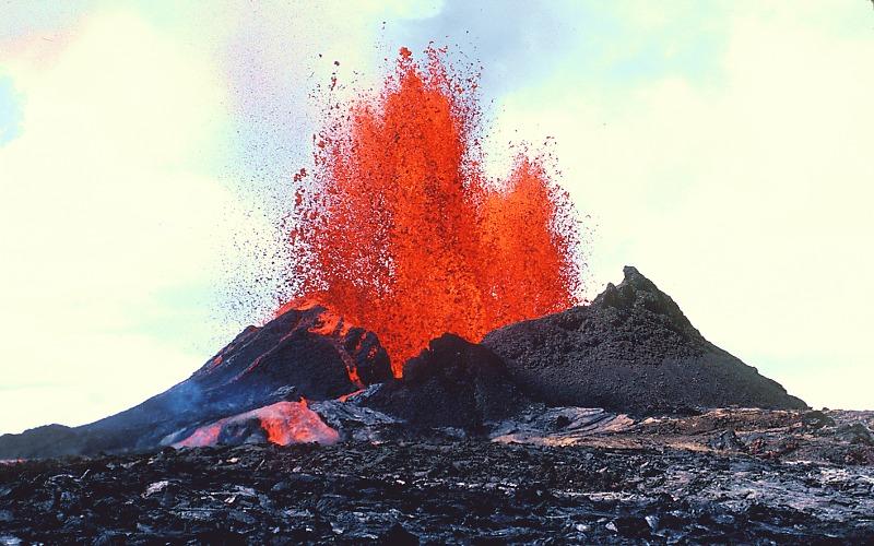
Above: Basalt lava erupts from Pu‘u ‘Ō‘ō cone at Kīlauea Volcano, Hawai‘i. Lava spilling from the cone has formed a series of effusive ‘A‘ā lava channels and flows
Image Credit: J.D. Griggs: "U.S. Geological Survery"
Hawaii Kilauea Volcano Eruptive Vent Below
A Vent is Any opening at the Earth's surface through which magma erupts or volcanic gases are emitted. The below picture shows you where the recent volcanic eruption started in a volcano vent called Pu‘u ‘Ō‘ō cone at Kīlauea Volcano.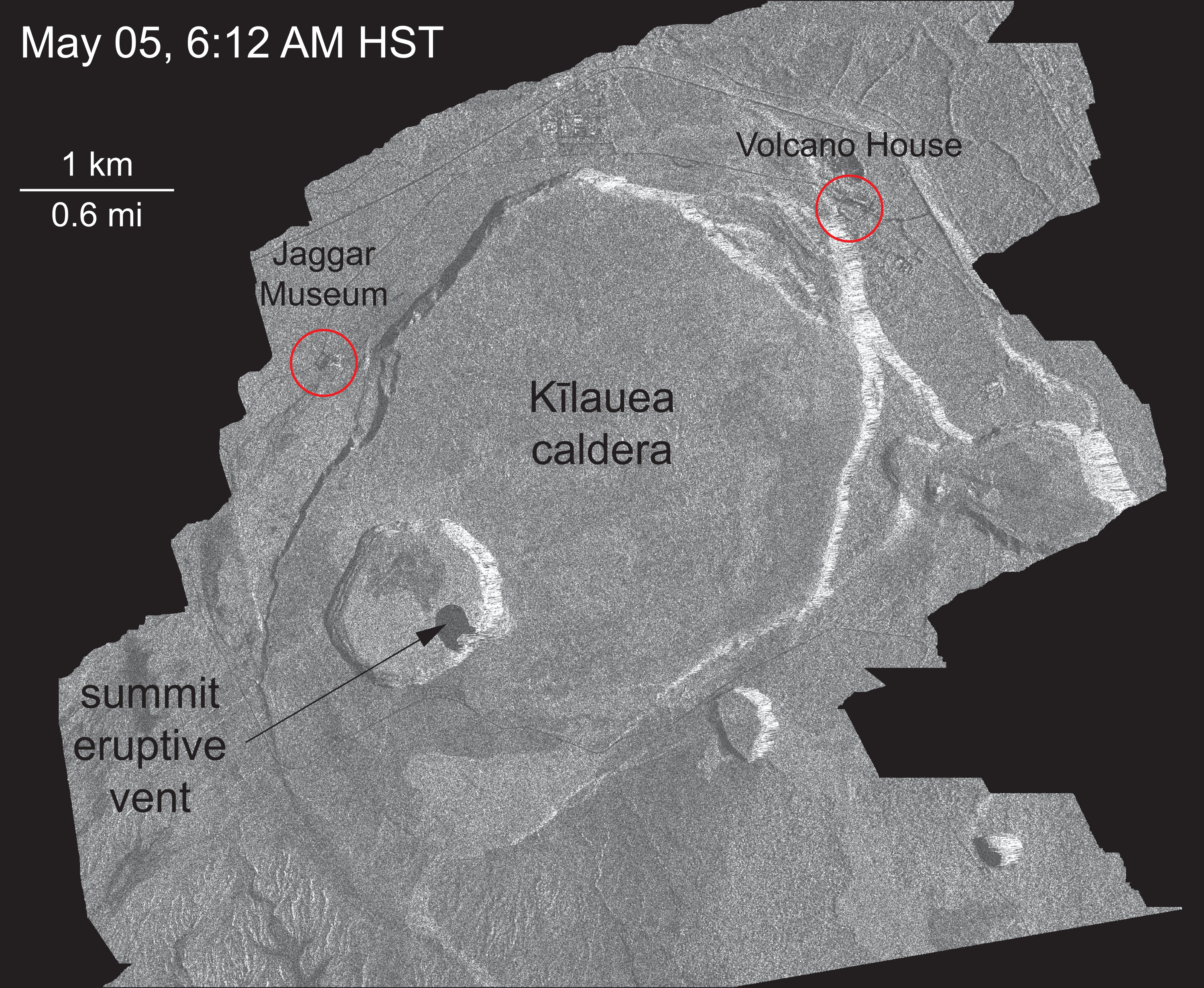
Image Credit: U.S. Geological Survery
Hawaii Kilauea Crater Halema‘uma‘u Vent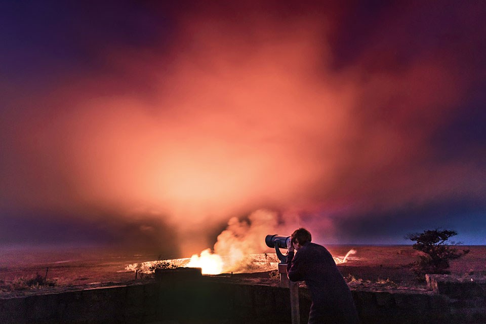
Image Credit: U.S. Geological Survey
LAVA FISSURES
During the current eruption in Hawaii several fissures have opened and the lava emerging from these fissures is responsible for much of the damage.
Fissures:in geology, a fissure is a fracture or crack in rock along which there is a distinct separation; fissures are often filled with mineral-bearing materials. On volcanoes, a fissure is an elongate fracture or crack at the surface from which lava erupts. Image Below is a Fissure.
Image Credit: U.S. Geological Survery
ERUPTION STYLE: the "Curtain of Fire"
As fluid, gas-poor basaltic magma rises up through a fissure, it is extruded at the surface as a wall of incandescent, liquid-to-plastic fragments known as a curtain of fire.
Two such eruptions are shown below from extrusive events on the Kilauea volcano, Hawaii.
Image Credit: U.S. Geological Survey

Image Credit: U.S. Geological Survey
Current Hawaii Eruption 22 Fissures!! Fissure Map: May 9th, 2018.
This thermal map shows the fissure system forming during this current eruption. The fissures are numbered F1, F2, F3, etc... The lava erupting from these fissures or huge cracks in the eart is destroying forests and buildings, including homes and cars in Leilani Estates. The black and white area is the extent of the thermal map. Temperature in the thermal image is displayed as gray-scale values, with the brightest pixels indicating the hottest areas. The thermal map was constructed by stitching many overlapping oblique thermal images collected by a handheld thermal camera during a helicopter overflight of the flow field. The base is a copyrighted color satellite image (used with permission) provided by Digital Globe.
Image Above: Digital Globe used with permission to U.S. Geologic Survey
Image Below: A Single Hawaii Fissure in Leilani Estates, Hawaii
The view from the air: flyover images of the Kīlauea Volcano lower East Rift Zone eruption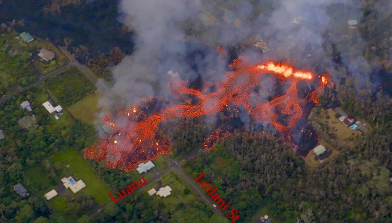
Image Credit: Ann Kalber on Facebook. These images are listed for public use
Image Below: Fissure Erupting in Leilani Estates, Hawaii at night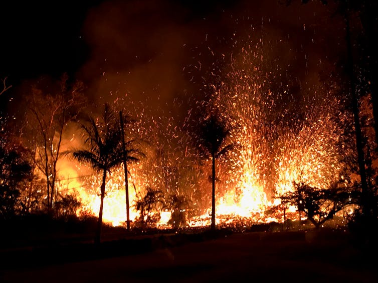
Image credit: (U.S. Geological Survey via AP) The Associated Press
Where the Fissures are in Leilani Estates,Hawaii
Map courtesy of U.S. Geological Survey Status Report: Wednesday, May 23, 2018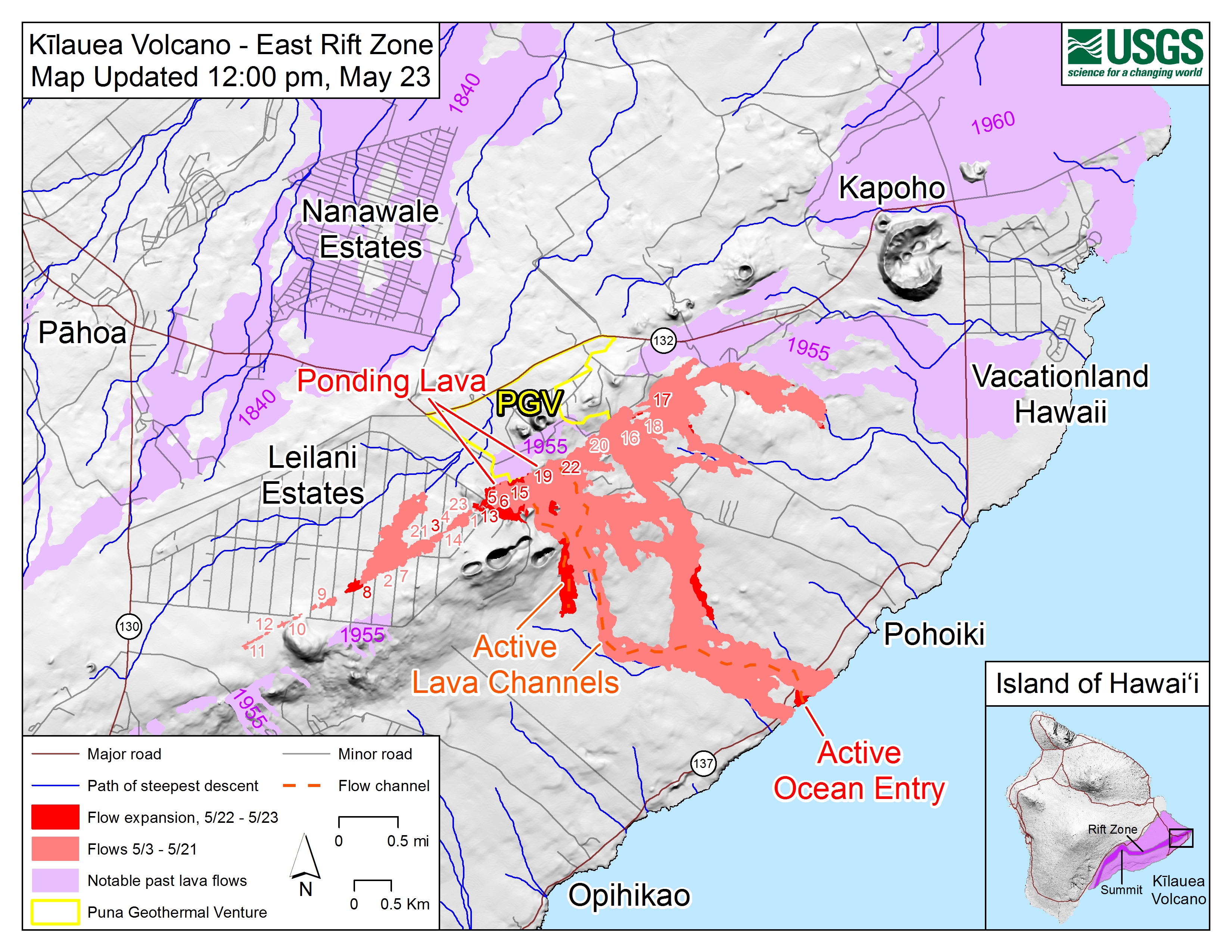
Image Credit:"U.S. Geological Survey"
Lava from Fissure 22
Helicopter overflight of Kīlauea Volcano's lower East Rift Zone shows the lava channel emerging from Fissure 22 (not visible, but to the center, far right of the image). The lava is flowing downhill, from right to left in the photo.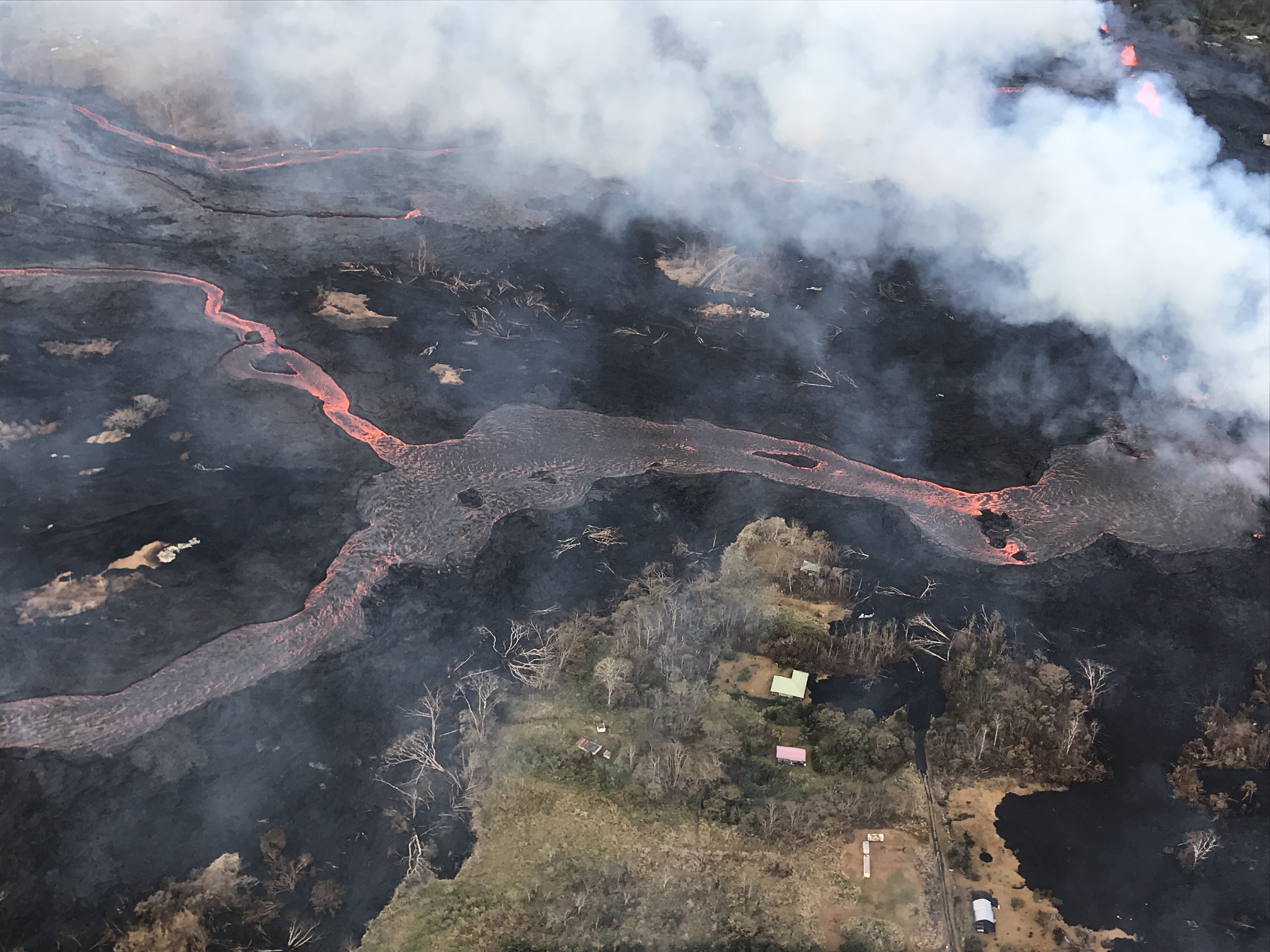
Image Credit:"U.S. Geological Survey"
Image Below:The view from the air: flyover images of the Kīlauea Volcano lower East Rift Zone eruption
Image Credit: Ann Kalber on Facebook. These images are listed for public use
Image Below:Lava rolling down the street in residential area Leilani Estates, Hawaii
Image Credit: USATODAY
A lava flow moves on Makamae Street in Leilani Estates, Hawaii
Image Credit: U.S. Geological Survey
Lava crossing the road
Image Credit: U.S. Geological Survey via Associated Press
Man Standing Next to Lava Flow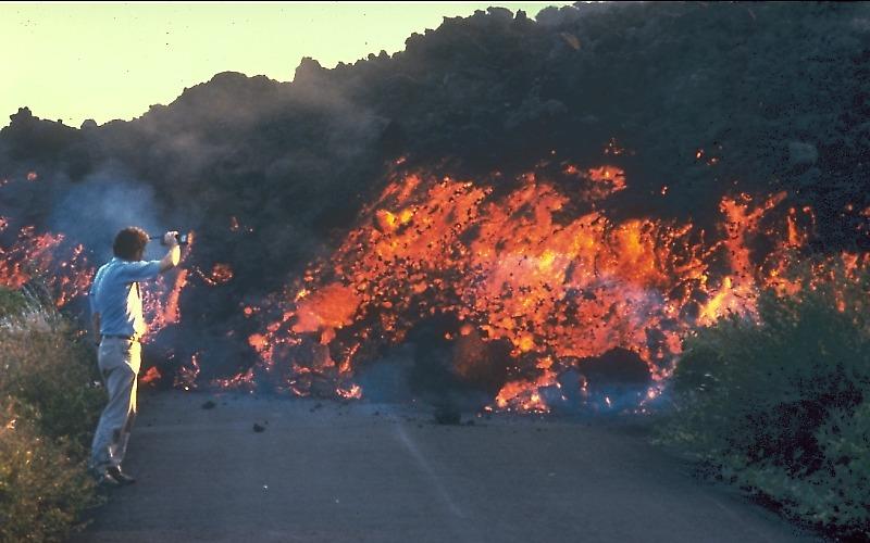
Image Credit: U.S. Geological Survery
Image Below is night hike to Lava Flow lead by professional guide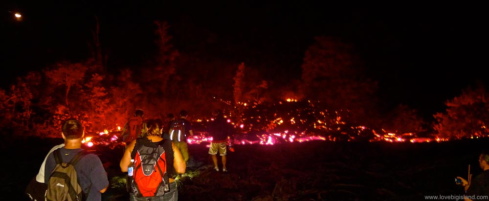
Image Credit : /www.lovebigisland.com
Lava Video From National Park Service
https://www.nps.gov/media/video/view.htm?id=AE7FFCA9-1DD8-B71B-0BCF6E860F56F6DA
Video Credit: U.S. Park Service
Video of Kilauea Crater Wall Collapses into lava causing huge lava ash plume
https://www.nps.gov/media/video/view.htm?id=EE508692-1DD8-B71B-0B5416E65894593E
Image Credit; Rock fall induced ash event on 5/9/2018. Video captured by Park Ranger Jessica Ferracane. Public Domain Video Courtesy U.S. National Park Service
References
http://www.geology.sdsu.edu/how_volcanoes_work/Fissure.html
https://volcanoes.usgs.gov/vsc/glossary/fissure.html
http://www.geology.sdsu.edu/how_volcanoes_work/Hawaiian.html
http://www.geology.sdsu.edu/how_volcanoes_work/Fissure.html#anchor962706
http://www.geology.sdsu.edu/how_volcanoes_work/Thumblinks/Curtainoffire_page.html
https://volcanoes.usgs.gov/vsc/glossary/effusive_eruption.html
Cool. What a great place to be taking pictures right now.
Hi Shauntaemonte
Thanks for checking out my post, upvoting and leaving a comment. It is an exciting place to be with a smell of sulfur in the air and the glow from the volcano can be seen from miles away at night.
The earthquake scared me a little bit, but it’s really just another life experience now.
I hope to have more pictures soon.
Take care
@originalworks
As a follower of @followforupvotes this post has been randomly selected and upvoted! Enjoy your upvote and have a great day!
Hi followforupvotes
Thank you for the upvote.
I appreciate it.
@shortsegmentd