NYC SNOW EXPECTED TOMORROW MORNING
NYC SNOW EXPECTED TOMORROW MORNING
Good morning everyone. We have another mild and rainy one ahead of us today, but as expected, temps drop late and our front has a hard time fully clearing the area. Cold air moving in and a kink along the front, will help move some snow into the area before sunrise tomorrow, and that could create some commuting issues; especially N&W of the NYC area.
SATELLITE


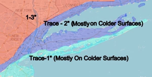
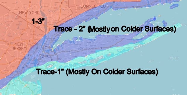
For the City and interior parts of Long Island, including the North Shore, North Fork, and northern parts the South Fork, we're going with a trace-2", with the 2" mark occurring if it doesn't take too long to accumulate. Either way, I'm thinking most of this occurs on colder surfaces, such as tree limbs, cars, grass, and deck surfaces.
The south facing shores as usual, has the toughest time here, with a trace-1" on colder surfaces, if that.

Even with snow falling and temps initially near-freezing, we rise into the mid to upper 30's as the day wears on. This is why that initial snowfall and temps are crucial for those looking for accumulations. If it doesn't happen early, it doesn't happen. It'll make for a pretty scene with snow falling, but eventually we'll be melting as it goes anyway.
Snow ends between 11am-1pm tomorrow, then we clear out and become breezy. Lows dipping into he 20's overnight could cause some icy patches, so use caution when commuting late at night or early Thursday.
Thursday is looking sunny, breezy, and cold, highs in the low to mid 30's.

It doesn't take too long for the next system to lurk the area, with clouds increasing Friday and modifying temps in the mid 40's. Rain moves in between evening and midnight, then look for a rainy Friday night into Saturday.
We're in the warm sector on this one, so look for a repeat of yesterday; with breezy conditions Saturday, rain, and highs in the low to mid 50's. Sunday is the better of the two days, with decreasing clouds and upper 40's to low 50's.
Please note that with regards to any tropical storms or hurricanes, should a storm be threatening, please consult your local National Weather Service office or your local government officials about what action you should be taking to protect life and property.
Posted from my blog with SteemPress : https://www.nycweathernow.com/nyc-snow-expected-tomorrow-morning/