Long Island Heat Not As Extreme Break Comes Next Week
Long Island Heat Not As Extreme Break Comes Next Week

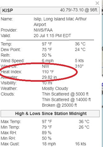
As hot as it is outside today Long Island usually gets a bit of a break from the extreme heat thanks to geography and the cooler ocean. The sea breeze impact lessens considerable as we move through July and August but under the right circumstances at least over Suffolk County and along the shore shore, it usually kicks in around 3 or 4pm in the afternoon and it takes the edge off the heat. The Humidity levels however are off the wall with dew points between 75 & 80. The 1pm temperature at Islip is 70 with 50% relative humidity. That works out to a heat index of 110!

Sometimes you get blow off clouds from thunderstorms to the northwest but they all seem to be disintegrating this afternoon so no help there. The heating should stop once the wind shifts to southwest. In the meantime it is brutally hot and humid so find a way to stay cool.


Tonight will be a steamy night with lows mostly in the 70s to near 80. That gives us another launching pad for Sunday with sunshine taking highs once again to 95 to near 100 with slightly cooler readings at the beaches. Other than a late day pop up thunderstorms no rain is forecast until Monday when we finally catch a break.

A cold front with a wave on the front will be moving through here which will put us in clouds with temperatures in the 80s. Humidity levels will be high again and thanks to the dynamics of the front and the wave, thunderstorms are likely late Monday afternoon and evening. The Storm Prediction Center has Long Island at a marginal risk for severe weather Monday and Monday night. With the wave on that front we will have to wait for it to move by before the weather improves and that won't happen until Tuesday. Showers and thunderstorms will be around Monday night into Tuesday morning before they move out and then it will be slow clearing after that. Highs Tuesday will be in the upper 70s and lower 80s. We will see sunshine and lower humidity Wednesday and Thursday.
Please note that with regards to any tropical storms or hurricanes, should a storm be threatening, please consult your local National Weather Service office or your local government officials about what action you should be taking to protect life and property.
Posted from my blog with SteemPress : https://www.weatherlongisland.com/long-island-heat-not-as-extreme-break-comes-next-week/