Almost But Not Quite With The NYC Pattern
Almost But Not Quite With The NYC Pattern
Good morning everyone. Our quiet week continues as we say goodbye to chilly air and modify things back towards seasonal. Even with a new pattern in place, the "snow drought" continues and we are behind the eight ball for average seasonal snowfall by this time of year. Since we average 26-28" of snow for our area, it wouldn't take much to bring us back from the brink of another below average season, but it's not looking good (at least for now).
SATELLITE

Sunny skies and seasonably average temps rule today with highs in the upper 30's to near 40. Tonight should be our last night of 20's till next week as that cold air begins to modify.

Clouds will dot a blue sky tomorrow, but we remain dry as a bone. Highs in the low to mid 40's. Clouds will increase Friday with the approach of our next system, and we'll stay in the mid 40's.

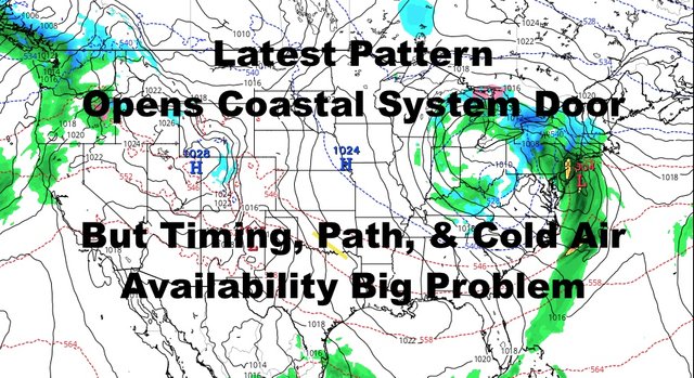
Once again, this one doesn't work out for snow lovers, and it doesn't even look too good for folks N&W of NYC. We were "close", but the ingredients just didn't work out. Saturday's system is coming in as cold air modifies instead of established in the area. Our path takes us over the NYC area or too close to make it viable for a full fledged snowstorm, and low pressure also remains unimpressive. Without a strong low, it has nothing to truly work with as far as being able to pull down departing cold air.
This will equate to a rainy and raw day on Saturday with highs in the low to mid 40's. Areas N&W will probably see a fast snow to rain scenario, with maybe some accumulating snows in the higher elevations of the Catskills and well north and east. Not even areas of PA that some social media outlets held onto for big accumulations, will see much.
It's simply just too weak of a system, not enough cold air, and a hostile path.
On Sunday, low pressure finally strengthens as it pulls into New England and out of picture, and we could have some lingering showers and breezy conditions. If it call pull enough cold air down with late strengthening, we could see some flakes or sleet mixed in with the rainy wraparound moisture before things depart. Otherwise just expect some cold, scattered showers around and a nasty sky.

This is it folks, welcome to our new pattern. Our chances of coastal systems or coastal "huggers" increase compared to the last 2 months, but we have a lack of arctic air strong enough to stick around for more than a few days. Just like Saturday, path and strength are also big factors in terms whether one of these can finally give us a taste of the past 20 years of big snows.
For those old enough to remember the 80's, this is a very similar setup on average. We'll have to watch each system as they come, but with this pattern, we'll need a fairly powerful low to give snow lovers what they want.
Please note that with regards to any tropical storms or hurricanes, should a storm be threatening, please consult your local National Weather Service office or your local government officials about what action you should be taking to protect life and property.
Posted from my blog with SteemPress : https://www.nycweathernow.com/almost-but-not-quite-with-the-nyc-pattern/