Exploration methods to find the black gold, The source of energy that moves the planet.
Hello, Steemians today I would like to address a topic that for many will be something simple and even basic, but for others it will be of great interest and it is about the methods of oil exploration.
Exploration is the term used in the oil industry to designate the search for oil or gas. The purpose of the Exploration process is to maximize the long-term economic value of gaseous and non-gaseous hydrocarbon reserves in the homeland, guaranteeing the safety of its facilities and personnel, in harmony with Venezuelans and the environment. One of the vital processes of the oil industry is exploration, since it depends on the discovery of hydrocarbons (gaseous and not gaseous) in the subsoil.
When the petroleum industry was born, it was very easy to locate deposits, because the very superficial ones were exploited, whose existence was known, or because they were discovered by chance. But the growing importance of this industry, originated an intensive and rational search of new deposits, that was transformed into a true science, with contributions of Geology, physics, chemistry. When there are likely to be accumulations of oil or natural gas in the subsoil, a series of steps is followed, with the purpose of locating the site with greater possibilities of checking them and then extracting them. The geologist's main job is to discover the conditions under which gas and oil accumulate; for this he resorts to different methods of exploration.
Currently, the discovery of oil deposits is not a work done at random and obeys a scientifically organized task, which is planned well in advance. High precision instruments and specialized technicians must be transported to often uninhabited regions, in the desert or in the jungle, forcing roads and communication systems, helicopters, camps and laboratories. The knowledge of the soil structure is fundamental for the rational determination of the possibilities of existence of the deposits. In the search and exploration of oil deposits there is no exact scientific method, but it is necessary to perform many previous tasks of study of the land. The methods used, depending on the type of terrain, will be geological or geophysical.

STAGES OF THE EXPLORATION
One of the first steps in the search for oil is obtaining photographs or images by satellite, plane or radar of a certain surface. This allows geological maps to be drawn up in which characteristics of a certain area are identified, such as vegetation, topography, water currents, type of rock, geological faults, thermal anomalies. This information gives an idea of those areas that have favorable conditions for the presence of sedimentary mantles in the subsoil. Magnetic and gravimetric systems are also used from airplanes equipped with magnetometers and gravimeters, which gathers information that differentiates the types of rock from the subsoil. In addition, geologists personally inspect the selected area and take samples of the surface rocks for analysis. In this field work, gravimetric surface devices are also used to measure the density of rocks in the subsoil. With these studies we have a first approximation of hydrocarbon generation capacity and the quality of storage rocks that may be in place.
Geological Method
It consists of studying the superficial rocks looking for direct indications like menes or springs of petroleum, asphalt and gas; and apply surface geology to verify the existence of rocks associated with the origin and storage of hydrocarbons, and interpret the existence of traps in the ground by observing and measuring their effects on the ground. To this end, aerial photographs are also used. The studies of surface geology require a previous topographic survey with which a relief map is obtained. On this map, the geologists graph the acquired data and from these they interpret the subsoil and its oil possibilities.
The first objective is to find a rock that has been formed in an environment conducive to the existence of oil, that is, sufficiently porous and with the appropriate geological structure of strata so that oil pockets can exist. It is necessary to look, then, for a sedimentary basin that may have organic matter buried more than ten million years ago. For all this, geological studies of the surface are carried out, samples of terrain are collected, inspected with X-rays, drilled to study the strata and, finally, with all these data the geological map of the region under study is made. After new studies "on the ground" that determine if there are oil rocks that can be reached by prospecting, the depth to which it would be necessary to drill, it can already be concluded whether it is worthwhile or not to perform a well-witness or exploration well. In fact, only in one of every ten exploratory wells is it possible to discover oil and only two out of every hundred give results that allow it to be exploited profitably.
GEOLOGY IN OIL EXPLORATION
The exploratory sequence begins with the study of the available information of the area that includes: geological information of the formations and structures present, paleontology, paleoecology, the study of geological and geomorphological maps, study of the geophysical methods that have been used in the area as potential methods (gravimetry, magnetometry, electrical or magneto telluric soundings), seismograph and the results of exploratory drilling carried out in the area. In the analysis of the geological information of the area, the potential of the rocks present in the study area to produce, store and serve as traps to the hydrocarbons is observed. The producing rocks are rocks that contain trapped organic material and that has produced hydrocarbons by processes of high temperature and pressure inside the earth.
The oil is not distributed evenly in the subsoil, it is necessary to have at least four basic conditions for it to accumulate:
- There must be a permeable rock so that under pressure the oil can move through the microscopic pores of the rock.
- The presence of an impermeable rock, which prevents the leakage of oil and gas to the surface.
- The deposit must behave like a trap, since the impermeable rocks must be arranged in such a way that there are no lateral movements of hydrocarbon leakage.
- There must be sufficient and necessary organic material to be converted into oil by the effect of the pressure and temperature that predominates in the deposit.
Geophysical Methods
Geophysics: science that studies the characteristics of the subsoil without taking into account those of the surface - it is applied in the case of the structure of the terrain to be different from its surface, for example, in deserts, jungles or marshes, where geological methods They are ineffective When the land does not have an equal structure on its surface than in the subsoil (for example, in deserts, in forests or swampy areas), the geological methods of studying the surface are not useful, which is why we must use Geophysics , science that studies the characteristics of the subsoil without taking into account those of the surface.
Apparatus like the gravimeter allow to study the rocks that exist in the subsoil. This device measures the differences in the force of gravity in the different soil zones, which allows determining what type of rock exists in the subsoil. With the obtained data a "map" of the subsoil is elaborated that will allow to determine in which zones oil is more likely to exist. The magnetometer is also used, an apparatus that detects the internal disposition of strata and types of rock thanks to the study of the magnetic fields that are created.
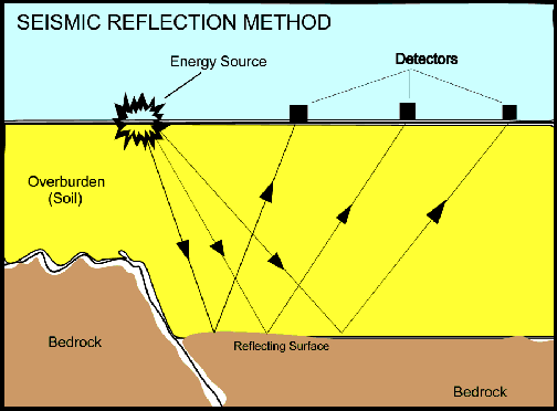
Likewise, seismic survey techniques are used, which study the sound waves, their reflection and refraction, data that allow determining the composition of the rocks of the subsoil. Thus, by means of an explosion, a seismic wave is created artificially that crosses diverse terrains, that is refracted (deviated) by some types of rock and that is reflected (returned) by others and all this at diverse speeds. These waves are measured on the surface by seismographs. More recently, high-resolution three-dimensional seismic techniques allow images of the subsoil to be obtained in their real position, even in complex structural situations. To evaluate large amounts of land where they can be investigated as future oil wells, satellite imagery is the most profitable method of oil and gas exploration available to oil experts today. But, all in all, the presence of oil is not proven until a well is drilled.
SEISMIC METHODS
The Seismograph.
The seismograph is a device of varied design and construction used to measure and record terrestrial vibrations at shallow or deep levels that may be produced by natural events such as tremors and earthquakes or explosions induced intentionally or by atmospheric disturbances, as in the case of shots of artillery.
They consist of blowing up dynamite charges in shallow wells, usually between 10 and 30 feet, recording the waves reflected in the deep layers by means of seismographs combined with photographic machines. On the surface, a certain area is covered with said highly sensitive devices, also called "geophones", which are connected to each other by cables and connected to a receiving station. The waves produced by the explosion pass through the underground layers and return to the surface. The geophones capture them and send them to the receiving station, where by means of special computer equipment, it is drawn inside the earth. The time elapsed between the moment of the explosion and the arrival of the reflected waves can be measured, thus determining the position of the strata and their depth, describing the location of favorable anticlines for the accumulation of oil. All information obtained during the exploratory process is subject to interpretation in the centers.
References
http://www.dnr.louisiana.gov/assets/TAD/education/BGBB/5/techniques.html
https://en.wikipedia.org/wiki/Hydrocarbon_exploration
http://www.passmyexams.co.uk/GCSE/chemistry/finding-crude-oil.html
http://www.oilsandsmagazine.com/technical/properties
http://www.geologicresources.com/seismic_reflection_method.html
https://www.cgg.com/en/What-We-Do/Onshore/General-Geophysics
http://www.collierresources.com/history-of-oil-exploration-development
http://www.eolss.net/sample-chapters/c01/e6-15-08-04.pdf

Congratulations! Your post has been selected as a daily Steemit truffle! It is listed on rank 8 of all contributions awarded today. You can find the TOP DAILY TRUFFLE PICKS HERE.
I upvoted your contribution because to my mind your post is at least 19 SBD worth and should receive 67 votes. It's now up to the lovely Steemit community to make this come true.
I am
TrufflePig, an Artificial Intelligence Bot that helps minnows and content curators using Machine Learning. If you are curious how I select content, you can find an explanation here!Have a nice day and sincerely yours,

TrufflePig