Typhoon 20w (Talim), # 7
Noon Tuesday, Sept. 12, Japan time: Talim has been upgraded to a Category 1-equivalent typhoon by the Joint Typhoon Warning Center. While not forecast to directly impact Okinawa, Talim's latest track brings it ever closer to the island -- and it could impact Kyushu in southwestern Japan by the weekend.
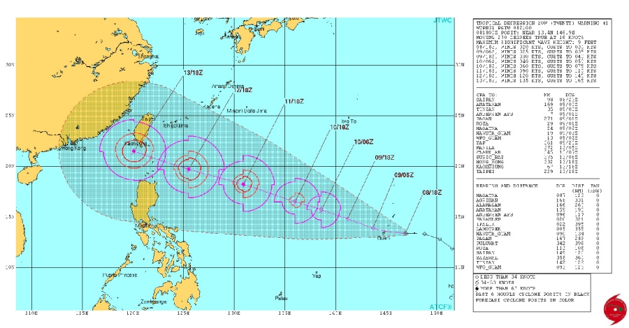
At 9 a.m., Talim was 388 miles south-southeast of Kadena Air Base, headed northwest at 18 mph, 75-mph sustained winds and 92-mph gusts at center. U.S. bases on Okinawa remain in Tropical Cyclone Condition of Readiness Storm Watch, which was issued by 18th Wing command at 9:33 a.m.
If it remains on its current path, Talim is forecast to pass 202 miles southwest of Kadena at 7 a.m. Wednesday, with southwestern portions of Okinawa inside Talim's forecast 34-knot (40-mph) wind bands.
Long-range weather forecast at Shogunweather.com projects between 60- and 70-percent chance of showers and thunderstorms, with winds peaking at 27-mph sustained with 41-mph gusts as Talim passes south of Okinawa. Taiwan and the Philippines appear to be more out of harm's way than previously forecast.
Talim is forecast to peak at Category 4-equivalent strength, 132-mph sustained winds and 161-mph gusts, as it bends northeast of Taiwan into Thursday morning. No warnings have been issued by Taiwan's Central Weather Bureau. Talim is forecast to pass 130 miles north-northeast of Taipei, the island's capital, at 3 a.m. Thursday Taiwan time.
Model guidance remains spread. It's generally agreed that Talim won't directly impact southeastern China, but GFS ensemble and CMC ensemble both suggest a more direct impact on Okinawa and Japan's main islands, which would be a first for the season. This one bears close watching.
11 a.m. Tuesday, Sept. 12, Japan time: U.S. bases on Okinawa have entered Tropical Cyclone Condition of Readiness Storm Watch. Though Talim is not forecast to threaten Okinawa directly, as a precaution, readiness condition has been upgraded, in case the track changes.
5:30 p.m. Monday, Sept. 11, Taiwan time: Talim is approaching Category 1-equivalent typhoon strength, has picked up forward speed and continues on a course taking it well south of Okinawa while possibly putting Taipei in its sights, according to the Joint Typhoon Warning Center’s latest forecast track.
At 2 p.m., Tropical Storm Talim was 685 miles southeast of Kadena Air Base, steaming west-northwest at 18 mph, 69-mph sustained winds and 86-mph gusts at center. JTWC projects Talim to peak at just below Category 4-equivalent strength, 127-mph sustained winds and 155-mph gusts at center before plowing ashore over northeastern Taiwan early Thursday morning.
If it remains on its current track, Talim is due to pass 8 miles south-southwest of Taipei at about 4 a.m. Thursday, emerge back over the Formosa Strait, then make secondary landfall over southeastern China at mid-afternoon Thursday. Okinawa should be well out of harm’s way; JTWC depicts Talim passing 285 miles south-southwest of Kadena at 1 a.m. Wednesday.
Model guidance agrees that Talim should curve north and northeast; the question being when and where? GFS ensemble suggests a hard right turn after Talim brushes the Chinese coast, then barrel northeast toward Japan; CMC ensemble forecasts a turn much earlier, before even reaching Taiwan, and curving toward Okinawa.
No watches or warnings have been issued yet for Taiwan by its Central Weather Bureau. U.S. bases on Okinawa remain in seasonal Tropical Cyclone Condition of Readiness 4, according to Kadena’s 18th Wing Weather Flight’s official Web site Shogunweather.com.
Meanwhile, in the Philippines, a low-pressure area was designated a tropical depression by the country's weather authority PAGASA and has been named Maring. Tropical Cyclone Warning Signal 1 has been issued for areas of central Luzon island.
article continues below
10 p.m. Sunday, Sept. 10, Taiwan time: Slight adjustment to Tropical Storm Talim’s forecast track, now taking the 20th numbered storm of the northwest Pacific’s tropical cyclone season through the heart of Taiwan sometime early Thursday morning, according to the Joint Typhoon Warning Center.
At 8 p.m., Talim was 500 miles northwest of Andersen Air Force Base, Guam, moving west-northwest at 13 mph, holding steady at 46-mph sustained winds and 58-mph gusts.
If Talim continues moving as forecast, it will bisect Taiwan, passing 92 miles north-northeast of Kaohsiung and 93 miles south-southwest of Taipei, the island’s capital, between 4 and 7 a.m. Thursday as a Category 1-equivalent typhoon, 86-mph sustained winds and 104-mph gusts at center. Talim is forecast to peak as a Category 3-equivalent typhoon before reaching landfall.
Models continue to disagree: GFS ensemble projects a curve back out over water after making landfall over southeastern China by next weekend. CMC ensemble has Talim brushing Taiwan’s northeast coast before turning northeast, west of Okinawa, and toward the Tsushima Strait between Korea and southwestern Japan.
12:30 p.m. Sunday, Sept. 10, Taiwan time: Tropical Storm Talim continues tracking well west of the Marianas Islands, and the latest Joint Typhoon Warning Center forecast track now takes Talim through central Taiwan as a Category 4-equivalent typhoon by mid-week.
At 11 a.m., Talim was 395 miles west-northwest of Guam, tracking west-northwest at 13 mph with 46-mph sustained winds and 58-mph gusts at center. Talim is forecast to keep tracking west-northwest on a route taking it 56 miles north-northeast of Kaohsiung and 130 miles south-southwest of Taipei, Taiwan’s capital, between 3 and 6 a.m. Thursday. It’s expected to be packing 132-mph sustained winds and 161-mph gusts before making landfall.
Model guidance remains spread. The GFS ensemble
has Talim making landfall over southeastern China, then making a sharp right turn northeast toward southwestern Japan. The CMC ensemble still doesn’t have Talim even reaching Taiwan, instead making a 90-degree turn right and trucking north-northeast toward Okinawa and the Tsushima Strait between Korea and Kyushu.
2 a.m. Sunday, Sept. 10, Guam time: Talim has been upgraded to a tropical storm as it continues west out of the Marianas Islands, with the latest Joint Typhoon Warning Center forecast track taking Talim over southern Taiwan and into southeastern China later this week.
At 10 p.m., Talim was 180 miles northwest of Andersen Air Force Base, Guam, headed west-northwest at 11 mph, 40-mph sustained winds and 52-mph gusts at center. If it remains on its present course, Talim is forecast to pass 15 miles south-southwest of Kaohsiung at 7 a.m. Thursday as a Category 4-equivalent typhoon, 132-mph sustained winds and 161-mph gusts at center as it roars past.
Just a matter of where it goes after making landfall over China, if it gets that far. The GFS ensemble still indicates a straight westerly run into southeastern China, while the CMC ensemble indicates a right turn just before Taiwan and heading toward the Tsushima Strait between Korea and southwestern Japan.
7:50 a.m. Saturday, Sept. 9, Guam time: A new tropical depression spawned east of Guam overnight Friday, and the initial Joint Typhoon Warning Center track bears bad news for the northern Philippines and southern Taiwan: 20W is forecast to intensify to super-typhoon strength.
At 7 a.m., 20W was 90 miles east of Andersen Air Force Base, headed west at 18 mph, 25-mph sustained winds and 35-mph gusts. According to the National Weather Service on Guam, 20W is forecast to race through the Marianas Islands over the weekend, intensifying into a tropical storm after it passes well west of the islands.
JTWC projects 20W peaking as a super typhoon early Thursday morning. Although they generally agree on a west-northwest track toward the Philippines and Taiwan, model guidance disagrees somewhat on actual track and peak intensity. That’s normal at this point in the life of a developing storm. PST is keeping an eye on it.
2 p.m. Friday, Sept. 8, Guam time: A tropical cyclone formation alert has been issued by the Joint Typhoon Warning Center on a disturbance about 750 miles east-southeast of Guam.
Model guidance (GFS ensemble and CMC ensemble) points to the system developing by Saturday or Sunday and tracking west-northwest, toward the Philippines and Taiwan and possibly on toward southeastern China — which has been battered by three such tropical cyclones in the last month. Okinawa may be affected as well. PST has an eye on it.
sourse:https://www.stripes.com/news/pacific/typhoon-20w-talim-7-1.486666#.WbeUwbLyjcc
This post has been ranked within the top 50 most undervalued posts in the first half of Sep 12. We estimate that this post is undervalued by $13.61 as compared to a scenario in which every voter had an equal say.
See the full rankings and details in The Daily Tribune: Sep 12 - Part I. You can also read about some of our methodology, data analysis and technical details in our initial post.
If you are the author and would prefer not to receive these comments, simply reply "Stop" to this comment.