Why a plane can’t fly in one straight line from one airport to another? (Bilingual)
Ps. This maybe will explain that the earth is round, not flat.
Hello everyone, so apparently i’ve been hiding from the world so couldn’t post anything for almost one week, my apologize for that. So today i want to share something, that maybe you have never question in your mind. Have you ever seen airplanes flying through the air and wondered whether the planes actually went straight to get to their destination faster? Does the theory that is following a straight line to reach the place more quickly apply to the plane flight?
The answer would be "Yes" that the airplanes follow a straight line, but only you can't see it through the surface of a flat world map. And to be "No" Due to the assumption that an airplane in a straight line to reach its destination more like an "airplane through the earth" is quite possible, with Doraemon's magical equipment. But this also does not mean that they have to round the big mountain when doing the flight. The fact is even for a Jumbo Jet class of plane, they can fly at an altitude of about 12,000 meters, which means like jumping Mount Everest which has a height of 9,000 meters. Well if the plane were able to fly past anything why the planes did not take a straight line between the two places as the shortest distance in their flight?
Confuse? Yea, me too.
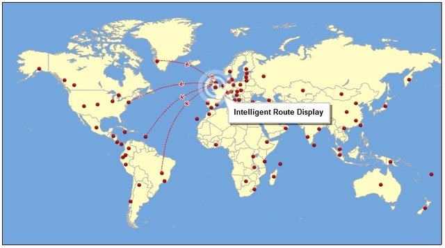
Basically this question uses two different things to use as an explanation. That is using a flat map, and the curvature of the earth. If you look carefully at the flight map, you will see a winding path, why do you not find a straight line from one place to another. Is that impossible? No, it is possible, if, "if" the world is as flat as the map itself. In fact, on a flat surface you will indeed find that the shortest distance between two points, like point A and point B for an example. But it will be different if both points are on two different sides where there is a large, solid object that can not be exceeded, instead of the movement of a straight line, then we are required to take the turning path. And this is certainly the shortest path that takes you around the curved surface of the Earth, instead of flying straight through the earth as if there were a magical tunnel in it. From the above explanation it can be understood that the aircraft made its flight in a curved way, following the curved surface of the earth beneath it. So if the route is depicted on a flat map of the earth between the destination and the origin of the flight it will look more like a straight line that is bent up and down so as to form its own curve. But if we look at the route through a round map, like a globe or 3-dimensional map, then we will find that the actual flight path of the plane is a fairly straight line. [1]
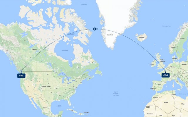
The image above explain that Your map is a two-dimensional representation of the surface of the Earth – which is not flat but rather an ‘oblate spheroid.’ The shortest route is not a straight line on the map – it’s a part of a ‘great circle.’ So the shortest route between Vancouver and Paris (both 49 degrees north) is via Greenland (68 degrees north).
And about the route, to be able to find the required route of the arch as the destination route, such calculations are performed by the flight navigation computer. So once the pilot of the plane finds the right track, then all he need to do is to follow the line . The "auto-pilot" feature on the aircraft itself uses this curvilinear route as its reference. To be able to determine which curves can be used as flight routes the computer must take into a serious counting about certain things in order to avoid errors in route selection used. In theory, the shortest distance between two point on the surface of the globe always follows a giant circle around the globe with the center of the earth at its center. The equator is the outline that surrounds the earth horizontally. While the path from the north pole to the south pole forms another large vertical circle. And between the two circles there are many other large circles, so to find the shortest distance between the two airport, computers will look for an outline with both airports on the perimeter and the center of the earth as its center. The curvature (the circle) between the two airports is called "Geodesic" and the curved path is followed by the plane. [2]
Any route from one airport to another goes through these air tracks; an airplane does not fly in a direct line, it moves from one spot to another
Although this curve line can be the shortest path if we look at it from the flight map. It doesn’t mean that this path is the the fastest or safest flight duration. Because the curve could have crossed the no-fly zone, or too close to the other aircraft's flight path, this is where the air traffic controller becomes their guide. And because of this is sometimes the flight of an aircraft are taking much more time, because the aircraft must take an alternative path to to avoid storms or no-fly zone that exists.
Well thats i can bring for this post. Feel free to respond with any comment below, if you had some question or anything to respond, i’m sure thats gonna help. So thanks for giving your time to read my short article. See you next time ~ best regard @Andretarina2468
Reference :
[1]Earth isn't flat
[2]Aircraft Routing
Indonesian Translate
Mangapa pesawat tidak terbang dalam satu garis lurus dari satu bandara ke bandara lainnya?
Ps. Mungkin ini akan menjelaskan bahwa bumi itu bulat, bukan datar.
Hai semuanya, jadi untuk beberapa hari ini saya sedikit bersembunyi dari dunia, sehingga tidak dapat memposting apapun maafkan saya untuk itu. Dan hari ini saya ingin membagikan suatu informasi yang mungkin tidak pernah terpikirkan oleh temanteman sebelumnya. Pernahkah kalian melihat pesawat yang tengah terbang di udara dan berpikir, apakah sebenarnya pesawat-pesawat itu menempuh garis lurus untuk mencapai tempat tujuannya lebih cepat? Apakah teori mengikuti garis lurus untuk mencapai tempat lebih cepat berlaku pada penerbangan pesawat?.
Jawabannya akan menjadi “Ya” bahwa pesawat terbang mengikuti garis lurus hanya saja kalian tidak melihatnya melalui permukaan peta dunia yang datar. Dan menjadi “Tidak” Karena anggapan bahwa pesawat terbang dalam satu garis lurus untuk mencapai tempat tujuannya lebih seperti “pesawat terbang menembus bumi” itu sangat mungkin dilakukan, dengan peralatan ajaib Doraemon. Namun hal ini juga tidak berati bahwa mereka harus memutari gunung besar ketika melakukan penerbangan. Faktanya untuk pesawat sekelas Jumbo Jet dapat terbang pada ketinggian sekitar 12.000 meter, yang artinya seperti melompati gunung Everest yang memiliki tinggi 9.000 meter. Nah jika pesawat mampu terbang melewati apapun mengapa pesawat-pesawat itu tidak mengambil garis lurus antara dua tempat sebagai jarak terpendek dalam penerbangan mereka?
Anda bingung? Ya saya juga.
Pada dasarnya pertanyaan ini menggunakan dua hal berbeda untuk digunakan sebagai penjelasannya. Yaitu menggunakan peta datar, dan garis lengkungan bumi. Jika kalian perhatikan dengan seksama pada peta penerbangan, kalian akan melihat jalur yang berkelok-kelok, mengapa kalian bukannya menemukan garis lurus dari satu tempat ke tempat lainnya. Apakah hal itu mustahil? Tidak, hal itu dimungkinkan, jika, “seandainya” dunia memang datar seperti peta itu sendiri. Faktanya, pada permukaan yang datar kalian memang akan menemukan bahwa jarak terpendek antara dua titik yaitu titik A dan titik B. Namun akan beda hasilnya jika kedua titik itu berada pada dua sisi berbeda dimana terdapat benda besar nan padat yang tidak dapat dilampaui, alih-alih melakukan pergerakan garis lurus, maka kita diharuskan berputar. Dan hal ini tentunya merupakan jalur terpendek yang membawamu memutari permukaan melengkung yang dimiliki Bumi, bukannya terbang lurus menembus bumi seakan-akan terdapat terowongan ajaib didalamnya. Dari penjelasan tadi maka dapat dimengerti bahwa pesawat melakukan penerbangannya dengan cara melengkung, mengikuti permukaan melengkung bumi dibawahnya. Sehingga jika rute tersebut digambarkan pada peta bumi datar garis antara tempat tujuan dengan tempat asal penerbangan maka akan lebih terlihat seperti sebuah garis lurus yang ditekuk keatas dan kebawah sehingga membentuk lengkungan tersendiri. Namun jika kita melihat rute tersebut melalui peta berbentuk bulat, seperti globe atau peta 3 dimensi, maka kita akan menemukan bahwa sebenarnya jalur penerbangan pesawat tersebut berbentuk garis yang cukup lurus. [1]
Gambar di atas menjelaskan bahwa peta yang kita gunakan adalah representasi dua dimensi permukaan Bumi - yang tidak datar melainkan 'bola kencang'. Rute terpendek bukanlah garis lurus pada peta - ini adalah bagian dari ' lingkaran besar. 'Jadi rute terpendek antara Vancouver dan Paris (keduanya 49 derajat ke utara) adalah melalui Greenland (68 derajat ke utara).
Untuk dapat menemukan rute lengkungan yang dibutuhkan sebagai rute tujuan, perhitungan semacam itu dilakukan oleh komputer navigasi penerbangan. Sehingga begitu Pilot pesawat menemukan jalur yang seharusnya, maka dia hanya tingal mengikutinya. Fitur “auto-pilot” pada pesawat sendiri menggunakan rute lengkungan ini sebagai acuannya. Untuk dapat menentukan lengkungan mana yang dapat dipergunakan sebagai rute penerbangan komputer harus mempertitungkan beberapa hal tertentu agar tidak terjadi kesalahan dalam pemilihan rute yang digunakan. Secara teori, jarak terpendek antara dua titi di permukaan bola bumi selalu mengikuti lingkaran raksasa ke sekeliling bola bumi dengan bagian tengah bumi sebagai pusatnya. Khatlistiwa merupakan garis besar yang mengelilingi bumi secara horizontal. Sementara jalur dari kutub utara ke kutub selatan membentuk satu lagi lingkaran besar yang Vertikal. Dan diantara kedua lingkaran tersebut terdapat banyak lingkaran besar lain, sehingga untuk menemukan jarak terpendek antara dua bandara komputer akan mencari garis besar dengan kedua bandara di garis kelilingnya dan bagian tengah bumi sebagai pusatnya. Lengkungan (bagian lingkaran) diantara kedua bandara disebut “Geodesic” dan jalur melengkung itulah yang diikuti oleh pesawat. [2]
Rute dari satu bandara ke bandara lain melewati jalur udara ini; sebuah pesawat tidak terbang dalam jalur langsung, bergerak dari satu tempat ke tempat lain
Walupun jalur melengkung ini dapat berupa jalur terpendek jika kita melihatnya dari peta penerbangan. Bukan berarti jalur ini merupakan jalur dengan durasi penerbangan tercepat atau teraman. Karena bisa saja jalur melengkung tadi melewati zona larangan terbang, ataupun terlalu dekat dengan jalur terbang pesawat lainnya, disinilah pengendali lalu lintas udara menjadi pemandu mereka. Dan karena sebab inilah terkadang penerbangan suatu pesawat menjadi lama, dikarenakan pesawat harus mengambil alternatif jalur yang lain untuk menghindari badai ataupun zona larang terbang yang ada.
Well hanya ini yang dapat saya berikan untuk postingan kali ini. Jangan ragu untuk menanggapi dengan komentar di bawah, jika Anda memiliki beberapa pertanyaan atau jawaban apa pun, saya yakin itu akan membantu. dan terima kasih telah memberikan waktumu untuk membaca artikel singkat ini. Sampai jumpa lagi
~ best regard @ Andretarina2468

)
